FAA Information Effective: Jul 10, 2025
All information is provided from the FAA unless otherwise noted.
(KOGA) Searle Field
1 rating | 2 reviews
Overview
Attendance:
Attended
Year-round,Mon-Fri/0730-1630
FAA
Elevation:
3,279 ft (Surveyed)
Tower:
No
Airspace:
Unknown
Fees:
Landing, Overnight, Ramp, Other
Click FBO link(s) below for details:
Click FBO link(s) below for details:
FBO Fee Details:
City of OgallalaTimezone:
MDT (UTC-06:00)
Sunrise-Sunset:
5:37 am - 8:12 pm
Evening-Morning Civil Twilight:
8:43 pm
(Today)
(Today)
-
5:06 am
(Tomorrow)
(Tomorrow)
Minimum Fuel Prices:
$5.00
100LL (self)
$3.98
Jet-A (self)
Runway
Satellite
Sectional
FBOs
Submit New FBO
City of Ogallala
No ratings | Be the first to review this business
Services Offered:
$5.00 | 100LL | self
$3.98 | Jet-A | self
Location:
On field: E
Phone:
(308) 284-3848
Freq. Monitored:
Fees:
Landing, Overnight, Ramp, Other
Flight Training
Submit New Flight School
Other businesses
Submit New Business
AOPA Travel Discounts 
FlightBridge is the ultimate all-in-one travel booking platform built for the general aviation community. AOPA Members receive free access to FlightBridge with AOPA discounted rates automatically applied. Members save an average of 30% on hotel bookings! Learn more about FlightBridge HERE.
Local Food/Lodging/Activities
Local Attractions
Local Activities
Restaurants
Hotels and Lodging
Travel Discounts
Peking Chinese Restaurant
(308) 284-8300
(308) 284-6006
(308) 284-3800
(308) 284-9812
(308) 284-6000
(308) 284-3917
(308) 284-8188
(308) 284-2300
(308) 284-2274
(308) 284-9879
OGA
Lake McConaughy
Peking Chinese Restaurant
Pizza Hut
Runza Restaurant
Golden Village
Front St Steakhouse
Arby's
Denny's
Golden Spur Steakhouse
McDonald's
3 Margaritas
Flying Clubs
Submit New Flying Club
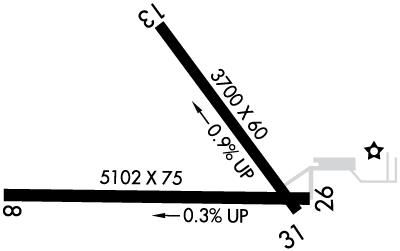
Runway 08/26
Dimensions:
5,102 × 75 ft
(1,555 × 23 m)
(1,555 × 23 m)
Weight Bearing Cap:
Single wheel: 13,000 lbs
Double wheel: 13,000 lbs
Double wheel: 13,000 lbs
Surface:
concrete, no surface treatment, in good condition
Runway Edge Lights:
Medium
Comments:
n/a
| Designator: | 08 | 26 |
| Elevation: | 3,260.4 ft | 3,245 ft |
| Heading: | 083° magnetic 090° true | 263° magnetic 270° true |
| Gradient: | 0.3% down | 0.3% up |
| Traffic Pattern: | Left Pattern | Left Pattern |
| Markings: | non-precision, in Good condition | non-precision, in Good condition |
| Approach Lighting: |
|
|
| Displaced Threshold: | n/a | n/a |
| ILS/LOC: | n/a | n/a |
| Obstructions: | n/a | n/a |
| Comments: | Calm Wind Rwy. FAA Rwy 08 Unlgtd Cntr Pivot Sys Rots Thru Approach Durg Irrigation Season. FAA | n/a |
Runway 13/31
Dimensions:
3,700 × 60 ft
(1,128 × 18 m)
(1,128 × 18 m)
Weight Bearing Cap:
Single wheel: 13,000 lbs
Double wheel: 13,000 lbs
Double wheel: 13,000 lbs
Surface:
concrete, no surface treatment, in excellent condition
Runway Edge Lights:
Medium
Comments:
n/a
| Designator: | 13 | 31 |
| Elevation: | 3,279.3 ft | 3,244.8 ft |
| Heading: | 137° magnetic 144° true | 317° magnetic 324° true |
| Gradient: | 0.93% down | 0.93% up |
| Traffic Pattern: | Left Pattern | Left Pattern |
| Markings: | non-precision, in Good condition | non-precision, in Good condition |
| Approach Lighting: |
|
|
| Displaced Threshold: | n/a | n/a |
| ILS/LOC: | n/a | n/a |
| Obstructions: | Road, 320 ft Left ft of center, 30 ft high, 670 ft from end, 15:1 clearance slope | n/a |
| Comments: | n/a | n/a |
TFRs
Location: OGA
Please verify all content below using the FAA TFR Search Site or with a flight briefer.
TFR count: 0
NOTAMs
Location: OGA
Please verify all content below using the FAA NOTAM Search Site or with a flight briefer.
NOTAM count: 6
| Number: | Start Date: (UTC) | End Date: (UTC) | Condition: |
|---|---|---|---|
| 07/010 | 07/18/2025 2322 | 09/01/2025 2319 | OBST TOWER LGT (ASR 1026730) 410832.70N1014249.80W (2.9NM ENE OGA) 3641.1FT (307.1FT AGL) U/S |
| 07/011 | 07/20/2025 0301 | 09/03/2025 0301 | OBST TOWER LGT (ASN 2023-ACE-6110-OE) 412557N1014238W (19.0NM NE OGA) 3872FT (310FT AGL) U/S |
| 07/012 | 07/24/2025 0344 | 09/07/2025 0343 | OBST TOWER LGT (ASR 1026728) 410833.40N1014256.40W (2.8NM ENE OGA) 3613.8FT (251.0FT AGL) U/S |
| 07/009 | 07/13/2025 1507 | 07/31/2025 2359 | AD AP 100LL FUEL NOT AVBL |
| 4/5202 | 03/08/2024 1825 | IAP SEARLE FLD, OGALLALA, NE.
RNAV (GPS) RWY 31, ORIG-D...
PROFILE NOTE: VGSI AND RNAV GLIDEPATH NOT COINCID… | |
| 07/002 | 07/02/2025 1126 | 10/30/2025 1126 | OBST TOWER LGT (ASR 1025829) 411713.90N1015019.90W (10.5NM NNW OGA) 3742.8FT (314.0FT AGL) U/S |
Additional Remarks
For Cd If Una to CTC on FSS Freq, CTC Denver ARTCC at 303-651-4257.
Source:
FAA
Federal Aviation Administration
Noise Abatement
Instrument Procedures
Data Cycle:
Operations & More Information
Lat/Long:
- 41.11947, -101.76969
- 41° 7′ 10.1″ N, 101° 46′ 10.9″ W
- 41° 7.168′ N, 101° 46.182′ W
ARTCC:
Denver (ZDV)
App/Depart Control Facility:
Unknown
Chart:
NACO: Cheyenne Sectional
FSS:
Columbus (OLU)
1-800-WX-BRIEF
1-800-WX-BRIEF
Wind Indicator:
Lighted
Mag Var:
07E (2015)
NOTAM Facility:
Seg Circle:
Yes
Beacon:
Present
Lighting:
Pilot Activated Lighting:
- low intensity: 3 clicks in 3 secs
- medium intensity: 5 clicks in 5 secs
- high intensity: 7 clicks in 7 secs
AM
Actvt PAPI Rwy 08, 26 & 31; VASI Rwy 13; MIRL Rwy 13/31 & 08/26 - CTAF.
FAA
Pattern Altitude:
No data provided. Assume 1000 AGL.
Special Operations:
Communications Card
| Type: | Frequency / Phone: | Sector / Comments: | Call Sign: |
|---|---|---|---|
| AWOS-3 | 121.275T (308) 284-6573 | ||
| CTAF | 122.8 | ||
| UNICOM | 122.8 |
Navaids
Services
Fuel:
100LL Low-Lead
AM
Engine Repair:
Major
AM
Airframe Repair:
Major
AM
Bottled Oxygen:
High
AM
Bulk Oxygen:
None
Customs:
None
Transportation:
Courtesy Transportation
AM
Activities:
None Reported
Camping On Field:
None Reported
Aircraft & Activity
Webcams
METARs
TAFs
Contact Addresses
Airport Manager
Kevin Wilkins
Ogallala, NE 69153-2631
(308) 284-6001 (Office)
Owner
City of Ogallala
Ogallala, NE 69153-2631
(308) 284-6001 (Office)
Remarks:
Airport Reviews
Overall:
1 rating | 2 reviews
Runways and Taxiways:No ratings
Markings and Signage:No ratings
Ground Transportation:No ratings
Sort By:
- 6/11/19Frank L.TRIED to fly in to Ogallala airport to do some sightseeing. To do that, needed a rental car. Turns out that the only way to get a rental car is from Schmidt Motors who apparently has one car and it was not available and the "FBO" covets their court…
- 10/11/15MICHAEL D.Did a weather RON at KOGA, after hours got staff on phone, great service for that. Courtesy car and lobby accessible after hours, supplied tie downs and lobby access. Mike at Candy was very helpful, great place.