FAA Information Effective: Jun 12, 2025
All information is provided from the FAA unless otherwise noted.
(KORF) Norfolk International Airport
No ratings | 5 reviews
Overview
Attendance:
Attended
Year-round, 7 Days a Week,All
FAA
Elevation:
26 ft (Surveyed)
Tower:
Said In Use. Operate Transponders With Altitude Reporting Mode And Ads-B (If Equipped) Enabled On All Airport Surfaces.
FAA
Primary Approach Control Hrs: 24
FAA
Primary Depart. Control Hrs: 24
FAA
Tower Hrs: 24
FAA
Airspace:
C
Fees:
Handling, Landing, Overnight, Other
Click FBO link(s) below for details:
Click FBO link(s) below for details:
FBO Fee Details:
Signature Flight SupportTimezone:
EDT (UTC-04:00)
Sunrise-Sunset:
5:46 am - 8:27 pm
Evening-Morning Civil Twilight:
8:58 pm
(Today)
(Today)
-
5:15 am
(Tomorrow)
(Tomorrow)
Minimum Fuel Prices:
$7.45
100LL (full)
$6.50
Jet-A (full)
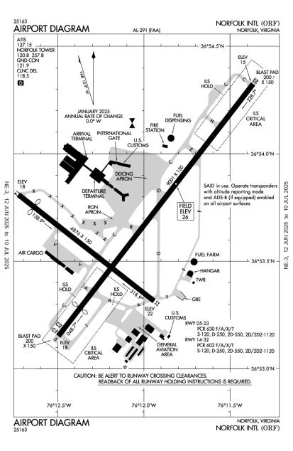
Runway
Satellite
Sectional
FBOs
Submit New FBO
Signature Flight Support
2 ratings | 2 reviews
Services Offered:
$7.45 | 100LL | full
$6.50 | Jet-A | full
Location:
On field: SE
Phone:
(757) 857-3463
Freq. Monitored:
ASRI: 130.57
Fees:
Handling, Landing, Overnight, Other
Flight Training
Submit New Flight School
Other businesses
Submit New Business
AOPA Travel Discounts 
FlightBridge is the ultimate all-in-one travel booking platform built for the general aviation community. AOPA Members receive free access to FlightBridge with AOPA discounted rates automatically applied. Members save an average of 30% on hotel bookings! Learn more about FlightBridge HERE.
Local Food/Lodging/Activities
Local Attractions
Local Activities
Restaurants
Hotels and Lodging
Travel Discounts
6700 Azalea Garden Rd, Garden Rd, VA 23518
(757) 441-5830
ORF
Norfolk Botanical Garden
Flying Clubs
Submit New Flying Club
Runway 05/23
Dimensions:
9,001 × 150 ft
(2,744 × 46 m)
(2,744 × 46 m)
Weight Bearing Cap:
Single wheel: 120,000 lbs
Double wheel: 250,000 lbs
Double tandem: 550,000 lbs
Dual double tandem: 1,120,000 lbs
Double wheel: 250,000 lbs
Double tandem: 550,000 lbs
Dual double tandem: 1,120,000 lbs
Surface:
asphalt, concrete, grooved, in fair condition
Runway Edge Lights:
High
Comments:
Conc Ptns: Longl Cracks & Spalling.
FAA
Pcr Value: 630/F/A/X/T
FAA
| Designator: | 05 | 23 |
| Elevation: | 17.7 ft | 15 ft |
| Heading: | 047° magnetic 038° true | 227° magnetic 218° true |
| Gradient: | 0.03% down | 0.03% up |
| Traffic Pattern: | Right Pattern | Left Pattern |
| Markings: | precision, in Good condition | precision, in Good condition |
| Approach Lighting: |
|
|
| Displaced Threshold: | 1,001 ft | n/a |
| ILS/LOC: | ILS/DME | ILS/DME |
| Obstructions: | Trees, 380 ft Left ft of center, 41 ft high, 2,100 ft from end, 46:1 clearance slope | Pole, 150 ft Right ft of center, 49 ft high, 1,500 ft from end, 26:1 clearance slope |
| Comments: | Apch Ratio 50:1 to Dsplcd Thr. FAA | Rwy 23 +1' Fnc 80' Fm Ry End 400' R 10' Fcn 0-200 270' L FAA |
Runway 14/32
Dimensions:
4,876 × 150 ft
(1,486 × 46 m)
(1,486 × 46 m)
Weight Bearing Cap:
Single wheel: 120,000 lbs
Double wheel: 250,000 lbs
Double tandem: 550,000 lbs
Dual double tandem: 1,120,000 lbs
Double wheel: 250,000 lbs
Double tandem: 550,000 lbs
Dual double tandem: 1,120,000 lbs
Surface:
asphalt, grooved, in good condition
Runway Edge Lights:
Medium
Comments:
Pcr Value: 602/F/A/X/T
FAA
| Designator: | 14 | 32 |
| Elevation: | 17.7 ft | 21.7 ft |
| Heading: | 137° magnetic 128° true | 317° magnetic 308° true |
| Gradient: | 0.08% up | 0.08% down |
| Traffic Pattern: | Right Pattern | Left Pattern |
| Markings: | non-precision, in Good condition | non-precision, in Good condition |
| Approach Lighting: |
|
|
| Displaced Threshold: | 575 ft | n/a |
| ILS/LOC: | n/a | n/a |
| Obstructions: | Tree, Both-Sides, 61 ft high, 1,226 ft from end, 16:1 clearance slope | Tree, 430 ft Left ft of center, 103 ft high, 2,590 ft from end, 23:1 clearance slope |
| Comments: | Apch Ratio 26:1 to Dsplcd Thr. FAA | n/a |
TFRs
Location: ORF
Please verify all content below using the FAA TFR Search Site or with a flight briefer.
TFR count: 0
NOTAMs
Location: ORF
Please verify all content below using the FAA NOTAM Search Site or with a flight briefer.
NOTAM count: 43 (Partial list shown. Expand to see full list HERE.)
| Number: | Start Date: (UTC) | End Date: (UTC) | Condition: |
|---|---|---|---|
| 5/0058 | 04/23/2025 1336 | IAP NORFOLK INTL, NORFOLK, VA.
ILS OR LOC RWY 23, AMDT 8A...
ILS DA 276/HAT 250 ALL CATS. VISIBILITY ALL CAT… | |
| 05/094 | 05/30/2025 2100 | 10/10/2025 2100 | NAV ILS RWY 05 U/S |
| 5/1786 | 04/03/2025 1613 | IAP NORFOLK INTL, NORFOLK, VA.
RNAV (GPS) RWY 32, ORIG-F...
LNAV MDA 520/HAT 495 ALL CATS. LNAV VISIBILITY C… | |
| 05/021 | 05/08/2025 1606 | 06/22/2025 1605 | OBST TOWER LGT (ASR 1322263) 365710.68N0761802.11W (5.8NM NW ORF) 33FT (30FT AGL) U/S |
| 5/0053 | 04/23/2025 1333 | IAP NORFOLK INTL, NORFOLK, VA.
ILS OR LOC RWY 5, AMDT 26G...
RNAV (GPS) RWY 14, AMDT 1...
VOR RWY 14, AMDT 3… | |
| 5/0064 | 04/23/2025 1354 | IAP NORFOLK INTL, NORFOLK, VA.
RNAV (GPS) Z RWY 5, AMDT 2A...
LNAV/VNAV DA 346/HAT 320 ALL CATS. CIRCLING MD… | |
| 06/025 | 06/12/2025 0859 | 06/20/2025 1000 | TWY G DIRECTION MARKINGS AT RWY 32 APCH END REMOVED |
| 04/040 | 04/28/2025 1200 | 02/01/2026 1300 | OBST CRANE (ASN 2024-AEA-3795-NRA) 365357N0761204W (0.3NM NE ORF) 149FT (125FT AGL) FLAGGED AND LGTD |
Additional Remarks
Flocks of Birds on & In vicinity of Arpt.
Source:
FAA
Federal Aviation Administration
Intmt Airfield Mowing Operations Mar - Nov.
Source:
FAA
Federal Aviation Administration
Noise Abatement Procedures in Effect.
Source:
FAA
Federal Aviation Administration
Noise Abatement
Instrument Procedures
Data Cycle:
Operations & More Information
Lat/Long:
- 36.89460, -76.20123
- 36° 53′ 40.6″ N, 76° 12′ 4.4″ W
- 36° 53.676′ N, 76° 12.074′ W
ARTCC:
Washington (ZDC)
App/Depart Control Facility:
Unknown
Chart:
NACO: Washington Sectional
FSS:
Leesburg (DCA)
1-800-WX-BRIEF
1-800-WX-BRIEF
Wind Indicator:
Lighted
Mag Var:
09W (1985)
NOTAM Facility:
Seg Circle:
No
Beacon:
Present
Lighting:
No lighting reported.
Pattern Altitude:
No data provided. Assume 1000 AGL.
Special Operations:
Communications Card
| Type: | Frequency / Phone: | Sector / Comments: | Call Sign: |
|---|---|---|---|
| Approach IC | 118.9 | 010-080, 180-310 | Norfolk |
| ASOS | (276) 200-0952 | Norfolk | |
| ATIS | 127.15 | Norfolk | |
| CD PRE TAXI CLNC | 118.5 | Norfolk | |
| CLASS C | 118.9 | 010-080, 180-310 | Norfolk |
| CLASS C | 125.7 | 311-009 | Norfolk |
| Departure | 125.2 | Norfolk | |
| DRONE STAR | 118.9 | Norfolk | |
| Emergency | 121.5 | Norfolk | |
| Ground Control | 121.9 | Norfolk | |
| TERKS STAR | 118.9 | Norfolk | |
| Tower | 120.8 | Norfolk |
Navaids
Services
Fuel:
100LL Low-Lead, Jet A
AM
Engine Repair:
Minor
AM
Airframe Repair:
Minor
AM
Bottled Oxygen:
Low
AM
Bulk Oxygen:
High/Low
AM
Customs:
International Landing Rights
AM
Transportation:
Limousine
AM
Activities:
Airline Services
AM
Camping On Field:
None Reported
Aircraft & Activity
Webcams
METARs
TAFs
Contact Addresses
Airport Manager
Mark Perryman, President & Ceo
Norfolk, VA 23518-5807
(757) 857-3344 (Office)
Owner
Norfolk Airport Authority
Norfolk, VA 23518-5807
(757) 857-3351 (Office)
Remarks:
Police Dispatch.
FAA
Airport Reviews
Overall:
No ratings | 5 reviews
Runways and Taxiways:No ratings
Markings and Signage:No ratings
Ground Transportation:No ratings
Sort By:
- 2/27/18KEITH S.Flew in to ORF to meet some friends and was on deck approximately 20 minutes. Total fees at Signature Flight Support amounted to $52.54 (Landing fee = $8.54, handling charge = $39.00, infrastructure fee = $5.00).
- 10/23/17STEVE S.Landing fee for my Skyhawk amounted to $6.74. There was an additional "infrastructure fee" of $5. Fees for ramp and one night parking ($50) were waived with fuel purchase of 14 gallons. A 50 cent/gal fuel discount was provided given it was the weeken…
- 7/27/16ABRAM S.Bottom Line: Unless your fine with spending $55 for landing Fees (for a Single Engine Trainer) during a quick turn, I'd recommend NOT landing at Norfolk International and proceeding to an outlying airfield (Hampton Roads Executive / Newport News). Fl…
- 5/22/14MICHAEL W.My experience flying in to ORF warrants a comment. I flew down from Baltimore in a Cherokee for a Navy retirement ceremony 4/18/14. I emailed landmark about a courtesy car and let them know I was coming. I was running very late as I had to come in IF…
- 5/17/14RALPH P.I've been to ORF and Landmark Aviation many times for work and personal trips over the last 8 years. The construction work is done and they're back in their remodeled building. It's a big airport so it can be busy and prices are higher than your loca…