FAA Information Effective: Jul 10, 2025
All information is provided from the FAA unless otherwise noted.
(PHJR) Kalaeloa (John Rodgers Field)
1 rating | 2 reviews
Overview
Attendance:
Attended
Year-round, 7 Days a Week,0630-1430
FAA
Elevation:
32 ft (Surveyed)
Tower:
Atct Operated By Air National Guard.
FAA
Gca Ots Indefly.
FAA
Tower Hrs: 0600-2200
FAA
Airspace:
CLASS D SVC 0600-2200; OTHER TIMES CLASS E
FAA
Fees:
Timezone:
HST (UTC-10:00)
Sunrise-Sunset:
6:03 am - 7:16 pm
Evening-Morning Civil Twilight:
7:40 pm
(Today)
(Today)
-
5:39 am
(Tomorrow)
(Tomorrow)
Minimum Fuel Prices:
$10.91
100LL (full)
$8.44
100LL (self)
$6.03
Jet-A (full)
$6.13
Jet-A-Premix/Prist (full)
Runway
Satellite
Sectional
FBOs
Submit New FBO
Million Air Honolulu
No ratings | Be the first to review this business
Services Offered:
Car Rental
$10.91 | 100LL | full
$8.44 | 100LL | self
$6.03 | Jet-A | full
$6.13 | Jet-A-Premix/Prist | full
Location:
On field: CTR
Phone:
(808) 490-2400
Freq. Monitored:
ASRI: 128.825
Fees:
Overnight, Ramp, Other
Flight Training
Submit New Flight School
Other businesses
Submit New Business
AOPA Travel Discounts 
FlightBridge is the ultimate all-in-one travel booking platform built for the general aviation community. AOPA Members receive free access to FlightBridge with AOPA discounted rates automatically applied. Members save an average of 30% on hotel bookings! Learn more about FlightBridge HERE.
Local Food/Lodging/Activities
Local Attractions
Local Activities
Restaurants
Hotels and Lodging
Travel Discounts
JRF
Wet'n'Wild Hawaii
Ocean Joy Cruises Hawaii
Fresh Catch
En Fuego Grill
Flying Clubs
Submit New Flying Club
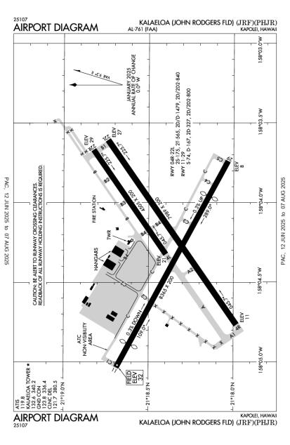
Runway 11/29
Dimensions:
8,365 × 200 ft
(2,550 × 61 m)
(2,550 × 61 m)
Weight Bearing Cap:
Single wheel: 74,000 lbs
Double wheel: 167,000 lbs
Double tandem: 327,000 lbs
Dual double tandem: 800,000 lbs
Double wheel: 167,000 lbs
Double tandem: 327,000 lbs
Dual double tandem: 800,000 lbs
Surface:
asphalt, no surface treatment, in fair condition
Runway Edge Lights:
Medium
Comments:
Gross Wt (In Thsds) Single-Tandem: 189.
FAA
| Designator: | 11 | 29 |
| Elevation: | 32.3 ft | 8.3 ft |
| Heading: | 107° magnetic 118° true | 287° magnetic 298° true |
| Gradient: | 0.29% down | 0.29% up |
| Traffic Pattern: | Left Pattern | Not provided. Assume LEFT traffic pattern |
| Markings: | basic, in Fair condition | basic, in Fair condition |
| Approach Lighting: |
|
|
| Displaced Threshold: | 939 ft | 1,429 ft |
| ILS/LOC: | n/a | n/a |
| Obstructions: | n/a | n/a |
| Comments: | Large Acft Requesting Rwy 11 Can Expect Right Traffic. FAA Ots Indefly. FAA | Ots Indefly. FAA |
Runway 04R/22L
Dimensions:
7,989 × 200 ft
(2,435 × 61 m)
(2,435 × 61 m)
Weight Bearing Cap:
n/a
Surface:
asphalt, no surface treatment, in fair condition
Runway Edge Lights:
Medium
Comments:
n/a
| Designator: | 04R | 22L |
| Elevation: | 11.4 ft | 26.7 ft |
| Heading: | 044° magnetic 055° true | 224° magnetic 235° true |
| Gradient: | 0.19% up | 0.19% down |
| Traffic Pattern: | Not provided. Assume LEFT traffic pattern | Not provided. Assume LEFT traffic pattern |
| Markings: | precision, in Fair condition | basic, in Fair condition |
| Approach Lighting: |
|
|
| Displaced Threshold: | n/a | n/a |
| ILS/LOC: | n/a | n/a |
| Obstructions: | n/a | n/a |
| Comments: | Ots Indefly. FAA | Ots Indefly. FAA |
Runway 04L/22R
Dimensions:
4,505 × 200 ft
(1,373 × 61 m)
(1,373 × 61 m)
Weight Bearing Cap:
n/a
Surface:
asphalt, no surface treatment, in fair condition
Runway Edge Lights:
Medium
Comments:
n/a
| Designator: | 04L | 22R |
| Elevation: | 21.4 ft | 28.7 ft |
| Heading: | 044° magnetic 055° true | 224° magnetic 235° true |
| Gradient: | 0.16% up | 0.16% down |
| Traffic Pattern: | Not provided. Assume LEFT traffic pattern | Not provided. Assume LEFT traffic pattern |
| Markings: | basic, in Fair condition | basic, in Fair condition |
| Approach Lighting: |
|
|
| Displaced Threshold: | n/a | n/a |
| ILS/LOC: | n/a | n/a |
| Obstructions: | n/a | n/a |
| Comments: | Ots Indefly. FAA | Ots Indefly. FAA |
TFRs
Location: JRF
Please verify all content below using the FAA TFR Search Site or with a flight briefer.
TFR count: 0
NOTAMs
Location: JRF
Please verify all content below using the FAA NOTAM Search Site or with a flight briefer.
NOTAM count: 29 (Partial list shown. Expand to see full list HERE.)
| Number: | Start Date: (UTC) | End Date: (UTC) | Condition: |
|---|---|---|---|
| 05/026 | 05/23/2025 2344 | 09/01/2025 0300 | AD AP CLSD TO LDG AND TKOF EXC ACFT WINGSPAN LESS THAN 214FT |
| 05/029 | 05/27/2025 1619 | 07/31/2025 2200 | OBST STACK (ASN UNKNOWN) 211817N1580535W (0.62NM W JRF) 189FT (189FT AGL) U/S |
| 05/025 | 05/23/2025 2345 | 09/01/2025 0300 | AD AP ALL SFC WIP MAINT |
| 05/020 | 05/23/2025 2309 | 09/01/2025 0300 | RWY 04R ALL DIST REMAINING LGT U/S |
| 05/008 | 05/23/2025 2010 | 09/01/2025 1000 | TWY C BTN RWY 04R/22L AND TWY C5 CLSD |
| 05/003 | 05/04/2025 0458 | 12/16/2025 1703 | RWY 11/29 CLSD DLY SS-SR |
| 06/009 | 07/07/2025 0615 | 12/26/2025 0745 | AIRSPACE LGT OUT TRG WI AN AREA DEFINED AS 3NM RADIUS OF JRF SFC-2000FT AVOIDANCE ADZ MON-FRI 0615-0745 |
| 05/024 | 05/23/2025 2324 | 09/01/2025 0300 | TWY ALL EDGE LGT NOT STD |
Additional Remarks
Avoid Overflight Refineries West of Arpt, Gaseous Exhaust Plumes and Flames May Rise to 267 Ft AGL Without Warning.
Source:
FAA
Federal Aviation Administration
Military Helicopter Operations on & In vicinity of Airport Due to Uscg Military Helipad Near Ry 04R.
Source:
FAA
Federal Aviation Administration
Navair 0800 R-14 Natops US Navy Aircraft Firefighters and Rescue Manual, Category II Airfield (Arff Index B Equivalent).
Source:
FAA
Federal Aviation Administration
Ocnl Bird Haz Approach End Ry 04L and Ry 04R.
Source:
FAA
Federal Aviation Administration
Potential Hydroplaning All Acft Due Standing Water At Intxn Ry 04R and Ry 11.
Source:
FAA
Federal Aviation Administration
Tsnt Acft CTC FBO for Fuel 808-490-2400.
Source:
FAA
Federal Aviation Administration
Noise Abatement
Instrument Procedures
Data Cycle:
Operations & More Information
Lat/Long:
- 21.30713, -158.07044
- 21° 18′ 25.7″ N, 158° 4′ 13.6″ W
- 21° 18.428′ N, 158° 4.227′ W
ARTCC:
Honolulu Control Facility (ZHN)
App/Depart Control Facility:
HNL
Chart:
NACO: Hawaiian Islands Sectional
FSS:
Honolulu (HNL)
1-800-WX-BRIEF
1-800-WX-BRIEF
Wind Indicator:
Lighted
Mag Var:
11E (1985)
NOTAM Facility:
Seg Circle:
Yes
Beacon:
Present
Lighting:
When Air Traffic Control Tower Clsd Actvt MIRL Rwy 04R/22L; MIRL Rwy 04L/22R; MIRL Rwy 11/29; Twy Lights - CTAF. PAPI Rwys 04L, 04R, 11, 22L, 22R, & 29 Oper Consly.
FAA
Pattern Altitude:
Small Acft 800 Ft, Large Acft 1000 Ft.
FAA
Special Operations:
Communications Card
| Type: | Frequency / Phone: | Sector / Comments: | Call Sign: |
|---|---|---|---|
| Approach/Departure | 118.3 | Hcf Approach | |
| ASOS | 119.8T (808) 752-3876 | Kalaeloa | |
| ATIS | 119.8 | Kalaeloa | |
| Clearance Delivery | 121.7 | Kalaeloa | |
| CTAF | 132.6 | Kalaeloa | |
| Emergency | 121.5 | Kalaeloa | |
| Ground Control | 123.8 | Kalaeloa | |
| Tower | 132.6 | Kalaeloa |
Navaids
Services
Fuel:
100LL Low-Lead, Jet A, Jet A1
AM
Engine Repair:
None
Airframe Repair:
None
Bottled Oxygen:
None
Bulk Oxygen:
None
Customs:
None
Transportation:
None Reported
AM
Activities:
None Reported
Camping On Field:
None Reported
Aircraft & Activity
Webcams
METARs
TAFs
Contact Addresses
Airport Manager
Malcom Smith
Honolulu, HI 96819-1897
(808) 836-6533 (Office)
Owner
Hawaii State Airports Division
Honolulu, HI 96819-1880
(808) 838-8600 (Office)
Airport Reviews
Overall:
1 rating | 2 reviews
Runways and Taxiways:No ratings
Markings and Signage:No ratings
Ground Transportation:No ratings
Sort By:
- 9/30/19Nick J.As someone who was formerly looking for a flight school out of PHNL, PHJR is a much easier airport to take those first couple steps into the aviation world out of. The Right Flight Services has been an amazing flight school to learn from, and the FBO…
- 2/20/16RAY R.Disappointed with the treatment received by the local flight school (Barbers Point Flight School) during a recent visit to the FBO. The manager present (Marleen) was pleasant, nice and knowledgeable. I was hoping to fly several practice approaches in…