FAA Information Effective: Jul 10, 2025
All information is provided from the FAA unless otherwise noted.
(KPLD) Portland Municipal Airport
No ratings | 1 review
Overview
Attendance:
Attended
Year-round,Mon-Sat/0800-1900
FAA
Runways:
09/27
Runway length: 5,505 ft (1,678 m)
Elevation:
925 ft (Surveyed)
Tower:
No
Airspace:
Unknown
Fees:
Hangar, Landing, Ramp, Tie Down, Other
Click FBO link(s) below for details:
Click FBO link(s) below for details:
FBO Fee Details:
City of PortlandTimezone:
EDT (UTC-04:00)
Sunrise-Sunset:
6:32 am - 9:03 pm
Evening-Morning Civil Twilight:
9:34 pm
(Today)
(Today)
-
6:01 am
(Tomorrow)
(Tomorrow)
Minimum Fuel Prices:
$5.25
100LL (full)
$5.25
100LL (self)
$4.89
Jet-A-Premix/Prist (full)
$4.89
Jet-A-Premix/Prist (self)
Runway
Satellite
Sectional
FBOs
Submit New FBO
City of Portland
No ratings | Be the first to review this business
Services Offered:
$5.25 | 100LL | full
$5.25 | 100LL | self
$4.89 | Jet-A-Premix/Prist | full
$4.89 | Jet-A-Premix/Prist | self
Location:
On field: N
Phone:
(260) 729-5233
Freq. Monitored:
Fees:
Hangar, Landing, Ramp, Tie Down, Other
Flight Training
Submit New Flight School
Other businesses
Submit New Business
AOPA Travel Discounts 
FlightBridge is the ultimate all-in-one travel booking platform built for the general aviation community. AOPA Members receive free access to FlightBridge with AOPA discounted rates automatically applied. Members save an average of 30% on hotel bookings! Learn more about FlightBridge HERE.
Local Food/Lodging/Activities
Local Attractions
Local Activities
Restaurants
Hotels and Lodging
Travel Discounts
Flying Clubs
Submit New Flying Club
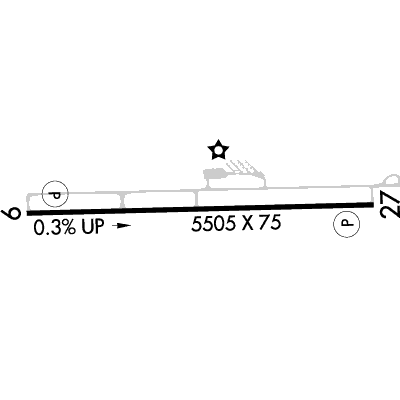
Runway 09/27
Dimensions:
5,505 × 75 ft
(1,678 × 23 m)
(1,678 × 23 m)
Weight Bearing Cap:
Single wheel: 13,000 lbs
Surface:
asphalt, aggregate friction seal coat, in good condition
Runway Edge Lights:
Medium
Comments:
n/a
| Designator: | 09 | 27 |
| Elevation: | 907.1 ft | 925.3 ft |
| Heading: | 092° magnetic 089° true | 272° magnetic 269° true |
| Gradient: | 0.33% up | 0.33% down |
| Traffic Pattern: | Left Pattern | Left Pattern |
| Markings: | non-precision, in Fair condition | non-precision, in Fair condition |
| Approach Lighting: |
|
|
| Displaced Threshold: | n/a | n/a |
| ILS/LOC: | n/a | n/a |
| Obstructions: | n/a | Power-Line, Both-Sides, 24 ft high, 950 ft from end, 31:1 clearance slope |
| Comments: | Seasonal Crops. FAA | Papi Unusbl Byd 3 Degs Right of Cntrln. FAA |
TFRs
Location: PLD
Please verify all content below using the FAA TFR Search Site or with a flight briefer.
TFR count: 0
NOTAMs
Location: PLD
Please verify all content below using the FAA NOTAM Search Site or with a flight briefer.
NOTAM count: 9 (Partial list shown. Expand to see full list HERE.)
| Number: | Start Date: (UTC) | End Date: (UTC) | Condition: |
|---|---|---|---|
| 06/365 | 06/14/2025 1816 | 07/29/2025 1815 | OBST TOWER LGT (ASN 2023-AGL-20329-OE) 402137N0850240W (6.0NM SSW PLD) 1245FT (255FT AGL) U/S |
| 07/238 | 07/09/2025 0405 | 10/07/2025 0400 | OBST TOWER LGT (ASR 1224503) 402122.80N0850828.80W (8.9NM SW PLD) 1247.7FT (264.8FT AGL) U/S |
| 07/586 | 07/17/2025 1705 | 08/29/2025 2300 | SVC AUTOMATED WX BCST SYSTEM DP/WX UNREL |
| 05/667 | 05/23/2025 1635 | 08/21/2025 0400 | OBST TOWER LGT (ASR 1028131) 402448.00N0850109.00W (2.6NM SSW PLD) 1226.0FT (297.9FT AGL) U/S |
| 07/844 | 07/23/2025 0517 | 08/07/2025 0417 | OBST TOWER LGT (ASR 1222319) 402641.50N0850855.60W (7.2NM W PLD) 1178.1FT (283.1FT AGL) U/S |
| 05/548 | 05/19/2025 1202 | RWY 09 RWY END ID LGT NOT STD | |
| 5/2777 | 07/04/2025 2024 | IAP PORTLAND MUNI, PORTLAND, IN.
RNAV (GPS) RWY 27, AMDT 2A...
MISSED APPROACH: CLIMB TO 2700 DIRECT DIYEC A… | |
| 06/840 | 06/28/2025 0710 | 08/12/2025 0710 | OBST TOWER LGT (ASN 2018-AGL-15377-OE) 403818N0845723W (11.4NM NE PLD) 1202FT (340FT AGL) U/S |
Additional Remarks
150 Ft Lgtd Water Twr 1300 Ft Se; 120 Ft Grain Elev 1300 Ft Ese.
Source:
FAA
Federal Aviation Administration
For Clearance Delivery Contact Chicago ARTCC at 630-906-8921.
Source:
FAA
Federal Aviation Administration
Noise Abatement
Instrument Procedures
Data Cycle:
Operations & More Information
Lat/Long:
- 40.45152, -84.99172
- 40° 27′ 5.5″ N, 84° 59′ 30.2″ W
- 40° 27.091′ N, 84° 59.503′ W
ARTCC:
Chicago (ZAU)
App/Depart Control Facility:
FWA
Chart:
NACO: Detroit Sectional
FSS:
Terre Haute (HUF)
1-800-WX-BRIEF
1-800-WX-BRIEF
Wind Indicator:
Lighted
Mag Var:
03W (1985)
NOTAM Facility:
Seg Circle:
Yes
Beacon:
Present
Lighting:
Pilot Activated Lighting:
- low intensity: 3 clicks in 3 secs
- medium intensity: 5 clicks in 5 secs
- high intensity: 7 clicks in 7 secs
AM
Actvt REIL Rwy 09 & 27; MIRL Rwy 09/27 - CTAF. MIRL Rwy 09/27 Preset Low Intst; Incr Int - CTAF. PAPI Rwy 09 & 27 on Consly.
FAA
Pattern Altitude:
No data provided. Assume 1000 AGL.
Special Operations:
Communications Card
| Type: | Frequency / Phone: | Sector / Comments: | Call Sign: |
|---|---|---|---|
| Approach/Departure | 132.15 | SE/NE OF ACTIVE RWY | Fort Wayne |
| Approach/Departure | 127.2 | SW/NW OF ACTIVE RWY | Fort Wayne |
| AWOS-3 | 124.675T (260) 726-7882 | ||
| Clearance Delivery Phone | (630) 906-8921 | Chicago ARTCC | |
| CTAF | 122.8 | ||
| UNICOM | 122.8 |
Navaids
Services
Fuel:
100LL Low-Lead, Jet A
AM
Engine Repair:
None
Airframe Repair:
None
Bottled Oxygen:
None
Bulk Oxygen:
None
Customs:
None
Transportation:
Courtesy Transportation
AM
Activities:
None Reported
Camping On Field:
None Reported
Aircraft & Activity
Webcams
METARs
TAFs
Contact Addresses
Airport Manager
Harold Tavzel
Portland, IN 47371
(260) 729-1577 (Office)
Owner
City of Portland
Portland, IN 47371
(260) 729-5233 (Office)
Airport Reviews
Overall:
No ratings | 1 review
Runways and Taxiways:No ratings
Markings and Signage:No ratings
Ground Transportation:No ratings
Sort By:
- 6/10/16PIERRE O.STOPPED THERE ON JUNE 8, 2016 TO STRETCH MY LEGS AND ATTEND TO NATURE. ALL THE PEOPLE THERE WAVED AT ME AND APPEAR FRIENDLY. AT THE FBO, A CHAP SPOKE WITH ME AND SHOWED GENERAL INTEREST IN WHAT I WAS DOING. I DID NOT NEED ANYTHING; BUT I AM SURE THAT…