FAA Information Effective: Jul 10, 2025
All information is provided from the FAA unless otherwise noted.
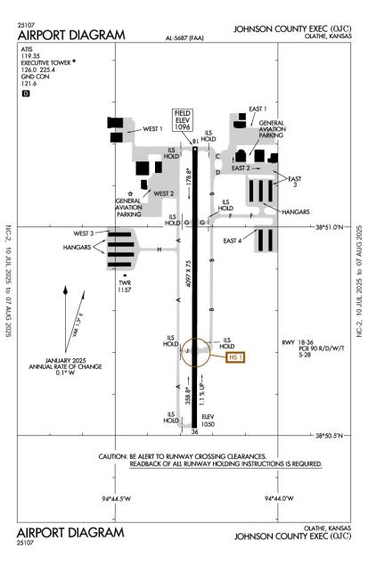
(KOJC) Johnson County Exec Airport
1 rating | 2 reviews
Olathe, KS
(913) 715-6002
Overview
Attendance:
Attended
Year-round, 7 Days a Week,All
FAA
Runways:
18/36
Runway length: 4,097 ft (1,249 m)
Elevation:
1,096 ft (Surveyed)
Tower:
Tower Hrs: 0700-2100
FAA
Airspace:
CLASS D SVC 0700-2100; OTHER TIMES CLASS G
FAA
Fees:
Hangar, Landing, Overnight, Tie Down, Other
Click FBO link(s) below for details:
KCAC Aviation
Click FBO link(s) below for details:
FBO Fee Details:
Executive Aircraft ServiceKCAC Aviation
Timezone:
CDT (UTC-05:00)
Sunrise-Sunset:
6:15 am - 8:37 pm
Evening-Morning Civil Twilight:
9:08 pm
(Today)
(Today)
-
5:45 am
(Tomorrow)
(Tomorrow)
Minimum Fuel Prices:
$6.25
100LL (full)
$4.89
Jet-A-Premix/Prist (full)
Runway
Satellite
Sectional
FBOs
Submit New FBO
Executive Aircraft Service
No ratings | Be the first to review this business
Services Offered:
Car Rental
$6.25 | 100LL | full
$4.89 | Jet-A-Premix/Prist | full
Location:
Olathe, KS
Phone:
(913) 261-8345
Freq. Monitored:
UNICOM: 122.95
Fees:
Overnight, Other
KCAC Aviation
2 ratings | 2 reviews
Services Offered:
Maintenance
Car Rental
Sales
$6.50 | 100LL | full
$6.25 | Jet-A-Premix/Prist | full
Location:
On field: NW
Phone:
(913) 782-0530
Freq. Monitored:
UNICOM: 131.5
ASRI: 131.5
ASRI: 131.5
Fees:
Hangar, Landing, Tie Down, Other
Flight Training
Submit New Flight School
Other businesses
Submit New Business
AOPA Travel Discounts 
FlightBridge is the ultimate all-in-one travel booking platform built for the general aviation community. AOPA Members receive free access to FlightBridge with AOPA discounted rates automatically applied. Members save an average of 30% on hotel bookings! Learn more about FlightBridge HERE.
Local Food/Lodging/Activities
Local Attractions
Local Activities
Restaurants
Hotels and Lodging
Travel Discounts
Runway 18/36
Dimensions:
4,097 × 75 ft
(1,249 × 23 m)
(1,249 × 23 m)
Weight Bearing Cap:
Single wheel: 28,000 lbs
Surface:
concrete, no surface treatment, in excellent condition
Runway Edge Lights:
Medium
Comments:
Pcr Value: 90/R/D/W/T
FAA
| Designator: | 18 | 36 |
| Elevation: | 1,096.3 ft | 1,050.2 ft |
| Heading: | 176° magnetic 180° true | 0-4° magnetic 000° true |
| Gradient: | 1.13% down | 1.13% up |
| Traffic Pattern: | Left Pattern | Left Pattern |
| Markings: | non-precision, in Good condition | non-precision, in Good condition |
| Approach Lighting: |
|
|
| Displaced Threshold: | n/a | n/a |
| ILS/LOC: | LOC/DME | Localizer |
| Obstructions: | n/a | Trees, 155 ft Left ft of center, 34 ft high, 901 ft from end, 20:1 clearance slope |
| Comments: | n/a | n/a |
TFRs
Location: OJC
Please verify all content below using the FAA TFR Search Site or with a flight briefer.
TFR count: 0
NOTAMs
Location: OJC
Please verify all content below using the FAA NOTAM Search Site or with a flight briefer.
NOTAM count: 5
| Number: | Start Date: (UTC) | End Date: (UTC) | Condition: |
|---|---|---|---|
| 4/4229 | 03/29/2024 2000 | 03/19/2026 0900 | STAR JOHNSON COUNTY EXEC, OLATHE, KS BRAYMER EIGHT
ARRIVAL..PROCEDURE AMEND SPINNER TRANSITION, MOCA 2700 SP… |
| 5/4730 | 04/10/2025 1222 | IAP JOHNSON COUNTY EXEC, OLATHE, KS.
LOC RWY 36, AMDT 2...
CHANGE CHART NOTE TO READ: FOR INOPERATIVE ALS, I… | |
| 5/4729 | 04/10/2025 1216 | IAP JOHNSON COUNTY EXEC, OLATHE, KS.
RNAV (GPS) RWY 18, AMDT 1C...
LNAV VIS CAT C 1 3/8.
2504101216-27041012… | |
| 5/4731 | 04/10/2025 1227 | IAP JOHNSON COUNTY EXEC, OLATHE, KS.
LOC RWY 18, AMDT 8A...
ADD CHART NOTE: RWY 18 HELICOPTER VISIBILITY RED… | |
| 07/008 | 07/14/2025 1200 | 12/31/2025 2300 | APRON WEST 3 APN TXL M AND N HANGARS CLSD CONST S SIDE LGTD AND BARRICADED |
Additional Remarks
Birds, Waterfowl, Wildlife on & In vicinity of Arpt.
Source:
FAA
Federal Aviation Administration
For Cd When Air Traffic Control Tower is Clsd CTC Mci Approach at 816-329-2710.
Source:
FAA
Federal Aviation Administration
It is Advised That Rotocraft Avoid the Overflights of Surrounding Neighborhoods.
Source:
FAA
Federal Aviation Administration
To Confirm Snow Removal and Winter Conditions Nov-Apr Call 913-715-6005.
Source:
FAA
Federal Aviation Administration
Upon Takeoff for Rys 18 & 36 Maintain Ry Heading Until Passing 1,600 Ft MSL.
Source:
FAA
Federal Aviation Administration
Noise Abatement
Instrument Procedures
Data Cycle:
Operations & More Information
Lat/Long:
- 38.84760, -94.73758
- 38° 50′ 51.4″ N, 94° 44′ 15.3″ W
- 38° 50.856′ N, 94° 44.255′ W
ARTCC:
Kansas City (ZKC)
App/Depart Control Facility:
MCI
Chart:
NACO: Kansas City Sectional
FSS:
Columbia (COU)
1-800-WX-BRIEF
1-800-WX-BRIEF
Wind Indicator:
Lighted
Mag Var:
04E (2000)
NOTAM Facility:
Seg Circle:
No
Beacon:
Present
Lighting:
When Air Traffic Control Tower Clsd, Actvt MALSR Rwy 36; PAPI Rwy 18; MIRL Rwy 18-36; Twy Lgts; and Wind Cone - CTAF. VASI Rwy 36 Opr Consly.
FAA
Pattern Altitude:
TPA Low Per Acft 1000 Ft AGL, High Per Acft 1500 Ft AGL
FAA
TPA: 1000 Ft AGL
FAA
Special Operations:
Communications Card
| Type: | Frequency / Phone: | Sector / Comments: | Call Sign: |
|---|---|---|---|
| Approach/Departure | 118.9 | Kansas City | |
| ASOS | (913) 780-6969 | Executive | |
| ATIS | 119.35 | Executive | |
| BRAYMER STAR | 120.95 | Kansas City | |
| CTAF | 126.0 | Executive | |
| Ground Control | 121.6 | Executive | |
| JHAWK STAR | 120.95 | Kansas City | |
| Tower | 126.0 | Executive | |
| TYGER STAR | 120.95 | Kansas City | |
| UNICOM | 122.95 | Executive |
Navaids
Services
Fuel:
100LL Low-Lead, Jet A
AM
Engine Repair:
Major
AM
Airframe Repair:
Major
AM
Bottled Oxygen:
Low
AM
Bulk Oxygen:
Low
AM
Customs:
None
Transportation:
Courtesy Transportation
AM
Activities:
Intensive Flight Training
AM
Camping On Field:
None Reported
Aircraft & Activity
Webcams
METARs
METARs from this airport:
METARs from nearby reporting stations:
TAFs
TAFs from nearby airports:
KIXD TAF
7 nm W
Issued:
9:59 PM GMT
(an hour ago)
Today 10:00 PM - Tomorrow 12:00 AM GMT
Vis:
6
SM
Wind:
@
5
KT
Cld:
- Broken clouds 3500' AGL
- Overcast 10000' AGL
Wx:
Light Rainshowers
Today 10:00 PM - Tomorrow 12:00 AM GMT
TEMPO
Vis:
3
SM
Wind:
@
5
KT
Cld:
- Broken clouds 2500' AGL
Wx:
Light Rainshowers
Tomorrow 12:00 AM - 4:00 AM GMT
Vis:
6
SM
Wind:
VRB
@
6
KT
Cld:
- Broken clouds 3000' AGL
Wx:
Thunderstorm, Light Rain
Tomorrow 4:00 AM - 6:00 PM GMT
KMKC TAF
18 nm N
Issued:
9:01 PM GMT
(2 hours ago)
Today 9:00 PM - 10:00 PM GMT
Today 10:00 PM - Tomorrow 2:00 AM GMT
Vis:
6+
SM
Wind:
VRB
@
6
KT
Cld:
- Scattered clouds 2500' AGL
Wx:
N/A
Today 10:00 PM - Tomorrow 2:00 AM GMT
TEMPO
Vis:
4
SM
Wind:
VRB
@
6
KT
Cld:
- Broken clouds 2500' AGL
Wx:
Thunderstorm, Rain
Tomorrow 2:00 AM - 5:00 AM GMT
Vis:
6
SM
Wind:
VRB
@
6
KT
Cld:
- Broken clouds 3000' AGL
Wx:
Thunderstorm, Light Rain
Tomorrow 5:00 AM - 6:00 PM GMT
KMCI TAF
27 nm N
Issued:
8:19 PM GMT
(3 hours ago)
Today 8:00 PM - 9:00 PM GMT
Vis:
6+
SM
Wind:
@
7
KT
Cld:
- Scattered clouds 1900' AGL
- Broken clouds 10000' AGL
Wx:
N/A
Today 9:00 PM - Tomorrow 1:00 AM GMT
Vis:
6+
SM
Wind:
VRB
@
6
KT
Cld:
- Scattered clouds 2000' AGL
Wx:
N/A
Today 9:00 PM - Tomorrow 1:00 AM GMT
TEMPO
Vis:
4
SM
Wind:
VRB
@
6
KT
Cld:
- Broken clouds 2000' AGL
Wx:
Thunderstorm, Rain
Tomorrow 1:00 AM - 5:00 AM GMT
Vis:
6
SM
Wind:
VRB
@
6
KT
Cld:
- Broken clouds 3000' AGL
Wx:
Thunderstorm, Light Rain
Tomorrow 5:00 AM - 6:00 PM GMT
KFOE TAF
43 nm W
Issued:
9:05 PM GMT
(2 hours ago)
Today 9:00 PM - 11:00 PM GMT
Vis:
6+
SM
Wind:
@
6
KT
Cld:
- Scattered clouds 3500' AGL
- Broken clouds 10000' AGL
Wx:
Showers in vicinity
Today 9:00 PM - 11:00 PM GMT
TEMPO
Today 11:00 PM - Tomorrow 3:00 AM GMT
Vis:
4
SM
Wind:
@
5
KT
Cld:
- Broken clouds 3000' AGL
Wx:
Rainshowers, Thunderstorm in vicinity
Tomorrow 3:00 AM - 6:00 AM GMT
Vis:
6
SM
Wind:
VRB
@
5
KT
Cld:
- Overcast 8000' AGL
Wx:
Light Rainshowers
Tomorrow 3:00 AM - 6:00 AM GMT
PROB30
Vis:
4
SM
Wind:
Cld:
- Overcast 2500' AGL
Wx:
Thunderstorm, Rain
Tomorrow 6:00 AM - 3:00 PM GMT
Tomorrow 6:00 AM - 10:00 AM GMT
PROB30
Vis:
4
SM
Wind:
Cld:
- Overcast 2500' AGL
Wx:
Thunderstorm, Rain
Tomorrow 3:00 PM - 6:00 PM GMT
Vis:
6+
SM
Wind:
@
6
KT
Cld:
- Scattered clouds 14000' AGL
Wx:
N/A
KTOP TAF
44 nm W
Issued:
9:06 PM GMT
(2 hours ago)
Today 9:00 PM - 11:00 PM GMT
Vis:
6+
SM
Wind:
@
6
KT
Cld:
- Scattered clouds 3500' AGL
- Broken clouds 10000' AGL
Wx:
Showers in vicinity
Today 9:00 PM - 11:00 PM GMT
TEMPO
Vis:
4
SM
Wind:
@
6
KT
Cld:
- Overcast 2500' AGL
Wx:
Rainshowers
Today 11:00 PM - Tomorrow 3:00 AM GMT
Vis:
4
SM
Wind:
@
5
KT
Cld:
- Broken clouds 3000' AGL
Wx:
Rainshowers, Thunderstorm in vicinity
Tomorrow 3:00 AM - 6:00 AM GMT
Vis:
6
SM
Wind:
VRB
@
5
KT
Cld:
- Overcast 8000' AGL
Wx:
Light Rainshowers
Tomorrow 3:00 AM - 6:00 AM GMT
PROB30
Vis:
4
SM
Wind:
Cld:
- Overcast 2500' AGL
Wx:
Thunderstorm, Rain
Tomorrow 6:00 AM - 4:00 PM GMT
Tomorrow 6:00 AM - 10:00 AM GMT
PROB30
Vis:
4
SM
Wind:
Cld:
- Overcast 2500' AGL
Wx:
Thunderstorm, Rain
Tomorrow 4:00 PM - 6:00 PM GMT
Vis:
6+
SM
Wind:
@
6
KT
Cld:
- Scattered clouds 14000' AGL
Wx:
N/A
Contact Addresses
Airport Manager
Bryan Johnson
New Century, KS 66031
(913) 715-6002 (Office)
Owner
Johnson County
Olathe, KS 66031
(913) 715-6000 (Office)
Airport Reviews
Overall:
1 rating | 2 reviews
Runways and Taxiways:No ratings
Markings and Signage:No ratings
Ground Transportation:No ratings
Sort By:
- 3/17/25CHARLES B.Executive Aircraft Svc on the east side of OJC was friendly and helpful, and their facilities are immaculate. Gas was $5.50/gal, no tiedown fee for overnight ramp parking (I bought 40g of gas). I recommend them without reservation.
- 11/23/14JAY L.STAY AWAY from AIR ASSOCIATES OF KANSAS located at Johnson County Executive Airport (OJC). On Sat., Oct. 4, 2014, they charged me $865 to replace one tire and inner tube on my Columbia 400 (single engine, fixed gear, piston airplane). It is ethically…
Nearby Events
- airshow2025 Water Follies Apollo Columbia Cup & STCU Over-the-River Air Show07/25/2025 - 07/27/2025Location: Columbia Park
 Description:The Tri-City Water Follies is delighted to announce that the Apollo Columbia Cup and STCU Over-the-River Air Show will be held on July 25 - 27, 2025.