FAA Information Effective: Jul 10, 2025
All information is provided from the FAA unless otherwise noted.
(KRBW) Lowcountry Regional Airport
1 rating | 2 reviews
Walterboro, SC
(843) 955-0290
Overview
Attendance:
Attended
Year-round, 7 Days a Week,0830-1800
FAA
Elevation:
101 ft (Surveyed)
Tower:
No
Airspace:
Unknown
Fees:
Ramp, Tie Down, Other
Click FBO link(s) below for details:
Click FBO link(s) below for details:
FBO Fee Details:
Lowcountry Regional AirportTimezone:
EDT (UTC-04:00)
Sunrise-Sunset:
6:29 am - 8:30 pm
Evening-Morning Civil Twilight:
8:57 pm
(Today)
(Today)
-
6:03 am
(Tomorrow)
(Tomorrow)
Minimum Fuel Prices:
$7.27
100LL (full)
$6.19
100LL (self)
$5.66
Jet-A-Premix/Prist (full)
Runway
Satellite
Sectional
FBOs
Submit New FBO
Lowcountry Regional Airport
1 rating | 1 review
Services Offered:
Car Rental
$7.27 | 100LL | full
$6.19 | 100LL | self
$5.66 | Jet-A-Premix/Prist | full
Location:
On field: SE
Phone:
(843) 549-2549
Freq. Monitored:
UNICOM: 122.8
ASRI: 129.7
ASRI: 129.7
Fees:
Ramp, Tie Down, Other
Flight Training
Submit New Flight School

Other businesses
Submit New Business
AOPA Travel Discounts 
FlightBridge is the ultimate all-in-one travel booking platform built for the general aviation community. AOPA Members receive free access to FlightBridge with AOPA discounted rates automatically applied. Members save an average of 30% on hotel bookings! Learn more about FlightBridge HERE.
Local Food/Lodging/Activities
Local Attractions
Local Activities
Restaurants
Hotels and Lodging
Travel Discounts
Tuskegee Airmen Memorial
RBW
Walterboro Wings-n-Wheels
Tuskegee Airmen Memorial
Flying Clubs
Submit New Flying Club
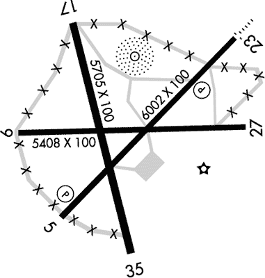
Runway 05/23
Dimensions:
6,002 × 100 ft
(1,829 × 30 m)
(1,829 × 30 m)
Weight Bearing Cap:
Single wheel: 70,000 lbs
Double wheel: 101,000 lbs
Double wheel: 101,000 lbs
Surface:
asphalt, concrete, no surface treatment, in good condition
Runway Edge Lights:
Medium
Comments:
n/a
| Designator: | 05 | 23 |
| Elevation: | 89.4 ft | 100.9 ft |
| Heading: | 049° magnetic 044° true | 229° magnetic 224° true |
| Gradient: | 0.19% up | 0.19% down |
| Traffic Pattern: | Left Pattern | Left Pattern |
| Markings: | non-precision, in Good condition | precision, in Good condition |
| Approach Lighting: |
|
|
| Displaced Threshold: | n/a | n/a |
| ILS/LOC: | n/a | ILS/DME |
| Obstructions: | Trees, 265 ft Right ft of center, 82 ft high, 1,999 ft from end, 21:1 clearance slope | Trees, 823 ft Left ft of center, 83 ft high, 2,527 ft from end, 28:1 clearance slope |
| Comments: | n/a | n/a |
Runway 17/35
Dimensions:
5,705 × 100 ft
(1,739 × 30 m)
(1,739 × 30 m)
Weight Bearing Cap:
Single wheel: 34,000 lbs
Double wheel: 51,000 lbs
Double wheel: 51,000 lbs
Surface:
asphalt, concrete, no surface treatment, in excellent condition
Runway Edge Lights:
n/a
Comments:
n/a
| Designator: | 17 | 35 |
| Elevation: | 82.3 ft | 91.6 ft |
| Heading: | 171° magnetic 166° true | 351° magnetic 346° true |
| Gradient: | 0.16% up | 0.16% down |
| Traffic Pattern: | Left Pattern | Left Pattern |
| Markings: | non-precision, in Good condition | non-precision, in Good condition |
| Approach Lighting: | n/a | n/a |
| Displaced Threshold: | n/a | n/a |
| ILS/LOC: | n/a | n/a |
| Obstructions: | Tree, 74 ft Left ft of center, 17 ft high, 233 ft from end, 1:1 clearance slope | Tree, 43 ft Left ft of center, 57 ft high, 2,370 ft from end, 38:1 clearance slope |
| Comments: | n/a | n/a |
TFRs
Location: RBW
Please verify all content below using the FAA TFR Search Site or with a flight briefer.
TFR count: 0
NOTAMs
Location: RBW
Please verify all content below using the FAA NOTAM Search Site or with a flight briefer.
NOTAM count: 9 (Partial list shown. Expand to see full list HERE.)
| Number: | Start Date: (UTC) | End Date: (UTC) | Condition: |
|---|---|---|---|
| 05/112 | 05/08/2025 1842 | 09/05/2025 1842 | OBST TOWER LGT (ASR 1046314) 325448.40N0804120.10W (2.5NM W RBW) 329.7FT (263.8FT AGL) U/S |
| 07/225 | 07/14/2025 0147 | 07/29/2025 0047 | OBST TOWER LGT (ASR 1063278) 324301.00N0803650.00W (12.3NM S RBW) 340.6FT (319.9FT AGL) U/S |
| 04/345 | 04/23/2025 1309 | 07/23/2025 2359 | AD AP WILDLIFE HAZARD INCREASED DEER ACT |
| 07/267 | 07/16/2025 0433 | 07/31/2025 0333 | OBST TOWER LGT (ASR 1063537) 324537.00N0802051.00W (17.4NM ESE RBW) 344.5FT (319.9FT AGL) U/S |
| 5/0368 | 01/03/2025 1731 | IAP LOWCOUNTRY RGNL, WALTERBORO, SC.
ILS Y OR LOC Y RWY 23, AMDT 3...
ILS Z OR LOC Z RWY 23, ORIG-A...
RNAV … | |
| 07/153 | 07/10/2025 1018 | 08/09/2025 2300 | OBST TOWER LGT (ASN 2022-ASO-39154-OE) 325039N0803843W (4.6NM S RBW) 296FT (259FT AGL) U/S |
| 07/250 | 07/15/2025 0423 | 07/30/2025 0323 | OBST TOWER LGT (ASR 1240459) 330248.60N0804828.90W (11.2NM NW RBW) 415.7FT (310.0FT AGL) U/S |
| 07/340 | 07/20/2025 2155 | 10/18/2025 0400 | OBST TOWER LGT (ASR 1047338) 324954.90N0804330.00W (6.9NM SW RBW) 535.8FT (478.7FT AGL) U/S |
Additional Remarks
(Wind Indcr) Supplry Lgtd Windcones Rwy 23 and Midfield.
Source:
FAA
Federal Aviation Administration
Deer on and In vicinity of Airport with Incr Act Drg Ngt and At Dusk and Dawn.
Source:
FAA
Federal Aviation Administration
For Clearance Delivery Contact Charleston Approach at 843 414-2832.
Source:
FAA
Federal Aviation Administration
Noise Abatement
Instrument Procedures
Operations & More Information
Lat/Long:
- 32.92104, -80.64059
- 32° 55′ 15.7″ N, 80° 38′ 26.1″ W
- 32° 55.262′ N, 80° 38.435′ W
ARTCC:
Jacksonville (ZJX)
App/Depart Control Facility:
CHS
Chart:
NACO: Charlotte Sectional
FSS:
Anderson (AND)
1-800-WX-BRIEF
1-800-WX-BRIEF
Wind Indicator:
Lighted
Mag Var:
05W (1990)
NOTAM Facility:
Seg Circle:
No
Beacon:
Present
Lighting:
Odals Rwy 23; REILs Rwy 23; PAPI Rwy 05 & 23; Mirls Rwy 05/23 - Opr Consly Fm Dusk-2200. Fm 2200 to Dawn Actvt ODALS Rwy 23; Mirls Rwy 05/23 - CTAF.
FAA
Pattern Altitude:
Light Aircraft 900 MSL
AM
Special Operations:
Communications Card
| Type: | Frequency / Phone: | Sector / Comments: | Call Sign: |
|---|---|---|---|
| Approach/Departure | 120.7 | Charleston | |
| AWOS-3PT | 118.725T (843) 538-3575 | ||
| Clearance Delivery Phone | (843) 414-2832 | Charleston Approach | |
| CTAF | 122.8 | ||
| UNICOM | 122.8 |
Navaids
Services
Fuel:
100LL Low-Lead, Jet A
AM
Engine Repair:
Major
AM
Airframe Repair:
Major
AM
Bottled Oxygen:
None
Bulk Oxygen:
None
Customs:
None
Transportation:
Courtesy Transportation
AM
Activities:
None Reported
Camping On Field:
None Reported
Aircraft & Activity
Webcams
METARs
TAFs
Contact Addresses
Airport Manager
Bert Duffie
Walterboro, SC 29488
(843) 955-0290 (Office)
Owner
City of Walterboro and Colleton County
Walterboro, SC 29488
(843) 549-2549 (Office)
Airport Reviews
Overall:
1 rating | 2 reviews
Runways and Taxiways:No ratings
Markings and Signage:No ratings
Ground Transportation:No ratings
Sort By:
- 4/18/18Howard P.Good fuel prices (I use Self Serve), helpful staff. The Hampton House Bed and Breakfast (2 miles away) will come and get you. Relaxing town of Walterboro, with very friendly locals. With 6 directions to takeoff or land on, crosswinds are rarely a…
- 6/15/15EDMOND G.Great visit going and coming on a Bahamas dive trip. Good fuel prices, multiple runway choices, not too much traffic. Stayed at a Old Academy B&B since we got in too late to keep going - lovely place and Don and Jean are wonderful. Don picked us up a…