FAA Information Effective: Jul 10, 2025
All information is provided from the FAA unless otherwise noted.
(N30) Cherry Ridge Airport
1 rating | 6 reviews
Honesdale, PA
(570) 253-5833
Overview
Attendance:
Attended
Year-round, 7 Days a Week,0900-1700
FAA
Runways:
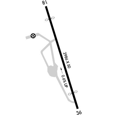
18/36
Runway length: 2,986 ft (910 m)
Elevation:
1,357 ft (Estimated)
Tower:
No
Airspace:
Unknown
Fees:
Timezone:
EDT (UTC-04:00)
Sunrise-Sunset:
5:51 am - 8:26 pm
Evening-Morning Civil Twilight:
8:58 pm
(Today)
(Today)
-
5:20 am
(Tomorrow)
(Tomorrow)
Minimum Fuel Prices:
$5.65
100LL (self)
Runway
Satellite
Sectional
FBOs
Submit New FBO
Earlynn Aviation
1 rating | 1 review
Services Offered:
$5.65 | 100LL | self
Location:
On field: CTR
Phone:
(570) 253-5833
Freq. Monitored:
Fees:
Overnight, Other
Flight Training
Submit New Flight School
Other businesses
Submit New Business
AOPA Travel Discounts 
FlightBridge is the ultimate all-in-one travel booking platform built for the general aviation community. AOPA Members receive free access to FlightBridge with AOPA discounted rates automatically applied. Members save an average of 30% on hotel bookings! Learn more about FlightBridge HERE.
Local Food/Lodging/Activities
Local Attractions
Local Activities
Restaurants
Hotels and Lodging
Travel Discounts
Flying Clubs
Submit New Flying Club
Runway 18/36
Dimensions:
2,986 × 50 ft
(910 × 15 m)
(910 × 15 m)
Weight Bearing Cap:
Single wheel: 10,000 lbs
Surface:
asphalt, no surface treatment, in fair condition
Runway Edge Lights:
Non-standard
Comments:
n/a
| Designator: | 18 | 36 |
| Elevation: | 1,346 ft | 1,329 ft |
| Heading: | 180° magnetic 167° true | 360° magnetic 347° true |
| Gradient: | 0.57% down | 0.57% up |
| Traffic Pattern: | Left Pattern | Left Pattern |
| Markings: | basic, in Good condition | basic, in Good condition |
| Approach Lighting: | n/a | n/a |
| Displaced Threshold: | 519 ft | 589 ft |
| ILS/LOC: | n/a | n/a |
| Obstructions: | Tree, 224 ft Left ft of center, 84 ft high, 1,270 ft from end, 12:1 clearance slope | Tree, 110 ft Left ft of center, 51 ft high, 259 ft from end, 1:1 clearance slope |
| Comments: | Apch Ratio 21:1 to Dthr. FAA | Apch Ratio 17:1 to Dthr. FAA |
TFRs
Location: N30
Please verify all content below using the FAA TFR Search Site or with a flight briefer.
TFR count: 0
NOTAMs
Location: N30
Please verify all content below using the FAA NOTAM Search Site or with a flight briefer.
NOTAM count: 3
| Number: | Start Date: (UTC) | End Date: (UTC) | Condition: |
|---|---|---|---|
| 3/7476 | 10/18/2023 1300 | IAP CHERRY RIDGE, HONESDALE, PA.
RNAV (GPS)-B, ORIG-A...
HELICOPTER VISIBILITY REDUCTION BELOW 1 SM NOT AUTH… | |
| 07/270 | 07/22/2025 0712 | 08/06/2025 0612 | OBST TOWER LGT (ASR 1025402) 413241.20N0752739.30W (9.5NM W N30) 2480.0FT (317.9FT AGL) U/S |
| 07/032 | 07/02/2025 0146 | 08/02/2025 0300 | OBST TOWER LGT (ASR 1231200) 414958.80N0751236.10W (19.4NM NE N30) 1839.9FT (270.0FT AGL) U/S |
Additional Remarks
For Clearance Delivery Contact Wilkes-Barre Approach at 570-655-2084.
Source:
FAA
Federal Aviation Administration
Noise Abatement
Instrument Procedures
Data Cycle:
Operations & More Information
Lat/Long:
- 41.51559, -75.25156
- 41° 30′ 56.1″ N, 75° 15′ 5.6″ W
- 41° 30.936′ N, 75° 15.094′ W
ARTCC:
New York (ZNY)
App/Depart Control Facility:
AVP
Chart:
NACO: New York Sectional
FSS:
Williamsport (IPT)
1-800-WX-BRIEF
1-800-WX-BRIEF
Wind Indicator:
Lighted
Mag Var:
13W (2005)
NOTAM Facility:
Seg Circle:
No
Beacon:
Present
Lighting:
No lighting reported.
Pattern Altitude:
No data provided. Assume 1000 AGL.
Special Operations:
Communications Card
| Type: | Frequency / Phone: | Sector / Comments: | Call Sign: |
|---|---|---|---|
| Approach/Departure | 120.95 | Wilkes-Barre | |
| Clearance Delivery Phone | (570) 655-2084 | Wilkes-Barre Approach | |
| CTAF | 122.8 | ||
| UNICOM | 122.8 |
Navaids
Services
Fuel:
100LL Low-Lead
AM
Engine Repair:
Major
AM
Airframe Repair:
Major
AM
Bottled Oxygen:
None
Bulk Oxygen:
None
Customs:
None
Transportation:
None Reported
AM
Activities:
On field restaurant/café
AM
Camping On Field:
None Reported
Aircraft & Activity
Webcams
METARs
TAFs
Contact Addresses
Airport Manager
Richard Quitoni
Honesdale, PA 18431
(570) 253-5833 (Office)
Owner
Earlynn Aviation
Honesdale, PA 18431
(570) 253-5833 (Office)
Airport Reviews
Overall:
1 rating | 6 reviews
Runways and Taxiways:No ratings
Markings and Signage:No ratings
Ground Transportation:No ratings
Sort By:
- 9/21/20Julian C.adorable tiny local airport with a top notch breakfast cafe with unbeatable views of the runway. paved runway in excellent condition if a bit narrow, the locals use the area right of 36 as a grass strip. Deer are usually on this area so use caution.
- 11/23/16KRIS A.Flew in for lunch recently. Found the airport to be a nice little country airport with cheap fuel (now self serve, $4.50/gal). Hard to find the runway from a distance from the east because of the tree line but as you get closer, the hangers on the we…
- 5/4/15ADOLFO S.The restaurant lunch menu is impeccably elegant, original and yet simply delicious. Staff is friendly. Super value, A must for those intrepid explorers.
- 4/25/15MARK M.Flew up with buddies John and Bob for breakfast on Monday April 13, 2015. This was the first time we flew up since the restaurant reopened. It is completely renovated and is now under a new management by the long time airport restaurateurs Marty and …
- 4/19/15ROBERT M.Flew in from WIngs Field (KLOM) for breakfast today. Cherry Ridge Restaurant has been reopened and refurbished by Marty and Vicki Lane. Excellent breakfast with the usual friendly service from the Lanes. The restaurant is on the second floor of the F…
- 10/11/14MICHAEL L.We flew into Cherry Ridge for lunch on Sunday 10/5/14 in a Cirrus 22 out of Wings Field. Despite arriving at 2:30, the restaurant's crew didn't rush us at all (they close at 3). They could not have been more welcoming & polite. We hurried up anyway (…
