When the screens go dark
Flying emergency approaches with an iPad
By Bruce Williams
If you use an electronic flight bag in the cockpit—and these days who doesn’t?—you probably have considered what would happen if your iPad’s battery died, or if the device overheated.
")
But what if your panel went dark and you lost all navigation information? Could you fly an emergency approach in instrument meteorological conditions, using just your iPad for guidance?
Consider the following situation.
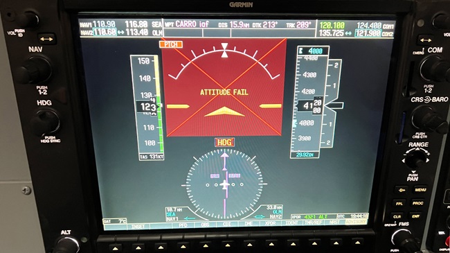
As you approach your destination of Huron, South Dakota, after a routine departure and a comfortable cruise in IMC, most of your panel abruptly goes dark. You still have basic flight instruments, including an electronic primary flight display and a horizontal situation indicator, which run on back-up batteries. Your last communications with ATC included a clearance to an initial approach fix and “expect the ILS Runway 12 approach.” But your GPS navigator, which includes navigation receivers, is now kaput, along with your second nav/com. In other words, you have no moving map or course guidance in the panel—just attitude, airspeed, altitude, and heading. You can’t even see a GPS track indicator.
The good news is, you have an iPad with a built-in GPS (or a tablet connected to an external GPS source) running ForeFlight or a similar app. The EFB confirms that your blue “own ship” symbol is tracking toward a fix at the beginning of a feeder route that takes you to the final approach course.
Of course, an iPad isn’t a “suitable RNAV system” as defined in the Aeronautical Information Manual and FAA advisory circulars, but in IMC under IFR, a situation like this qualifies as an emergency, and you can bend the rules as necessary to arrive safely.
I practice such scenarios periodically. In my Beechcraft Bonanza A36, operating under VFR with a safety pilot, I switch the navigation screen on my Garmin GTN 750Xi to the traffic page, which provides no navigation information, and then I navigate to an airport and fly an approach using only the iPad for guidance.
A challenge like this is also an excellent workout in an aviation training device. For example, the flight school in Seattle where I instruct has two simulators. You can connect ForeFlight to the Wi-Fi signal broadcast by each trainer, which sends position, altitude, speed, and other information to your tablet. As far as ForeFlight is concerned, you’re flying.
Just as in the airplane—provided your EFB can receive GPS signals—you have a workable 2D navigation solution. If you can keep your blue airplane tracking along the lines on a georeferenced approach chart, you’ll follow the intended path. What you don’t get, however, is any type of vertical guidance. It’s up to you to establish and maintain a steady descent that keeps you as close as possible to an ILS glideslope or a GPS glidepath for an approach to a decision altitude, or to the profile for a nonprecision approach to a minimum descent altitude.
Flying an approach like this successfully requires mastery of fundamental instrument skills. You must understand and be able to apply the control-performance method of instrument flying—establishing the appropriate attitude, setting power and configuration, monitoring your progress, and making constant, smooth adjustments as you proceed.
For example, in a Cessna 172 at the final approach fix, I extend 10 degrees of flaps and set up my standard ILS descent profile. Power at 1,900 to 2,100 rpm with a pitch attitude about 2.5 degrees below the horizon line consistently delivers a 500-fpm descent at 90 KIAS. From this point, I fly the target pitch attitude and make small heading adjustments with shallow banks to stay on the line that marks the final approach course until I emerge from the clouds.
If you fly an approach with only lateral guidance to an MDA, you can still establish a steady descent, but you must be prepared to level off (smoothly adding about 300 rpm typically works well) until the runway environment comes into view.
Some EFB apps offer synthetic vision and the ability to overlay an approach chart on the map. That’s another setup to practice in a training device or in your airplane under VFR. I prefer displaying just the approach chart, provided the basic flight instruments are still available. But if I were having a truly bad IFR day, and the panel was completely dark, synthetic vision would be an excellent resource.
Bruce Williams is a flight instructor in Seattle, Washington.
Related Articles