FAA Information Effective: Jul 10, 2025
All information is provided from the FAA unless otherwise noted.
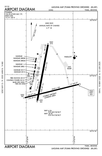
(KLGF) Laguna Army Airfield (Yuma Proving Ground)
No ratings | No reviews
Yuma Proving Ground (Yuma), AZ
(928) 328-5028
Overview
Attendance:
Attended
Clsd Hol
FAA
Year-round,Mon-Fri/0600-1600
FAA
Elevation:
433 ft (Surveyed)
Tower:
Apch Ctl Svc Prvvd By Yuma Cerap On 124.7/371.975 (Yuma Rcag). Dep Ctl Svc Prrvd By Yuma Cerap On 125.55/282.325 (Yuma/A Rcag).
FAA
Tower Hrs: 0600-1600 MON-FRI, CLSD HOL, O/T BY NOTAM.
FAA
Airspace:
CLASS D SVC 0600-1600 MON-FRI, CLSD HOL; OTHER TIMES CLASS G.
FAA
Fees:
None
Timezone:
MST (UTC-07:00)
Sunrise-Sunset:
5:47 am - 7:42 pm
Evening-Morning Civil Twilight:
8:10 pm
(Today)
(Today)
-
5:21 am
(Tomorrow)
(Tomorrow)
Runway
Satellite
Sectional
FBOs and Other Businesses
Submit New FBO
AOPA Travel Discounts 
FlightBridge is the ultimate all-in-one travel booking platform built for the general aviation community. AOPA Members receive free access to FlightBridge with AOPA discounted rates automatically applied. Members save an average of 30% on hotel bookings! Learn more about FlightBridge HERE.
Local Food/Lodging/Activities
Local Attractions
Local Activities
Restaurants
Hotels and Lodging
Travel Discounts
Flying Clubs
Submit New Flying Club
Runway 18/36
Dimensions:
6,142 × 151 ft
(1,872 × 46 m)
(1,872 × 46 m)
Weight Bearing Cap:
n/a
Surface:
asphalt, no surface treatment, condition not reported
Runway Edge Lights:
Medium
Comments:
n/a
| Designator: | 18 | 36 |
| Elevation: | 409.6 ft | 361 ft |
| Heading: | n/a | n/a |
| Gradient: | 0.79% down | 0.79% up |
| Traffic Pattern: | Left Pattern | Right Pattern |
| Markings: | none, in Poor condition | none, in Poor condition |
| Approach Lighting: |
|
|
| Displaced Threshold: | n/a | n/a |
| ILS/LOC: | n/a | n/a |
| Obstructions: | n/a | n/a |
| Comments: | n/a | n/a |
Runway 06/24
Dimensions:
6,043 × 100 ft
(1,842 × 30 m)
(1,842 × 30 m)
Weight Bearing Cap:
n/a
Surface:
asphalt, no surface treatment, condition not reported
Runway Edge Lights:
n/a
Comments:
n/a
| Designator: | 06 | 24 |
| Elevation: | 366.6 ft | 424.9 ft |
| Heading: | n/a | n/a |
| Gradient: | 0.96% up | 0.96% down |
| Traffic Pattern: | Right Pattern | Left Pattern |
| Markings: | basic, in Fair condition | basic, in Fair condition |
| Approach Lighting: | n/a | n/a |
| Displaced Threshold: | n/a | n/a |
| ILS/LOC: | n/a | n/a |
| Obstructions: | n/a | n/a |
| Comments: | n/a | n/a |
Helipad H1
Dimensions:
40 × 40 ft
(12 × 12 m)
(12 × 12 m)
Weight Bearing Cap:
n/a
Surface:
asphalt, no surface treatment, condition not reported
Runway Edge Lights:
n/a
Comments:
n/a
| Designator: | H1 |
| Elevation: | 365 ft |
| Markings: | n/a |
| Obstructions: | n/a |
| Comments: | n/a |
Helipad H2
Dimensions:
40 × 40 ft
(12 × 12 m)
(12 × 12 m)
Weight Bearing Cap:
n/a
Surface:
asphalt, no surface treatment, condition not reported
Runway Edge Lights:
n/a
Comments:
n/a
| Designator: | H2 |
| Elevation: | 360 ft |
| Markings: | n/a |
| Obstructions: | n/a |
| Comments: | n/a |
Helipad H3
Dimensions:
40 × 40 ft
(12 × 12 m)
(12 × 12 m)
Weight Bearing Cap:
n/a
Surface:
asphalt, no surface treatment, condition not reported
Runway Edge Lights:
n/a
Comments:
n/a
| Designator: | H3 |
| Elevation: | 362 ft |
| Markings: | n/a |
| Obstructions: | n/a |
| Comments: | n/a |
TFRs
Location: LGF
Please verify all content below using the FAA TFR Search Site or with a flight briefer.
TFR count: 0
NOTAMs
Location: LGF
Please verify all content below using the FAA NOTAM Search Site or with a flight briefer.
NOTAM count: 4
| Number: | Start Date: (UTC) | End Date: (UTC) | Condition: |
|---|---|---|---|
| 06/24/2025 2136 | 09/17/2025 0700 | INTS PARADROPS OPERATIONS VCNTY 5NM OF AFLD AT FL180 AND BELOW. | |
| 07/22/2025 1501 | 09/16/2025 1300 | AERODROME AERODROME RWY 18/36 PAPI PHOTO CELL INOP AND SET TO DAY BRIGHT UFN. | |
| 07/22/2025 1458 | 09/16/2025 2359 | TWY FOXTROT OPEN TO ONLY HIGH WING ACFT. NO AFCT SMALLER THAN A CASA 212 ALLOWED TO ENTER TWY FOXTROT FROM R… | |
| 07/22/2025 1456 | 09/16/2025 1300 | ALL VTOL AIRCRAFT ARE RESTRICTED TO ROLL ON ARRIVAL/DEPARTURE ONLY. | |
Additional Remarks
Ctn: C-130 & Lrgr Turn Around on Rwy Na Exc Prior Apvl for Emerg or Congestion.
Source:
FAA
Federal Aviation Administration
Ctn: Operations on Cibola Range 1 Nm. Paja In vicinity of 5 Nm.
Source:
FAA
Federal Aviation Administration
Ctn: Uas Operations Fm Laguna Army Airfield When Rstd Asp Actv; CTC Laguna Air Traffic Control Tower Prior to Entry.
Source:
FAA
Federal Aviation Administration
Ctn: Wildlife & Coyotes on & In vicinity of Arpt; Spcly At Ngt.
Source:
FAA
Federal Aviation Administration
For Clearance Delivery Contact Yuma CERAP Cd At 982-269-9569.
Source:
FAA
Federal Aviation Administration
Fuel: 100LL, F24 Avbl 1340-2400Z Mon-Fri; Clsd Hol. Pol Avbl with 24 Hr Prior Permission Required for Tsnt. Contr Fuel - Avcard Only.
Source:
FAA
Federal Aviation Administration
Jasu-5(Gpu) 3(59B2-1B).
Source:
FAA
Federal Aviation Administration
Misc: Late Arr - Base Operations D899-2014/2241, 928-328-2014/2241.
Source:
FAA
Federal Aviation Administration
Operations 0600-1600 Mon-Fri; Clsd Hol; Other Time by Notam.
Source:
FAA
Federal Aviation Administration
Rstd: Clsd Field Operations Prior Permission Required - Base Operations or Laguna Ops.
Source:
FAA
Federal Aviation Administration
Rstd: Offl Bus Only. Rstd Area 4 Nm E. Ovft of Housing Area 3 Nm Southwest Na. Tsnt 24 Hr Prior Permission Required - D899-2014/2241, C928-328-2014/2241.
Source:
FAA
Federal Aviation Administration
Svc: Fuel, Lox Svc Avbl - Base Ops.
Source:
FAA
Federal Aviation Administration
Tran Alert: Ltd Maint Svc Avbl.
Source:
FAA
Federal Aviation Administration
RESTRICTED. MILITARY AIRPORT. PRIOR PERMISSION REQUIRED. CONTACT BASE OPS MANAGER 928/328-2241, 928/328-2014
Source:
AM
Airport Manager
Noise Abatement
Instrument Procedures
Data Cycle:
Operations & More Information
Lat/Long:
- 32.86458, -114.39298
- 32° 51′ 52.5″ N, 114° 23′ 34.7″ W
- 32° 51.875′ N, 114° 23.579′ W
ARTCC:
Los Angeles (ZLA)
App/Depart Control Facility:
Unknown
Chart:
NACO: Phoenix Sectional
FSS:
Prescott (PRC)
1-800-WX-BRIEF
1-800-WX-BRIEF
Wind Indicator:
Yes
Mag Var:
13E (1980)
NOTAM Facility:
Seg Circle:
No
Beacon:
Present
Lighting:
Actvt MIRL Rwy 18/36 - 126.2. PAPI Rwy 18 & 36 Opr Consly Durg Ops; Other Time on Req - Base Ops.
FAA
Pattern Altitude:
Tfc Pat: Rgt Tfc Rwy 06 and 36. F/W 1700 Ft MSL. R/W 1100 Ft MSL. No Rgt Tfc Rwy 18.
FAA
Special Operations:
Helicopter Ops
FAA
Communications Card
| Type: | Frequency / Phone: | Sector / Comments: | Call Sign: |
|---|---|---|---|
| ATIS | 128.225 | Laguna | |
| AWOS-3PT | Laguna | ||
| Clearance Delivery Phone | (982) 269-9569 | Yuma CERAP Cd | |
| CTAF | 126.2 | Laguna | |
| Ground Control | 121.8 | Laguna | |
| RANGE CTL | 119.0 | Laguna | |
| Tower | 126.2 | Laguna |
Navaids
Services
Fuel:
100LL Low-Lead
AM
Engine Repair:
None
Airframe Repair:
None
Bottled Oxygen:
None
Bulk Oxygen:
None
Customs:
None
Transportation:
None Reported
AM
Activities:
None Reported
Camping On Field:
None Reported
Aircraft & Activity
Webcams
METARs
TAFs
Contact Addresses
Owner
US Army Aeronautical Services Agency