FAA Information Effective: May 15, 2025
All information is provided from the FAA unless otherwise noted.
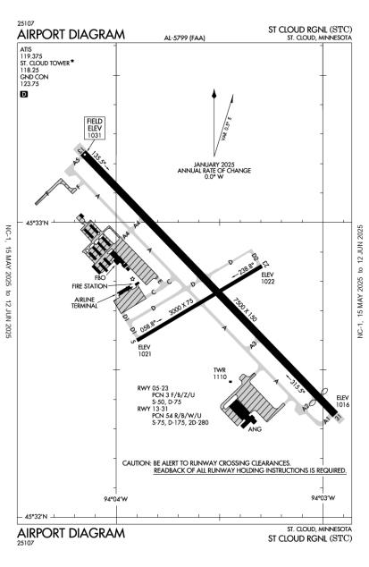
(KSTC) St Cloud Regional Airport
No ratings | No reviews
St Cloud, MN
(320) 255-7292
Overview
Attendance:
Attended
Year-round, 7 Days a Week,0500-2330
FAA
Elevation:
1,031 ft (Estimated)
Tower:
Apch/Dep Svc Prvdd By Minneapolis Artcc On Freqs 121.05/235.775 (Princeton Rcag).
FAA
Communications Prvdd By Princeton Radio On Freq 122.5 (St Cloud Rco).
FAA
Tower Hrs: 0700-2300
FAA
Airspace:
CLASS D SVC 0700-2300; OTHER TIMES CLASS E
FAA
Fees:
Timezone:
CDT (UTC-05:00)
Sunrise-Sunset:
5:32 am - 8:59 pm
Evening-Morning Civil Twilight:
9:35 pm
(Today)
(Today)
-
4:54 am
(Tomorrow)
(Tomorrow)
Minimum Fuel Prices:
$6.29
100LL (full)
$6.29
Jet-A-Premix/Prist (full)
Runway
Satellite
Sectional
FBOs
Submit New FBO
STC Aviation, Inc
No ratings | Be the first to review this business
Services Offered:
Maintenance
Car Rental
Sales
$6.29 | 100LL | full
$6.29 | Jet-A-Premix/Prist | full
Location:
On field: CTR
Phone:
(320) 253-1500
Freq. Monitored:
Fees:
Landing, Other
Flight Training
Submit New Flight School
Other businesses
Submit New Business
AOPA Travel Discounts 
FlightBridge is the ultimate all-in-one travel booking platform built for the general aviation community. AOPA Members receive free access to FlightBridge with AOPA discounted rates automatically applied. Members save an average of 30% on hotel bookings! Learn more about FlightBridge HERE.
Local Food/Lodging/Activities
Local Attractions
Local Activities
Restaurants
Hotels and Lodging
Travel Discounts
302 Airport Dr, Coldwater, MI 49036
(320) 252-5058
STC
Prop Blast Café (Mon-Fri-7:30am-2pm)
Flying Clubs
Submit New Flying Club
Runway 13/31
Dimensions:
7,500 × 150 ft
(2,286 × 46 m)
(2,286 × 46 m)
Weight Bearing Cap:
Single wheel: 75,000 lbs
Double wheel: 175,000 lbs
Double tandem: 280,000 lbs
Double wheel: 175,000 lbs
Double tandem: 280,000 lbs
Surface:
concrete, grooved, in good condition
Runway Edge Lights:
High
Comments:
Rwy 13/31 200 Ft Blast Pad Each End.
FAA
| Designator: | 13 | 31 |
| Elevation: | 1,030.5 ft | 1,015.9 ft |
| Heading: | 133° magnetic 136° true | 313° magnetic 316° true |
| Gradient: | 0.19% down | 0.19% up |
| Traffic Pattern: | Left Pattern | Left Pattern |
| Markings: | precision, in Fair condition | precision, in Fair condition |
| Approach Lighting: |
|
|
| Displaced Threshold: | n/a | 500 ft |
| ILS/LOC: | ILS | ILS |
| Obstructions: | n/a | Trees, 255 ft Right ft of center, 24 ft high, 996 ft from end, 33:1 clearance slope |
| Comments: | n/a | n/a |
Runway 05/23
Dimensions:
3,000 × 75 ft
(914 × 23 m)
(914 × 23 m)
Weight Bearing Cap:
Single wheel: 50,000 lbs
Double wheel: 75,000 lbs
Double wheel: 75,000 lbs
Surface:
asphalt, no surface treatment, in good condition
Runway Edge Lights:
Medium
Comments:
Rwy 05/23 not Avbl for Skedd Acr Operations with More Than 9 Psgr Seats or Unsked Acr At Least 31 Psgr Seats.
FAA
| Designator: | 05 | 23 |
| Elevation: | 1,021.1 ft | 1,022 ft |
| Heading: | 056° magnetic 059° true | 236° magnetic 239° true |
| Gradient: | 0.03% up | 0.03% down |
| Traffic Pattern: | Left Pattern | Left Pattern |
| Markings: | basic, in Good condition | basic, in Good condition |
| Approach Lighting: |
|
|
| Displaced Threshold: | n/a | n/a |
| ILS/LOC: | n/a | n/a |
| Obstructions: | n/a | Trees, 412 ft Right ft of center, 69 ft high, 2,050 ft from end, 26:1 clearance slope |
| Comments: | n/a | n/a |
TFRs
Location: STC
Please verify all content below using the FAA TFR Search Site or with a flight briefer.
TFR count: 0
NOTAMs
Location: STC
Please verify all content below using the FAA NOTAM Search Site or with a flight briefer.
NOTAM count: 3
| Number: | Start Date: (UTC) | End Date: (UTC) | Condition: |
|---|---|---|---|
| 04/114 | 04/26/2025 1418 | 06/10/2025 1417 | OBST TOWER LGT (ASR 1023850) 453336.00N0940821.00W (3.5NM WNW STC) 1507.9FT (481.0FT AGL) U/S |
| 5/7309 | 06/02/2025 1300 | 06/09/2025 2331 | IAP ST CLOUD RGNL, ST CLOUD, MN.
ILS OR LOC RWY 31, AMDT 4A...
RADAR REQUIRED FOR PROCEDURE ENTRY EXCEPT FOR… |
| 11/004 | 11/06/2024 1400 | 11/05/2025 2359 | AIRSPACE UAS WI AN AREA DEFINED AS 452236N0935728W
(4.1NM S 8Y6) TO 452420N0940207W (3.6NM SW 8Y6) TO 45260… |
Additional Remarks
Crop Dusting Operations on and in Vicinity of Airport During Summer Months.
Source:
FAA
Federal Aviation Administration
Deer, Migratory Waterfowl, and Other Wildlife on & In vicinity of Arpt.
Source:
FAA
Federal Aviation Administration
Flight Training on & In vicinity of Arpt.
Source:
FAA
Federal Aviation Administration
For Cd When Air Traffic Control Tower is Clsd CTC FSS Via Rco, If Una CTC Minneapolis ARTCC at 651-463-5588.
Source:
FAA
Federal Aviation Administration
Helipad not Visible from Air Traffic Control Tower and Approach Surfaces.
Source:
FAA
Federal Aviation Administration
Line of Sight Visibility is Restricted from the 13 & 23 Approach and Runway 13 & 5 Approach
Source:
FAA
Federal Aviation Administration
Ry 31 Calm Wind Ry.
Source:
FAA
Federal Aviation Administration
24 Hrs Prior Permission Required for Unsked Acr Operations with More Than 30 Psgr Seats Call Airport Manager 320-255-7292.
Source:
FAA
Federal Aviation Administration
Security Directive SD-8G
Source:
AM
Airport Manager
Noise Abatement
Instrument Procedures
Operations & More Information
Lat/Long:
- 45.54622, -94.05939
- 45° 32′ 46.4″ N, 94° 3′ 33.8″ W
- 45° 32.773′ N, 94° 3.563′ W
ARTCC:
Minneapolis (ZMP)
App/Depart Control Facility:
Unknown
Chart:
NACO: Twin Cities Sectional
FSS:
Princeton (PNM)
1-800-WX-BRIEF
1-800-WX-BRIEF
Wind Indicator:
Lighted
Mag Var:
03E (1995)
NOTAM Facility:
Seg Circle:
Yes
Beacon:
Present
Lighting:
Pilot Activated Lighting:
- low intensity: 3 clicks in 5 secs
- medium intensity: 5 clicks in 5 secs
- high intensity: 7 clicks in 5 secs
AM
Actvt MALSR Rwy 13 & 31 - CTAF. PAPI 13 & 31; HIRL Rwy 13/31; MIRL Rwy 05/23 Preset on Low Intst, to Incr Intst & Actvt - CTAF.
FAA
Pattern Altitude:
Light Aircraft 2031 MSL
AM
Special Operations:
Communications Card
| Type: | Frequency / Phone: | Sector / Comments: | Call Sign: |
|---|---|---|---|
| ASOS | 125.075T (320) 240-8781 | St Cloud | |
| ATIS | 119.375 | St Cloud | |
| CTAF | 118.25 | St Cloud | |
| Ground Control | 123.75 | St Cloud | |
| Tower | 118.25 | St Cloud |
Navaids
Services
Fuel:
100LL Low-Lead, Jet A
AM
Engine Repair:
Major
AM
Airframe Repair:
Major
AM
Bottled Oxygen:
None
Bulk Oxygen:
High
AM
Customs:
None
Transportation:
Courtesy Transportation, Public Transportation
AM
Activities:
Intensive Flight Training, On field restaurant/café
AM
Camping On Field:
None Reported
Aircraft & Activity
Webcams
METARs
TAFs
Contact Addresses
Airport Manager
Bill P Towle
Saint Cloud, MN 56304-9634
(320) 255-7292 (Office)
Owner
St Cloud Regional Airport Authority
Saint Cloud, MN 56304-9634
(320) 255-7292 (Office)
Remarks: