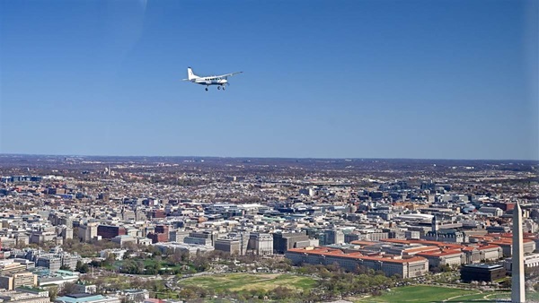
FAA Information Effective: 5/2/2013
AOPA members save at 3,000+ GA airports.Book Now!
KRBECivil
Public Use
Public Use
Rock County
Bassett, NE
Phone: 402-684-2254
Nearby airports
Operations | Communications | Weather |
Runways |
Comments |
Remarks |
Procedures | Services, Businesses & FBOsKneeboard Format
Overview
| Attendance: |
Not Attended Unattended |
| Tower: | No |
| Elevation: | 2,349 ft (716.0 m) (Surveyed) |
| Location: | 2.00 mi. SW of Bassett |
| Beacon: | Present (white-green) |
| Approaches: | RNAV, GPS, NDB |
| Runways: | 02/20
(unpaved)
, 13/31
Longest paved runway: 4699 ft |
| Fees: | Hangar |
Expand Additional Remarks
Runway 02/20
| Dimensions: | 2202 x 120ft. / 671.2 x 36.6m | Weight Bearing Cap: | |
| Surface: | turf, grass, sod, no surface treatment, in fair condition | Runway Edge Lights: |
| # | Elev/Hdg | Tr. Pat. | Markings | Approach Lights | TD Point | ILS/LOC | Obstructions | Comments/Noise | ||
|---|---|---|---|---|---|---|---|---|---|---|
| 02 | 2343.9ft. MSL 27° mag 35° true 0.1% down | No Data | Pole, 180 ft Right of center, 24 ft high, 440 ft from end, 18:1 clearance slope | Pole is An Obstn during Irrigation Season Only | ||||||
| 20 | 2341.9ft. MSL 207° mag 215° true 0.1% up | No Data | Road, 157 ft Right of center, 15 ft high, 320 ft from end, 21:1 clearance slope | |||||||
Runway 13/31
| Dimensions: | 4699 x 75ft. / 1432.3 x 22.9m | Weight Bearing Cap: | Single wheel: 4000 lb |
| Surface: | concrete, no surface treatment, in good condition | Runway Edge Lights: | medium |
| # | Elev/Hdg | Tr. Pat. | Markings | Approach Lights | TD Point | ILS/LOC | Obstructions | Comments/Noise | ||
|---|---|---|---|---|---|---|---|---|---|---|
| 13 | 2344.3ft. MSL 133° mag 141° true 0.1% up | non-precision | visual glide slope: 2-Light/Left-Side PAPI | Road, 185 ft Left of center, 18 ft high, 565 ft from end, 20:1 clearance slope | ||||||
| 31 | 2349.3ft. MSL 313° mag 321° true 0.1% down | non-precision | visual glide slope: 2-Light/Left-Side PAPI | |||||||
Business/Service Information
| Name | Location | Freq. Monitored | Main Phone | |
|---|---|---|---|---|
| Rock County Airport |
| BASSETT, NE | 402-684-2254 |
Services at this airport:
Fuel: 100LL Low-LeadExpand Nearby restaurants, attractions
Operations & More Information
| Lat/Long: | N42 34.2683' / W99 34.1717' |
| Charts: | NACO:
Omaha Sectional |
| Mag Var: | 08E (1990) |
| ARTCC: | Denver (ZDV) |
| FSS: | Columbus (OLU) 1-800-WXBRIEF |
| NOTAM Facility: | OLU |
| Approach/Departure Control Facility | |
| Pattern Altitude: | Fixed Wing: 3149 MSL |
| Wind Indicator: | Lighted |
| Seg. Circle: | Yes |
| Lighting: | Pilot Activated Lighting:
|
Aircraft & Activity
Based GA Aircraft
| Single Engine: | 5 |
| Multi Engine: | 0 |
| Jets: | 0 |
| Helicopters: | 0 |
| Gliders: | |
| Ultralights: |
Airport Activity
| GA Local: | 1,200 |
| GA Itinerant: | 800 |
| Commercial: | |
| Air Taxi: | |
| Military: |
(12-month period ending on 6/27/2011)
Air Safety Institute Resources
Expand Communications Card
Contact Addresses
| Owner: | Airport Manager: |
| Rock County Airport Authority | Bernie Hart |
| Jim Nelson, Chairman, Po Box 385 | 504 S. State Street |
| Bassett, NE 68714-0385 | Bassett, NE 68714-5046 |
| 402-684-3436 (Office) | 402-684-2254 (Office) |
| Airport Manager Admin |