FAA Information Effective: Jul 10, 2025
All information is provided from the FAA unless otherwise noted.
(KDBN) W H 'Bud' Barron Airport
No ratings | No reviews
Dublin, GA
(478) 272-4755
Overview
Attendance:
Attended
Year-round,Mon-Fri/0800-1700
FAA
Elevation:
311 ft (Surveyed)
Tower:
No
Airspace:
Unknown
Fees:
None
Timezone:
EDT (UTC-04:00)
Sunrise-Sunset:
6:41 am - 8:37 pm
Evening-Morning Civil Twilight:
9:05 pm
(Today)
(Today)
-
6:14 am
(Tomorrow)
(Tomorrow)
Runway
Satellite
Sectional
FBOs and Other Businesses
Submit New FBO
AOPA Travel Discounts 
FlightBridge is the ultimate all-in-one travel booking platform built for the general aviation community. AOPA Members receive free access to FlightBridge with AOPA discounted rates automatically applied. Members save an average of 30% on hotel bookings! Learn more about FlightBridge HERE.
Local Food/Lodging/Activities
Local Attractions
Local Activities
Restaurants
Hotels and Lodging
Travel Discounts
Golden Corral
(478) 275-2384
Red Lobster
(478) 275-9510
Dublin Cab
(478) 272-9643
Yellow Cab
(478) 272-3171
DBN
Golden Corral
Red Lobster
Dublin Cab
Yellow Cab
Flying Clubs
Submit New Flying Club
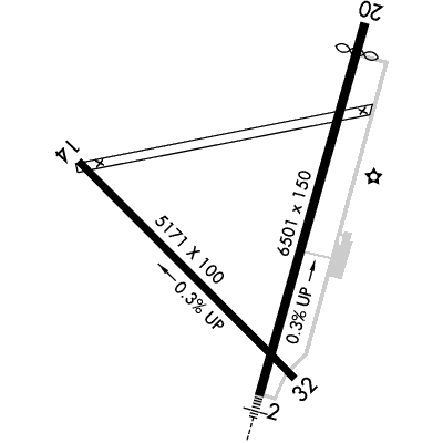
Runway 02/20
Dimensions:
6,501 × 150 ft
(1,982 × 46 m)
(1,982 × 46 m)
Weight Bearing Cap:
Single wheel: 30,000 lbs
Double wheel: 53,000 lbs
Double wheel: 53,000 lbs
Surface:
asphalt, no surface treatment, in good condition
Runway Edge Lights:
High
Comments:
n/a
| Designator: | 02 | 20 |
| Elevation: | 290.9 ft | 311 ft |
| Heading: | 020° magnetic 016° true | 200° magnetic 196° true |
| Gradient: | 0.31% up | 0.31% down |
| Traffic Pattern: | Left Pattern | Left Pattern |
| Markings: | precision, in Good condition | precision, in Good condition |
| Approach Lighting: |
|
|
| Displaced Threshold: | n/a | 489 ft |
| ILS/LOC: | ILS/DME | n/a |
| Obstructions: | Trees, 602 ft Right ft of center, 64 ft high, 1,419 ft from end, 19:1 clearance slope | Road, 36 ft Left ft of center, 15 ft high, 201 ft from end |
| Comments: | n/a | Controlling Obstruction Exceeds A 45 Degree Slope FAA |
Runway 14/32
Dimensions:
5,171 × 100 ft
(1,576 × 30 m)
(1,576 × 30 m)
Weight Bearing Cap:
Single wheel: 28,000 lbs
Double wheel: 44,000 lbs
Double wheel: 44,000 lbs
Surface:
asphalt, no surface treatment, in fair condition
Runway Edge Lights:
n/a
Comments:
n/a
| Designator: | 14 | 32 |
| Elevation: | 304.2 ft | 290.8 ft |
| Heading: | 140° magnetic 136° true | 320° magnetic 316° true |
| Gradient: | 0.26% down | 0.26% up |
| Traffic Pattern: | Left Pattern | Left Pattern |
| Markings: | basic, in Good condition | basic, in Good condition |
| Approach Lighting: | n/a | n/a |
| Displaced Threshold: | n/a | n/a |
| ILS/LOC: | n/a | n/a |
| Obstructions: | Trees, Both-Sides, 64 ft high, 1,445 ft from end, 19:1 clearance slope | Trees, Both-Sides, 98 ft high, 1,604 ft from end, 14:1 clearance slope |
| Comments: | n/a | n/a |
TFRs
Location: DBN
Please verify all content below using the FAA TFR Search Site or with a flight briefer.
TFR count: 0
NOTAMs
Location: DBN
Please verify all content below using the FAA NOTAM Search Site or with a flight briefer.
NOTAM count: 22 (Partial list shown. Expand to see full list HERE.)
| Number: | Start Date: (UTC) | End Date: (UTC) | Condition: |
|---|---|---|---|
| 07/671 | 07/23/2025 1600 | 07/23/2025 1900 | RWY 14/32 WIP MEN AND EQPT |
| 05/737 | 05/23/2025 0156 | 08/20/2025 2359 | OBST TOWER LGT (ASR 1230397) 323126.20N0825520.20W (4.0NM SE DBN) 620.4FT (380.2FT AGL) U/S |
| 3/8938 | 09/12/2023 1418 | 09/12/2025 1417 | ODP W H 'BUD' BARRON, DUBLIN, GA.
TAKEOFF MINIMUMS AND (OBSTACLE) DEPARTURE PROCEDURES AMDT 1...
TAKEOFF MI… |
| 07/573 | 07/21/2025 1508 | 09/04/2025 2359 | OBST TOWER LGT (ASR 1319160) 322655.37N0830226.18W (7.49NM SSW DBN) 568FT (320FT AGL) U/S |
| 07/670 | 07/23/2025 1600 | 07/23/2025 1900 | RWY 02/20 CLSD |
| 06/609 | 06/15/2025 1025 | 07/30/2025 1025 | OBST TOWER LGT (ASN 2021-ASO-1634-OE) 322344N0825034W (12.3NM SE DBN) 504FT (265FT AGL) U/S |
| 06/958 | 06/26/2025 0248 | 08/10/2025 0400 | OBST TOWER LGT (ASR 1307601) 322718.80N0830053.70W (6.72NM SSW DBN) 503FT (260FT AGL) U/S |
| 06/138 | 06/05/2025 1119 | 09/03/2025 2359 | OBST TOWER LGT (ASR 1236315) 323329.80N0825401.90W (4.3NM E DBN) 509.8FT (298.9FT AGL) U/S |
Additional Remarks
For Apch/Dep Svc CTC Atlanta Approach at 678-364-6131. When Atlanta Approach Unavbl CTC Atlanta ARTCC at 770-210-7692.
Source:
FAA
Federal Aviation Administration
For Cd If Una to CTC on FSS Freq, CTC Atlanta Approach at 678-364-6132, When Air Traffic Control Tower Clsd CTC Atlanta ARTCC at 770-210-7692.
Source:
FAA
Federal Aviation Administration
Noise Abatement
Instrument Procedures
Data Cycle:
Operations & More Information
Lat/Long:
- 32.56472, -82.98497
- 32° 33′ 53.0″ N, 82° 59′ 5.9″ W
- 32° 33.883′ N, 82° 59.098′ W
ARTCC:
Atlanta (ZTL)
App/Depart Control Facility:
A80
Chart:
NACO: Atlanta Sectional
FSS:
Macon (MCN)
1-800-WX-BRIEF
1-800-WX-BRIEF
Wind Indicator:
Yes
Mag Var:
04W (2000)
NOTAM Facility:
Seg Circle:
Yes
Beacon:
Present
Lighting:
Pilot Activated Lighting:
- low intensity: 3 clicks in 5 secs
- medium intensity: 5 clicks in 5 secs
- high intensity: 7 clicks in 5 secs
AM
Actvt MALSR Ry 02 - CTAF. HIRL Ry 02/20 Oper Cont Dusk-2200; After 2200 Actvt - CTAF.
FAA
Pattern Altitude:
Light Aircraft 1110 MSL
Heavy Aircraft 1310 MSL
AM
Special Operations:
Communications Card
| Type: | Frequency / Phone: | Sector / Comments: | Call Sign: |
|---|---|---|---|
| Approach/Departure | 124.2 | Atlanta | |
| AWOS-3 | 118.425T (478) 277-9051 | ||
| CTAF | 122.7 | ||
| UNICOM | 122.7 |
Navaids
Services
Fuel:
100LL Low-Lead
AM
Engine Repair:
Major
AM
Airframe Repair:
Major
AM
Bottled Oxygen:
None
Bulk Oxygen:
None
Customs:
None
Transportation:
Courtesy Transportation
AM
Activities:
Intensive Flight Training
AM
Camping On Field:
None Reported
Aircraft & Activity
Webcams
METARs
TAFs
Contact Addresses
Airport Manager
Bryan Rogers, County Administrator
Dublin, GA 31040
(478) 272-4755 (Office)
Owner
Laurens County
Dublin, GA 31040
(478) 272-4755 (Office)