Avionics: Portables
Don’t leave home without it—Portables are indispensable weather tools
In-cockpit weather has made the leap from being regarded as a luxury to a near-necessity for pilots flying cross-country trips. From vintage and light sport airplanes to corporate jets, it’s increasingly common for aircraft—or the pilots flying them—to carry satellite receivers and GPS displays that provide a big-picture view of the changing weather around them. And given a choice of displaying datalink weather on panel-mount systems or portables, buyers are showing a strong preference for portables.
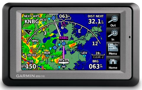
“The cheapest, easiest, and best way to get cockpit weather is with a portable,” said Stein Bruch, president and CEO of SteinAir, an avionics firm in Minnesota. “You can get a great portable GPS with a fantastic weather display for half of what it costs to add a weather receiver to a panel-mount GPS. And the subscription price [for satellite weather information] is exactly the same.”Adding an FAA-certified weather receiver to panel-mount systems such as a Garmin GNS 430/530 or Avidyne Entegra typically costs about $4,000. Portables capable of displaying datalink weather (such as Garmin’s 696 or aera, Bendix/King’s AV8OR, Anywhere Map, AvMap, and Flight Cheetah) are much less expensive to purchase—and they’re versatile GPS units that owners can remove from their airplanes and use on the ground at their destinations.
Among the portables, retail avionics firms say Garmin dominates the aviation market, and the company’s hockey-puck weather receivers give them a big advantage over rivals.
Garmin’s -96 series and aera, for example, use an interchangeable satellite weather receiver. An XM satellite weather subscription for one receiver can be used to show weather on virtually any Garmin portable, and the weather station doesn’t need a separate power supply. Most other portable GPS units have larger, more cumbersome satellite receivers that also require additional cables to power them.
“When pilots see all those cables, they figure that’s too many,” said Todd Hill, sales manager at Gulf Coast Avionics in Lakeland, Florida. “They want something simple and uncluttered.”
Hill said about 75 percent of the portable GPS units Gulf Coast sells have satellite weather capability, although it’s unclear how many buyers sign up for weather subscriptions.
There are no hard numbers on how many GA airplanes carry satellite weather, but air traffic controllers say they estimate the percentage is approaching half.
Among aircraft with integrated avionics suites such as the G1000, Avidyne Entegra, and Aspen Evolution weather receivers are built in, and it’s extremely unusual for owners of the high-end systems not to get satellite weather subscriptions.
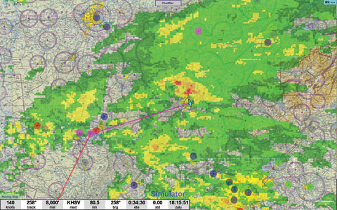
XM is the market leader for aviation satellite weather subscriptions covering the domestic United States, and they range in price from $35 to $100 a month; some require a $75 “activation fee.” (WSI InFlight provides domestic and international coverage through the Sirius and Iridium networks.) Datalink weather information is equally timely and accurate regardless of the device that pilots use to view it.
Without more competition, avionics firms say it is unlikely aviation weather subscription prices will drop. And aviation is such a small marketplace relative to satellite radio entertainment, boating, and other niches that pilots as a group have little bargaining leverage—even as the percentage of pilots using satellite weather grows.
The possibility of free in-cockpit weather has been a major selling point for the FAA’s future ADS-B system known as NextGen, and a few electronic flight bag developers such as Essential Flight Technology have begun offering free in-cockpit weather on its tablet computers through ADS-B as part of their subscription chart services. The ADS-B system is years away from full implementation, however, and aircraft owners must buy and install as-yet-undefined ADS-B “in” equipment to get other NextGen features such as traffic and terrain warnings.
Some pilots hope the iPad or other tablet computers may provide another way to gain access to low-cost in-cockpit weather. But avionics experts say it’s doubtful such devices will be able to provide anything like the accuracy and reliability of products designed and built specifically for aviation use.
“I love my iPad and use it all the time for flight planning and charts,” said Bruch of SteinAir. “But the iPad isn’t a replacement for real, in-flight weather on an aviation GPS or MFD.”
 Datalink subscriptions can be valuable for VFR pilots who limit their flying to good weather, because they graphically depict temporary flight restrictions. And TFRs can spring up without much advance warning, especially when the president or vice president is on the move.
There’s no conclusive proof that shows access to real-time weather information improves the safety of GA flying, but anecdotal information and common sense suggests that warning pilots well in advance of dangerous weather patterns and allowing them to make alternative plans well before they encounter it is beneficial. Aviation safety experts also caution that satellite weather should be used strategically and not tactically: It’s no substitute for airborne weather radar in picking through close-in adverse conditions.
Pilots routinely credit XM weather for helping them avoid hazardous conditions and complete trips they otherwise wouldn’t have been able to make. It also gives them a tool for making informed decisions on matters as varied as the best routes, departure times, and even whether to rent hangar space on overnight trips.
Bruch said pilot use of satellite weather is sure to expand in the future, whether the datalink information source is a subscription service or the ADS-B system. “Once pilots have had access to in-cockpit weather, they never want to fly more than 50 miles from home without it,” he said. “It greatly enhances safety and peace of mind. It's one of those products that, like GPS, you wonder how the world ever got by without it.”
E-mail the author at [email protected].
Related Articles


