Feature Spotlight: Weather Along Route
A crystal ball for weather forecasting?
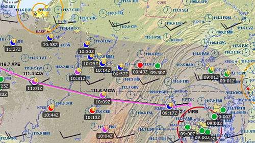
Well, sort of but without the dark room, tea leaves and tarot cards. The new Weather Along Route tool in the AOPA Flight Planner allows pilots to “look into the future” to see what the expected weather will be at each TAF station along their route when they are passing by. This works by calculating where the aircraft will be at each point of the route and then aligning that to the TAF that will be valid at that time. This month’s Feature Spotlight takes a closer look at this new and unique tool.

One of the challenges of planning a long cross-country flight is certainly finding an optimal weather window. The longer the flight, the more challenging this becomes. At Sun ‘n Fun this year, we observed pilots reviewing long lists of TAF reports and trying to calculate what was in store for them on their return flights. This requires a lot of mental gymnastics to calculate what time they would be in a specific area and then converting time zones and local time to figure out which TAF would be relevant. It occurred to us that a computer could do this calculation a lot faster (and more accurately) than a human. So out of that, the Weather Along Route tool was born. We released this new tool right before AirVenture this year and, to say the least, it was a big hit with pilots planning their trips back home.
Similar to some other planning tools in the AOPA Flight Planner, Weather Along Route shows a shaded corridor over the active route line. Within this corridor, color-coded icons are displayed for each TAF reporting station. At first glance, this may look similar to weather condition icons you may be familiar with in other tools and EFB apps. However, it’s important to know that unlike the other tools that show current weather conditions, the Weather Along Route tool shows forecast weather conditions based on the calculated station passing time for your flight. This takes all the guess work out of the planning by letting you see the actual TAF conditions that are predicted when you will be passing by each station. If you don’t like what you see, you can easily adjust the departure time slider backwards or forwards to see how departing earlier or later will impact the forecast weather. The condition icons will instantly update letting you see the results of an earlier or later departure.
Each reporting station can be investigated further by clicking on the condition icon. This will display the TAF details with a timeline that lists the all the TAF reports for that station in an easy to consume chronological order. Another unique feature is the Weather Hazard Advisor. This places a warning badge on the condition icons if any adverse weather is noted in the TAF. This is very important as it is quite possible to have VFR conditions with thunderstorms in the terminal area or vicinity. It’s not good enough to simply look at a green VFR icon and assume all is well, especially in the summer months when convective activity is prevalent. The warning badges call attention to potential hazardous conditions. This is truly a unique way to look at TAF reports and makes selecting an optimal departure time, or making the “Go/No-Go” decision a little easier.
A detailed video overview and tutorial of the Weather Along Route tool can be viewed on the AOPA Flight Planning Products YouTube channel here.
Give it a try yourself by going to: www.aopa.org/flightplanner.


