AOPA GO Gets Color-Coded Adverse Weather Conditions
 Adverse Weather Color-Coding
As pilots, we have a lot of options when it comes to weather data. From the weather person on our local television station to ADS-B technology in our cockpits and everything in-between, we are surrounded by weather information. Some of these different sources occasionally agree too! So how can we possibly make consuming weather information easier? Color-coding.
We’re used to interpreting colors while we fly. Many of the gauges and instruments in our cockpits use some sort of color-coding to represent different things. A quick glance at something shaded in red usually means something bad. Colors make it easier for our brains to quickly comprehend a status or condition rather than trying to interpret a bunch of numbers on a dial.
Ever heard the phrase “hiding in plain sight”? It’s certainly easy to overlook an important piece of information in a weather report, especially when reviewing a long list METARs or TAFs. With the new adverse condition color-coding introduced in this version of AOPA GO, we tried to make potentially dangerous conditions a little easier to extract from METAR or TAF reports. This is different than just color-coding a weather report as VFR, MVFR, IFR or LIFR. We still provide that information in AOPA GO, but we have gone a step further. Just seeing a green VFR symbol doesn’t mean everything is okey-dokey. We can easily, and even frequently, have VFR conditions but also have thunderstorms in the terminal area or vicinity. Remember, VFR, MVFR, IFR and LIFR are only based on visibility and ceiling. There’s a lot more to consider. So green doesn’t always mean go.
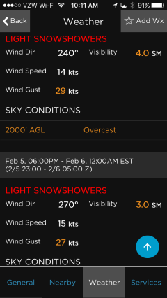
In AOPA GO v 1.4, certain conditions in METARs and TAFs are now color-coded based on severity. We use two different colors: orange and red. Conditions that warrant caution are colored orange while more severe conditions are shown in red. This makes these conditions “pop” out while scrolling through a long list of weather reports. For example, if a METAR includes moderate precipitation, mist, visibility 1 to 5 miles or a ceiling 1,000’ to 2,000’, the condition will be colored in orange. While thunderstorms, frozen precipitation, fog, visibility less than a mile or ceiling less than 1,000’ will be displayed in red text. There are other conditions including wind gusts or even high winds in general that get color-coded too. No matter our skill level or our personal minimums, knowing about these conditions is always helpful.
Favorite Airports and Favorite Weather Stations
Another new feature in this version of GO is the ability to save a dedicated list of favorite weather stations. GO has always had the ability to save a list of favorite airports, but sometimes the reason we add an airport to a favorite list is different based on how we want to use it. Some airports are in our list because we fly to it frequently but other times, we add it as a favorite because it is nearby and has good weather reporting. They’re both still favorites but our purpose for saving them is different. The list of favorite airports shows airport information (max runway length, elevation, traffic pattern altitude and common frequencies) in the quick details tile. While the list of favorite weather stations shows weather information (wind direction/velocity, visibility, ceiling, altimeter, temperature and dew point) in the quick details tiles. Since our purpose is different, the information displayed is different to match the purpose.
Another enhancement related to favorite airports is we now sync your list to the online version of the AOPA Airports Directory. This is a bi-directional sync so adding a favorite airport to GO or the online Airports Directory will add it to the other automatically.
Integration with FltPlan Go
The growing list of supported EFB apps now includes FltPlan Go in this version of AOPA GO. If you create a route in AOPA GO, or by using the AOPA Flight Planner on our website, you can now send those routes to FltPlan Go for use in the cockpit. Sending routes works the same way as the other EFB apps: Open the Flight Planning module of GO, select a route form the list, tap the NavLog button at the bottom to review the route and the click the Send to EFB button at the bottom. Select the EFB app you want to send the route to from the list (EFB app must be installed on the same device as AOPA GO). Your route will then be sent to the EFB app you selected automatically.
AOPA GO is a free member benefit and is available on iOS and Android smart phones and tablets.
Tutorial videos for these and all other features are available on the AOPA Flight Planning Products YouTube Channel.


