Wx Watch: Storm Survey
How thunderstorms are born
Web site of the month
Meteorologists look for an important marker for convective activity called CAPE—Convective Available Potential Energy. To be brief, CAPE is a combined measure of the heat, humidity, and instability of an air mass. To see CAPE depicted on weather charts, visit the Web site and click on “severe weather” on the links at the left of the page. Then click on the “CAPE” link under “severe wx indices.” Up pops a chart of CAPE values. CAPE values are expressed in Joules per kilogram, and run from 0 to 3,500-plus, with 0 being very stable air; 0 to 1,000 meaning marginally unstable air; 1,000 to 2,500 meaning moderately unstable air; 2,500 to 3,500 very unstable air; and 3,500-plus indicating extremely unstable air. The higher the CAPE number, the faster thunderstorms may build.— TAH
 All thunderstorms are not created equal. They vary from region to region, from season to season, and rely on slightly different mechanisms to help them fire off. Knowing these differences can help us better avoid convective activity. But first off, let’s set one ground rule for any and all thunderstorms: Avoid them using whatever tools you have at your disposal. Visual avoidance is the gold standard, because it’s the only way you can be assured of remaining clear of convective clouds.
What they all share
All thunderstorms rely on three basic elements: a lifting force, unstable air, and moisture. Without any one of these, classic convective activity cannot take place. Lifting forces can come from such sources as frontal clashes, thermally induced vertical motions, or upper-air dynamics that cause converging air masses at the surface.
Instability exists whenever rising air masses keep on rising because of cooler ambient air. Another way to say it is that the ambient air experiences greater-than-standard drops in temperature with altitude. As we all should know, the standard lapse rate is 2 degrees Celsius/3.5 degrees Fahrenheit per thousand feet. However, if the actual lapse rate is 4 degrees Celsius, then the atmosphere is that much more conducive to accelerating a rising parcel of heated air. Think of it this way: A heated parcel of air rises, but only when the surrounding air is cooler than the parcel. And a cooler-than-standard lapse rate is one way to foster an unstable condition. You can do a little of your own data collection to ascertain potential instability. Just record the outside air temperature as you climb. Write down the temperature values for each 1,000 feet you climb, and you can roughly determine the stability of the air. Glider tugs and sailplane pilots do this all the time, to determine if conditions are ripe for soaring in thermals.
Moisture is necessary because it releases latent heat as it rises and condenses into water droplets large and small. This heat helps propel heated parcels ever faster. When enough droplets condense, rain—and/or hail—falls. And friction between droplets sets up the electrical fields that can cause lightning. Without lightning there cannot be thunder, and without thunder there can’t be a thunderstorm!
Air mass thunderstorms
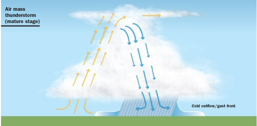 Air mass thunderstorms rely mainly on localized heating of the Earth’s surface. In the mature stage, there are both updrafts and downdrafts. Downdraft-induced outflow boundaries bring cold air to the surface and can kick off more storms.
 Everyone knows these sorts of storms. By late afternoon of a sunny, humid day, a puffy cumulus forms, morphs into a towering cumulus, then turns into a full-blown thunderstorm. All of this takes place in about an hour. The storm may exist all by its lonesome, or be part of an area with scattered (three-eighths’ to four-eighths’ coverage) storms.
Meteorologists call these pulse thunderstorms because they have short lifetimes and are not part of a larger system. It’s these pulse storms that have the three classic stages in thunderstorm development:
Cumulus stage. This is the formative step, and is characterized by a central core of rising, heated air (it could even originate from a mall parking lot!), the formation of the towering cumulus cloud, and net rising motions within the storm cell.
Mature stage. Now, both updrafts and downdrafts coexist as the towering cumulus transforms into a full-blown cumulonimbus cloud. Hail may form at the coldest cloud tops, and the first lightning strikes may occur.
Dissipating stage. Rainfall marks the beginning of the end of the air mass storm. With rainfall come downdrafts and microbursts—features that can occur in any type of convective storm, and which choke any inflows that might help sustain the storm’s circulation.
Air mass thunderstorms are easiest to visually avoid because they tend to be so far apart and short-lived. In Florida, air mass thunderstorms are daily occurrences in the warmer months of the year. But they’re easily dodged. Just fly before the heat of the day, wait them out, or fly around them.
When air mass thunderstorms form in clusters, another dynamic can kick in. Some storms can be in the early stages of their development, while others may be in the mature or dissipating stages. The result is a multicell thunderstorm situation. Multicell storms can last for hours, until all the cells have finished their life cycles. The reason they last so long is that outflow boundaries—downbursts of colder air that spread out from parent cells—can create even more storms as they lift unstable air ahead of them.
Embedded thunderstorms
As the name suggests, embedded thunderstorms exist within a much larger cloud mass. Cold, warm, and occluded fronts can create the moisture, lifting, and instability to create thunderstorms, but the danger here is that they cannot as easily be observed from the cockpit of an airplane flying in the lower levels of the atmosphere.
The problem typically emerges like this: A pilot on an IFR flight plan is flying in cloud, trying to negotiate a front. Thunderstorms crop up, but the pilot is unable to visually avoid them. He may have datalink, airborne weather radar, or lightning detection, but none of these can indicate truly safe escape routes. Yes, satellite-radar composite imagery is available from datalink weather providers, but remember that time delay in the image update cycle. The best plan of action here is to make a 180-degree turn—or risk stumbling into a thunderstorm that’s masked by clouds. Another tried-and-true avoidance strategy is to stay on the ground until the frontal activity has passed.
Elevated thunderstorms
We like to think of thunderstorms as propagating from the surface—like the air mass storms we just discussed. However, thunderstorms can form aloft. These elevated thunderstorms have their origins, and their bases, several thousand feet above the ground. They’re created along warm front surfaces as warm air rides up over the retreating cold air masses ahead of them. As the warm, moist air overruns the cold air below, it’s lifted and creates elevated convection. The same thing can happen behind a cold front, as warm air is lifted above the frontal slope. (This is a somewhat rare event, because most storms and/or precipitation typically occur ahead of a cold front).
When dealing with this sort of frontal setup, it may look tempting to fly beneath any cloud decks. But beware. The same downdrafts and microbursts that plague other types of thunderstorms can happen with elevated convection. That’s why the standard advice is never to fly beneath a storm—even if you can see through to sunny skies beyond.
Supercells
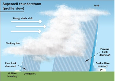 Supercell thunderstorms generate a self-sustaining cycle of updrafts and downdrafts. Strong wind shear aloft helps supercell storms produce large hail and tornadoes.
 Supercell thunderstorms are behemoths of five to 10 nm in diameter that prowl the central United States in the summer months. They’re unique in that they typically last up to four hours (though they can go on for 12 to 16 hours), produce large hailstones, spawn tornadoes, and thus account for most of the damage attributed to severe thunderstorms. (A severe thunderstorm, by the way, is one bearing any combination of surface wind gusts of 50 knots or more, hail diameters of three-quarter-inch or greater, or tornadoes.) Cloud tops of these monsters can bust through the tropopause, reaching 50,000 to 60,000 feet in the worst cases. They’re definitely thunderstorms to be avoided by any pilot flying any airplane.
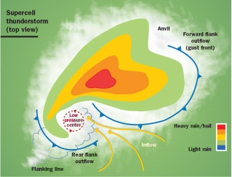 A supercell storm’s forward and rear-flank outflow boundaries act like mini-fronts and allow mini-low-pressure systems to form in the heart of the storm. Often, their radar signatures take on this classic shape.
 Supercells are self-perpetuating storms. They depend on strong vertical wind-speed and wind-directional shear to create their large, steady state, rotating updrafts. Winds near the surface may be 10 knots or so at the beginning of a supercell’s life, but up at 15,000 feet or so the winds may be blowing at 40 knots. At 30,000 feet, wind speeds can top 70 knots. And at the same time, the wind direction—relative to the direction of the storm’s ground track—is helping put a counterclockwise spin on the ever-growing mass of clouds. Having a fast-moving jet stream above the growing cell can really seal the deal on sparking an especially brutal supercell complex.
In large part, it’s a supercell’s huge downdrafts that perpetuate its life span. When the storm’s advancing, rainfall-heavy, forward-flanking downdraft hits the ground, a large portion of its outflow is ingested back into the base of the storm, in a kind of feedback loop. A rear-flanking downdraft, meanwhile, is created by winds aloft ramming into the entire vertical structure of the cell itself. Where the two downdrafts merge, a mini-front—and great instability—is created, on a magnitude that can initiate tornadoes.
The forward-flanking downdraft can cause other problems. After the downdraft hits the surface and spreads ahead of the storm, outflow boundaries can kick off a line of thunderstorms all by themselves. This happens because the warm air ahead of the outflow boundary is lifted and shoved forward as a gust front or squall line.
Mesoscale convective complexes (MCCs)
MCCs are large-scale thunderstorm complexes that can cover several counties—or entire states. They are primarily features of the central United States. They can start out suddenly as single thunderstorms, or be well advertised in advance—by propagating from a squall line ahead of a cold front, or by storms born of a supercell’s outflow boundary. In any case, these complexes are easily identified on radar imagery by both their size and their circular or oval shapes. To be more technical, meteorologists have given a few criteria for positively distinguishing MCCs. These include:
- A cirrus canopy with a diameter of 600 kilometers (about 373 statute miles) and cloud top temperatures of minus 32 degrees Celsius or less. If you’re surfing Internet weather sites, you can quickly determine cloud top temperatures by selecting infrared views, and consulting the color-coded legend for cloud temperatures.
- Core cloud top temperatures of minus 52 degrees Celsius or less, covering at least 50,000 square kilometers (about 31,000 square miles).
The above values must last for at least six hours. However, in many cases MCCs can last for 16 hours or more.
MCCs are fueled by the heat and moisture from low-level flows of air from the Gulf of Mexico. These low-level jet streams (LLJs) are nocturnal creatures. They pick up speed when the sun goes down and winds aloft at the 5,000-foot level “decouple” from surface winds. This decoupling is because of the effects of nighttime temperature inversions near the surface. These inversions stop the downward mixing of winds aloft, and set low-level winds aloft free to accelerate. The result is a warm, humid flow of air riding on southerly winds at speeds of 50 to 60 knots. The winds can travel as far north as the Dakotas, bringing fuel for MCCs. Sometimes, MCCs can regenerate from day to day, reenergizing at night with each daily LLJ.
Like the other well-organized thunderstorm types, MCCs should of course be given a very wide berth. Because of their size, circumnavigating them may be a chore. You’ll need plenty of fuel and, preferably, a fast airplane to help do the job. One good strategy may be to wait for an MCC to die down during the day, and to watch its daily progress until the nocturnal LLJ energy source dissipates.
Southerly flows
Mention of LLJs reminds me to offer one final word of caution for all types of summer flying. Be well aware of winds—especially strong winds—from a southerly direction. They can spell big trouble, and they can give you advance warning of danger to come.
We’ve already seen how warm LLJs signal the onset of MCCs. But strong southerly flows can also be your first hint that a cold front is approaching. The faster the flow, the more bombastic the frontal passage will be.
So if you’re keeping track of the winds aloft with your GPS, be spring-loaded to make a 180-degree turn or divert to an alternate airport if winds suddenly pick up out of the southerly points of the compass. All cold fronts typically have southerly winds ahead of them, but in thunderstorm season it’s the heat and moisture in that dynamic flow that sets the stage for lines and clusters of severe thunderstorms. Don’t say we didn’t warn you.
E-mail the author at [email protected].
Related Articles


