Safety Pilot Landmark Accidents: Always Another Dawn
A. Scott Crossfield offers his last lesson
 Test pilot, aeronautical pioneer and engineer, scientist, general aviation pilot, AOPA member, family man, nice guy. A. Scott Crossfield’s biography is impressive and although I never had the privilege of knowing him personally, I read his book, Always Another Dawn, which detailed his early life up through the design and flights of the X-15 rocket plane. As a research pilot for NACA, predecessor to NASA, he made aeronautical history on November 20, 1953, when he reached Mach 2, or more than 1,320 miles per hour, in the D-558-II Skyrocket. His aircraft was dropped from a B-29 at 32,000 feet and climbed to 72,000 feet before diving into the history books at more than twice the speed of sound. By any measure, he was a highly accomplished pilot and a superb individual. A. Scott Crossfield died in a thunderstorm near Ludville, Georgia, on April 19, 2006, at the controls of his Cessna 210. He was 84 years old.
A reaction by a number of pilots was, “If it can happen to someone like Crossfield, it can certainly happen to me.” Perhaps that’s the beginning of a nagging self-doubt that will lead some away from the cockpit. For others, they shrug it off as bad luck—the wrong place at the wrong time. Despite Crossfield’s book title, this dawn would be his last, but maybe there’s another way to look at it. Like the thousands of accidents that preceded it and, unfortunately, those accidents that will follow, there is a definite chain, an explanation and a way to avoid ending your life and aviation career on such a tragic note.
Morning thunder in the southland
The flight departed Prattville, Alabama, around 10 a.m. on a planned IFR route over Rome, Georgia; Snowbird, Tennessee; and Roanoke, Montebello, Casanova, and Manassas, Virginia. The requested cruise altitude was 11,000 feet. Prior to departure, Crossfield obtained several weather briefings. They described a large area of convective activity across the route and a forecast of considerable thunderstorm activity later in the day. Crossfield discussed the weather with an acquaintance, according to the NTSB, mentioning that he “might need to work his way around some weather but that it didn’t appear to be anything serious.”
The Cessna 210 climbed to 11,000 feet and everything proceeded routinely. ATC was well aware of the weather north of Atlanta and some airline flights were deviating west to avoid it while many departures were delayed. Crossfield’s flight was handed off to various en route sectors as he proceeded northeastward, but there was no discussion of thunderstorms. He checked on to the final frequency at 11:01 a.m. and was provided the local altimeter setting.
At 11:09 Crossfield transmitted, “Atlanta, this is Seven-Niner-X-Ray. I’d like to deviate south for weather.” The controller replied, “Six-Five-Seven-Niner-X-Ray, roger, we’ll show you deviating south for weather and your mode C indicates one one thousand five hundred.” Crossfield did not respond. At 11:10, about 30 seconds after a turn was started, radar contact was lost at 5,500 feet.
Before the Cessna entered the weather, the controller’s radarscope showed a band of moderate to extreme precipitation along the projected flight path, indicating a supercell thunderstorm. The aircraft’s final descent rate exceeded 12,000 feet per minute; the debris distribution was consistent with a low-altitude, in-flight breakup; and impact occurred in near vertical descent.
The wreckage was located on April 20, 2006, in remote mountainous terrain 3.3 nautical miles northwest of Ludville, Georgia.
The airplane
The 1960 Cessna 210A had externally braced wings, and Crossfield had owned it since 1989. The airframe and engine had accumulated 4,987 hours total time, with nearly 1,260 hours on the engine since its last major overhaul. An annual inspection was completed the month before the accident. The NTSB determined that the aircraft was operating normally at the time of the accident. Avionics included a BFGoodrich WX 950 stormscope, a Garmin GNC 250 GPS/Com, and a Garmin GNS 430 GPS/Com/Nav. The GNC 250 was limited to VFR flight only. The Garmin GNS 430 system was approved for IFR domestic flight, including en route and nonprecision approaches. Crossfield subscribed to XM Weather for satellite datalink weather, but the required antenna had not been installed. There were no pre-impact mechanical malfunctions noted.
The pilot
Crossfield held a commercial certificate with airplane single-engine land, multiengine land, and instrument ratings. His third-class medical certificate was issued in December 2004. On the medical certificate application, he reported a total flight experience that exceeded 9,000 hours. According to Crossfield’s logbook he had flown 95.5 hours during the previous 12 months, 28.5 hours during the prior six months, and 23.1 hours during the previous 30 days. During the prior year, all the flights were in the accident airplane and his last flight review was completed on August 27, 2004.
Total logged actual instrument flight time was 423.1 hours with an additional 106.0 hours using a view-limiting device. Like many of us, Crossfield had not spent much time in the clouds recently, with 5.4 hours of instrument flight time and two instrument approaches recorded during the previous 12 months. There were no instrument flight time or approaches shown during the six months before the accident and no instrument instruction or instrument proficiency check within the previous 12 months. By regulation 61.57 Crossfield was not legal to fly under IFR.
The weather
The accident occurred in an area of severe thunderstorms identified as a mesoscale convective system with intense to extreme intensities. The area forecast predicted instrument to marginal VFR conditions during the morning hours, with isolated severe thunderstorms and moderate rain expected after 10 a.m. with cloud tops reaching 43,000 feet. Crossfield obtained five Direct User Access Terminal (DUAT) weather briefings on April 18 and 19. The last briefing was recorded on the morning of the accident at about 6:56 a.m., which included warnings of convective weather later in the day. At 8:56 a.m., the National Weather Service (NWS) warned of a cluster of severe thunderstorms moving into northern Georgia. The area was expected to further destabilize by midday because of surface heating, enhancing the threat of organized severe thunderstorms. Hail, damaging winds, and tornadoes were all possible. It was not a good place to fly.
An in-flight weather advisory, convective sigmet 15E, was issued at about 10:55 a.m. for severe embedded thunderstorms over northern Georgia, portions of Alabama, Tennessee, and North Carolina. The system was moving southward at 35 knots with cloud tops reaching 45,000 feet. However, this advisory was never given to Crossfield.
Between 11 and 11:15 a.m. the National Lightning Detection Network detected 55 cloud-to-ground lightning strikes within 15 miles of the accident site. The strikes were clustered northwest to the north-northeast of the accident site and moving southward. No ground lightning strikes were detected within five miles of the accident site before the accident. It would have been interesting to see what the Stormscope was showing at the time.
Failure to communicate
Unlike years ago, virtually all ATC radar depicts precipitation in varying degrees. It has limitations but is far superior to the old days where lines and “Hs” gave a vague indication of where heavy rain might be. At en route centers such as Atlanta, a system known as Weather and Radar Processor (WARP) supplies controller displays with an overlay showing areas of moderate, heavy, and extreme intensity precipitation. In the worst case, the displayed precipitation can be as much as 12 minutes old in areas covered by only a single Nexrad radar.
However, single-site coverage is unusual, especially in parts of the country that experience frequent convective activity. Most en route controllers are looking at a composite picture of overlapping data received from several different Nexrad sites. Because the composite display is refreshed every time any of the overlapping sites supply new information, what the controller sees is typically four to six minutes old. Depending on the altitudes they are working, en route controllers can set altitude filters that show precipitation up to 24,000 feet; 24,000 to 33,000 feet; 33,000 to 60,000 feet; or at all levels.
The display does not show turbulence or thunderstorms, although heavy precipitation is roughly correlated with thunderstorm location. It takes some skill, interpretation, and understanding of the weather to get an accurate picture of where convective weather might be.
The NTSB review of Atlanta center communications confirmed that Crossfield was not provided any severe weather advisories (convective sigmet 15E was in effect at the time) nor was he advised of the radar-depicted weather displayed on the controller’s scope—both were required notifications. During the post-accident interview, the controller acknowledged that weather was “all over” his sector in varying intensities. He knew that northbound airline departures out of Atlanta were encountering thunderstorms and were “picking their way through holes in the weather.”
He acknowledged that controllers are required to issue adverse weather to pilots when depicted on their scopes, but he did not issue a warning because he felt that the weather display was unreliable. According to the NTSB accident debrief, this controller felt, “That pilots have a better idea of where adverse weather is, and that he expects them to inform him on what actions they need to take to avoid it.”
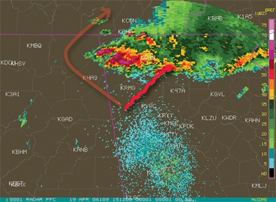 The red line shows Crossfield’s actual flight path. An “end-around” (orange line at left) would have avoided the entire thunderstorm area.
 At the time of the accident, the NTSB determined the controller’s workload consisted of Crossfield and one other airplane. Other extenuating circumstances such as limitations of radar, excessive traffic, frequency congestion, or workload issues that might have prevented the controller from issuing pertinent weather information were not present.
The Air Traffic Control Handbook 7110.65’s Chapter 2 describes controller responsibilities regarding weather. Priority one is separating traffic. But the directives further state that controllers should use good judgment and first perform the action that is most critical from a safety standpoint. Weather avoidance, particularly thunderstorms, is considered a high priority.
NTSB’s probable cause
The NTSB faults both the pilot and the controller in the tragic outcome of this flight: “The pilot’s failure to obtain updated en route weather information, which resulted in his continued instrument flight into a widespread area of severe convective activity, and the air traffic controller’s failure to provide adverse weather avoidance assistance, as required by Federal Aviation Administration directives, both of which led to the airplane’s encounter with a severe thunderstorm and subsequent loss of control.”
Analysis
There are several learning points. Crossfield knew he would be flying into an area of widespread severe thunderstorms based on his pre-departure briefing. He was airborne for more than an hour and did not ask for any updates from either ATC or flight service. Thunderstorms can move and develop rapidly so pilots should stay informed. There are many ways to do this.
We have no way of knowing what the Stormscope showed but if it was working properly, there would have been quite a display. The use of datalinked weather via satellite, while not a factor in this case since the equipment was not installed, might have been a very good way to keep up on the movement of the storm cluster. Although it might have been possible to pick a path through the system to the east, probably the best way to circumnavigate this would have been to proceed north until well into Tennessee and then proceed northeast toward Manassas. The inherent delay in datalink weather, which incidentally is similar to the delay that en route controllers have on their scopes, means that one should keep a healthy distance from rapidly moving and developing weather.
The attached insert (see page 151) provides general guidance to pilots—put it in your flight bag. There are several critical points. First, ATC generally does not know your flight conditions and whether you can see the weather well enough to avoid it. Tell them your flight conditions and ask for weather avoidance. This should be confirmed with every sector when thunderstorms are nearby. If something makes you uneasy, ask the controller what they are seeing and ask for vectors.
The controller in this case did not perform to standard and, just as with pilots, there will be skill differences within the ATC population. The good ones, and that is the vast majority, will do everything they can to help. If a controller is unable to help for whatever reason, including workload, modify your plan, ask lots of questions, and be very conservative on weather avoidance until you clear that sector. It may mean landing short or deviating extensively. Don’t wait too long.
Do not let yourself be put into weather above your capability. Even a “garden-variety” thunderstorm will be above the safety margins for those of us in light aircraft. If you’re not getting the help you need and the situation is getting out of hand, declare an emergency. Do not worry that the FAA is going to hammer you—they probably won’t, but Mother Nature most certainly will! Remember that you are the pilot-in-command, not ATC. They can provide information, and you can ask for suggestions, but the decisions are yours.
There will be times when some airspace is just not flyable. Having an aircraft equipped with weather detection equipment such as Stormscope, data-link, or even weather radar doesn’t change the atmospheric conditions. It just shows what may be an impossible situation. Don’t let the equipment lead you into a place you wouldn’t go without it. Technologically Advanced Aircraft (TAA) pilots pay heed! Even the airlines with large, superbly equipped aircraft; professional crews; dispatchers; and meteorology departments are periodically skunked, but GA has some flexibility that the airlines don’t. Go earlier, go later, add some quality flying time to your logbook by avoiding the whole area, divert, cancel.
The most critical flight is the next one, not the dozens, hundreds, or thousands already amassed. Experience can both help and hinder, creating dual mindsets that may lead the veteran pilot into difficulty. The most likely is complacency. The pilot has seen something many times before, has dealt with it successfully, and does not ascribe the appropriate level of concern to the problem. The second is that conditions that appear to be similar to those in the past are actually quite different and the chosen solution may not work as well as it did the last time. For those new to cross-country flying, and we all began there, take time to learn, ask lots of questions, fly with a mentor, and be very flexible in trip planning.
A. Scott Crossfield flew some of the most exotic and dangerous high performance aircraft ever built under the most perilous of circumstances. In considering his tremendous service to our nation, perhaps he has performed one final and noble sacrifice. His celebrity, skill, and experience overlaid onto this tragedy may draw enough attention from the entire aviation community that pilots, controllers, meteorologists, and system designers will learn—and many lives will be saved.
Bruce Landsberg is the executive director of the AOPA Air Safety Foundation.
From the AOPA Air Safety Foundation: Take the course!
In the past two years, the AOPA Air Safety Foundation has taken an aggressive stand on thunderstorm education. Here’s what we’ve been doing to help you avoid convective weather:
March 2006. We introduce a new online course for pilots detailing how to coordinate with ATC regarding thunderstorms.
March 2006. We introduce the Thunderstorms and ATC Safety Advisor.
June 2006. In AOPA Pilot we investigate a thunderstorm-related accident and offer the message: “Thunderstorms don’t give pilots a second chance.” See “ Safety Pilot Landmark Accidents: Working a Hole.”
November 2006. The NTSB joins us and introduces a thunderstorm safety alert available online.
March 2007. The AOPA Air Safety Foundation and the FAA send 184,000 Thunderstorms and ATC course DVDs to IFR-rated pilots.
March 2007. A joint effort from the AOPA Air Safety Foundation and the FAA: Thunderstorms and ATC. The controllers’ version is produced; it’s the first time ever that ASF produces a course for air traffic controllers explaining general aviation operations and limitations.
March 2008. We launch this thunderstorm avoidance campaign in conjunction with AOPA Pilot. See other related articles throughout this issue and insert on page 151.
Take the course! Talk to ATC! Take the course!

Related Articles


