
The following stories from the January 4, 2008, edition of AOPA ePilot were provided to AOPA members who expressed an interest in the particular subject areas. Any AOPA member can receive information tailored to their areas of interest by updating their preferences online.
My ePilot - Student Interest, Training Tips
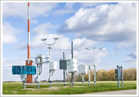
ASOS AND AWOS
 Technology has brought an enormous increase in the amount of information—especially weather information—at a pilot's fingertips. During the preflight briefing, you can study conditions at multiple reporting points, thanks to automated surface observation systems (ASOSs) and automated weather observation systems (AWOSs) at many airports. And those same systems are there to help you plan your arrival at many destinations. Include monitoring the station's report on your list of arrival duties before you contact the tower or request an airport advisory at nontowered airports. For more on using the CTAF at nontowered airports, see the Dec. 14, 2007, "Training Tips."
"Each ASOS is equipped to transmit weather via voice or computer through telephone or on VHF radio frequencies," the AOPA Air Safety Foundation's Safety Advisor about ASOS explains. Use the Safety Advisor to learn the different service levels of the various ASOS installations—and consider the circumstances under which the information provided is susceptible to inaccuracy or error. You'll also see an explanation of the differences between ASOS and AWOS installations. ASOS is more sophisticated, uses more computer processing, and has better quality control. Note that if a component of an ASOS's weather reporting capabilities is not operating, a code to that effect will appear in its published METAR. For instance, the code TSNO indicates that thunderstorm information is not available—definitely worth knowing during your preflight briefing.
Want to start watching weather trends at a possible destination, or just curious about what's happening at your home airport? Visit this FAA's ASOS Web page to check conditions.
With ASOS information so easily obtainable in a preflight weather briefing by telephone or computer, and from the air by radio, there's no reason not to acquire the most timely reports, then update as you near your destination [see your VFR aeronautical chart, AOPA's Airport Directory , or the Airport/Facility Directory for the correct frequency]. But also remember, as Ralph Butcher cautions in the Jan. 7, 2005, "Training Tips: Check the Sock," to survey the situation with your own eyes to get the total picture.
My ePilot - Training Product
HILTON SOFTWARE UPDATES 'WINGX'
Hilton Software, creator of WingX portable preflight preparation software, has released an updated version. The newest iteration, version 2.5, enables smartphone users to obtain reams of preflight data anywhere they can receive a cell phone signal. Along with the ability to connect to DUATS for preflight weather and flight restriction information, users can also access specific aircraft weight and balance information, check their personal flight currency, get the complete set of Federal Aviation Regulations, and calculate flight data with an E6B, to name a few. The program is compatible with Windows Mobile 5.0 and 6.0, and runs on devices such as Cingular's Treo line, Verizon's 6700 and Motorola Q, and T-Mobile's Dash. The program is $129.95 with a one-year subscription, and $49.95 to $99.95 for a yearly subscription. For more information, see the Web site, or call 866/429-4649.
Note: Products listed have not been evaluated by ePilot editors unless otherwise noted. AOPA assumes no responsibility for products or services listed or for claims or actions by manufacturers or vendors.
My ePilot - Student Interest, Final Exam
Question: While I was flying over an unfamiliar nontowered airport it seemed as though two different traffic pattern altitudes were being used—the lower altitude for airplanes like my Cessna 172 and the higher one by a corporate jet. I set up to enter the pattern at the lower altitude and kept my eye on the jet, but I wondered if I was missing something?
Answer: Typically, piston-powered airplanes like a Cessna 172, Piper Archer, or Cirrus SR20 will fly a 1,000-foot agl (above ground level) traffic pattern altitude while the heavier, higher performance jet/turboprop airplanes will fly a slightly higher altitude, say around 1,500 feet agl, in order to operate safely without causing conflict for other aircraft. When flying into an unfamiliar nontowered airport, you should consider flying at least 500 feet above the highest advertised traffic pattern altitude (TPA) in order to observe the airfield and windsock for the preferred runway in use. AOPA's Airport Directory Online lists airport TPAs that you can use for your preflight planning needs. Additional insight on traffic patterns is discussed in the online article "Looking for Traffic: Considerations for avoiding that midair collision."
Got a question for our technical services staff? E-mail to [email protected] or call the Pilot Information Center, 800/872-2672. Don't forget the online archive of "Final Exam" questions and answers, searchable by keyword or topic.


