Avionics: The Aera era begins
Touch-screen GPS completes fusion of airways and roadways
Existing Garmin products and Aera replacements:
- GPS MAP 296—Aera 500 ($799)
- GPS MAP 396—Aera 510 ($1,299)
- GPS MAP 495—Aera 550* ($1,499)
- GPS MAP 496—Aera 560* ($1,999)
*Aera 550 and 560 options include: High-resolution terrain data; SafeTaxi airport diagrams; AOPA’s Airport Directory; one-year subscriptions to obstacle, terrain, SafeTaxi, and AOPA updates.
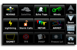
XM weather and TFR subscriptions can be displayed on Aera 510 and 560 models only.
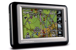 Pilots who have memorized Garmin’s peculiar button logic and carried it over from one portable GPS to another for years are in for a shock. The company’s new Aera handheld GPS line ditches it completely.
Instead, the slim, touch-screen GPS offers icons (above) to guide pilots through the process of creating, activating, and editing flight plans, and answering the myriad navigation, weather, TFR, and alternate airport questions that can arise on each trip. The familiar Procedure, Flight Plan, Clear, and even Direct To hard keys are gone, replaced by bright and cheery symbols that look as if they were lifted from a a smartphone or McDonald’s cash register.
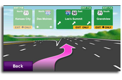 And when pilots reach their airport destinations, the Aera becomes a nüvi—a full automotive GPS with aural street-name callouts and optional weather overlays and real-time alternative routings around traffic tie-ups.
“This is the most intuitive product Garmin has ever made,” said Jim Alpiser, Garmin’s director of aviation aftermarket sales. “It’s a paradigm shift for our existing customers. But we haven’t taken anything away. The Aera has all the capability of any of our other aviation handhelds, and more—and it’s much easier to use.”
For Garmin, the Aera (pronounced AIR-uh) completes the fusion between the company’s aviation and automotive products. The Aera’s rectangular frame is identical to the zumo 660, Garmin’s high-end motorcycle GPS. The rugged hardware is water resistant (Garmin says that it can withstand 30 minutes submerged under one meter of water), oil- or fuel-soaked fingers won’t harm the screen, and it’s built to withstand heat, cold, and vibration. The roads database comes straight from Garmin’s popular nüvi.
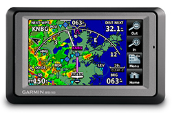 The Aera’s 4.3-inch diagonal screen is one of its strong points. It’s easily readable in direct sunlight and takes much from the premium GPSMAP 696 that preceded it.
Every Aera comes with a yoke mount for airplanes and a sticky windshield/dashboard mount for cars. But the automotive mount is so versatile, and the Aera itself is so slim, that it’s easy to picture pilots using auto mounts in airplanes.
The Aera’s moving map shifts easily between VFR and IFR use. It shows airways and intersections in the IFR mode—a big plus for pilots on the East Coast, where airway routings are the ATC norm. The airways also show MEA information (when prompted), and the Aera provides terrain warnings on both the VFR and IFR map screens. When linked to traffic systems, the Aera also can display aerial traffic warnings. (The obstacle, terrain, and traffic warnings appear in a pop-up screen on the lower left portion of the display.)
 Garmin has long used touch screens in automotive products, and the company offered a short-lived, touch-screen aviation GPS in 2005.
Bendix/King, Garmin’s cross-town rival in Olathe, Kansas, upped the ante last year with its AV8OR, and this year’s AV8OR ACE, products whose thoughtful engineering and popularity demonstrated the utility of touch-screen, aviation/automotive GPSs (see “Avionics: It Flies and Drives,” January 2009 AOPA Pilot). The ACE combines a touch screen with four hard keys, and Bendix/King desensitized the screen to reduce inadvertent activation in bouncy cockpits.
Garmin officials say they are convinced that pilots are ready to do away with buttons and rocker switches forever in favor of pure touch screens. The change eliminates the multiple screen “pages” and sub-menus on other Garmin aviation products. The Aera also offers a simple “back” option to return to the previous screen, and holding “back” for a few seconds is a get-out-of-jail-free card that brings up the home page.
The Aera (like the AV8OR and ACE) also has an iPhone-inspired touch-and-drag feature on its map screens and a QWERTY key pad for data entry.
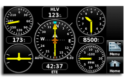 All Aeras can show Garmin’s “panel/HSI” page, a clever display that recreates aircraft flight instruments with GPS-derived data (groundspeed, altitude, vertical speed, heading/track, distance, time en route, and turn coordinator). The panel page is updated five times a second (the same update rate as the GPSMAP 495/496 and 696) and gives pilots a realistic chance of maintaining aircraft control and situational awareness—and even flying an instrument approach—if every instrument in the airplane suddenly failed during flight.
The Aera 550 and 560 include Garmin SafeTaxi airport diagrams and AOPA’s Airport Directory.
Internal Aera batteries can last up to five hours without recharging. But when connected to an XM antenna, that number is cut in half. And in a worst-case scenario (daylight and a colorful display that draws a lot of electrical current), battery life drops to about two hours. Each Aera comes with cigarette-lighter power adaptor.
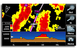 XM subscriptions that deliver weather and TFR information range in price from $30 to $100 a month.
Garmin ended 296 and 396 production in October just before the Aera was unveiled at AOPA Aviation Summit in Tampa, Florida, in November. Sales of the 496 could continue about one year. The company will continue to support legacy products with online updates.
But the company that invented the handheld aviation GPS has reached a turning point, and the Aera era has arrived.
E-mail the author at [email protected].


