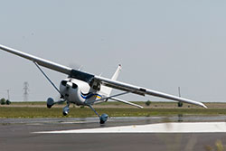
We’ve all heard the expression about March: It comes in like a lion and goes out like a lamb. Why does March trigger strong winds in some parts of the country? With the change of seasons—the advent of spring—weather fronts are passing through, and the contrast between these fronts is greater. An influx of warmer air means temperature gradients between air masses contrast greatly, and that means wind.
Gusty, blustery conditions could be a factor on your next flight. But you can get up to speed on handling winds with AOPA’s help. To get the bigger weather picture, start with the AOPA Air Safety Foundation’s Weather Wise: Air Masses and Fronts interactive course. By understanding the forces that create winds, a pilot can anticipate changes, avoid potentially hazardous conditions, and even use pressure gradients to plan a cross-country flight so as to maximize tailwinds.
Even if you’re remaining within the pattern, you’ll want to brush up on takeoffs and landings in gusty conditions. Review the foundation’s Mastering Takeoffs and Landings Safety Advisor for management tips and convenient rules of thumb. Here’s one: Landing in gusty conditions? Add half the gust factor to your airspeed as a margin of safety.
Of course, windy conditions can persist throughout the year and take different forms, such as wind shear or turbulence. All will test a pilot’s measure of skill. Be sure to review the articles found in the Windy Flight Operations aviation subject report compiled by AOPA’s Pilot Information Center. These articles discuss the wind’s impact on all phases of flight—with plenty of attention paid to that perennial favorite, the crosswind—and include lots of guidance from experienced pilots.


