| The following stories from the July 30, 2010, edition of AOPA ePilot were provided to AOPA members who expressed an interest in the particular subject areas. Any AOPA member can receive information tailored to their areas of interest by updating their preferences online. |
training tipsField elevation
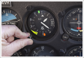
There are multiple reasons to do so. That’s why many airports include airport elevation information on the big airport sign you see when you taxi in or drive up to the gate. For example, correctly setting your altimeter to the current barometric pressure isn’t complete until you verify that the instrument indicates the field elevation. What if there is a discrepancy? “Note the variation between the known field elevation and the altimeter indication. If this variation is in the order of plus or minus 75 feet, the accuracy of the altimeter is questionable and the problem should be referred to an appropriately rated repair station for evaluation and possible correction,” says Chapter 7 of the Aeronautical Information Manual .
A 3,300-foot runway length may accommodate just about any approach or departure for your trainer at sea level. But that same runway length becomes a much closer call at a high elevation, especially when high-density-altitude conditions—that is, conditions causing longer-than-normal takeoff runs and a reduced rate of climb for non-turbocharged aircraft—prevail. A high field elevation usually means that the airport sits in mountainous terrain. If so, you could encounter a variety of other conditions rarely seen in the lowlands, as AOPA Pilot Senior Editor Dave Hirschman wrote about Colorado’s 5,916-foot-high Glenwood Springs airport in the April 2009 AOPA Pilot feature “ Mountain flying adventure.” “The runway is 3,300 feet long with trees at each end. A narrow and twisting canyon guards it, and like so many Colorado mountain airports, weather and winds sometimes demand one-way runway operations.”
Those are a few tips about why field elevation is as valuable a bit of information as it is easy to acquire. Don’t underestimate its importance when you plan that next cross-country! training productsBeyerdynamic HS400Beyerdynamic introduced a new headset this week at EAA AirVenture in Oshkosh. The HS400 is a passive noise attenuating headset with a separate audio control box that includes a jack for auxiliary audio or a cell phone. The headset, which can be fully customized, starts at $429.
Note: Products listed have not been evaluated by ePilot editors unless otherwise noted. AOPA assumes no responsibility for products or services listed or for claims or actions by manufacturers or vendors. final examQuestion: What is a MOA, and can I fly through it?
Answer: MOA stands for “military operations area” and consists of airspace with specific vertical and lateral limits established for the purpose of separating military training activities from IFR traffic. Such activities as formation training, air combat tactics, and low-altitude high speed operations are common. When a MOA is active, IFR traffic may be cleared through as long as ATC can maintain IFR separation. Otherwise IFR traffic will be rerouted around the MOA. No permission is needed to fly VFR through a MOA; however, VFR traffic should proceed with extreme caution. It is a good idea to check the status of a MOA with flight service and also contact the controlling agency for traffic advisories before penetrating the airspace. For more information, check out AOPA Air Safety Foundation’s online interactive course, Mission Possible: Navigating Today’s Special Use Airspace .
Got a question for our technical services staff? E-mail [email protected] or call the Pilot Information Center, 800/872-2672. Don’t forget the online archive of “Final Exam” questions and answers, searchable by keyword or topic. |
 It’s one of the first facts you learn about an airport when you locate its symbol on a sectional chart or look it up in a directory—but do you fully take an airport’s elevation above sea level into account during flight planning?

