Epic Flights: Greenland adventure
Flying the vast frozen Arctic
Photography by Chris Rose
Towering and timeless, the icy peaks of Greenland’s remote west coast rise slowly into view at a distance of more than 150 miles.
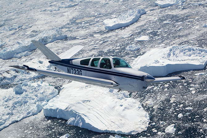
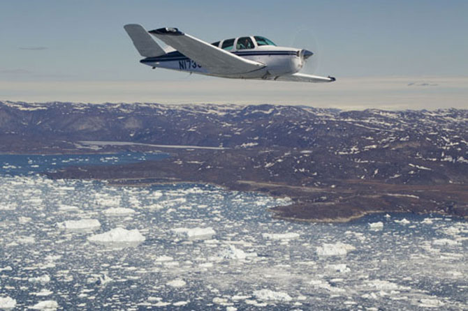
 The sight of land—even harsh, imposing, desolate land—brings welcome relief from crossing over the Davis Strait, a 450-nm body of deep, ice-strewn ocean that separates northernmost Canada and Greenland. I’m flying with Adrian Eichhorn in his beautifully restored 1962 Beechcraft V35P Bonanza, and we’re part of a group of three Bonanzas that has come to this exotic place for absolutely no practical purpose.
We’re not ferrying airplanes to Europe, searching for minerals or artifacts, installing radar sites, or doing the many other important tasks that have brought Americans to this polar region, on and off, for decades. We’re here because we share the same desire, ability, and curiosity to come, and the unmodified, single-engine general aviation airplanes we’re flying are well capable of covering the distance.
“I can’t tell you how many times I’ve flown over Greenland in jets at high altitude and wondered how amazing it would be to see this place from the vantage point of my own airplane,” said Eichhorn, an airline pilot with a lifelong passion for general aviation. “It’s always been my dream to do this trip, and now we’re doing it.”
As we get closer, the mountains, valleys, and fjords present themselves in sharp relief, and our group keeps up a steady banter of gallows humor on the radio—just as we have throughout the three-hour crossing, and the 2,000 nautical miles we have flown to reach this place from the U.S. East Coast.
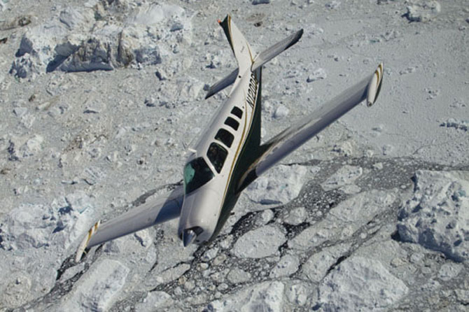
Ernie and Paula Benner of Berryville, Virginia, are flying their A36 with AOPA Photographer Chris Rose; and Elliott Schiffman and Paul Carroll of Connecticut and Rhode Island, respectively, are traveling in Schiffman’s F33.
Schiffman dubiously claims to have spotted seals on some of the ice floes more than a mile below, and Ernie, a retired Army officer, chuckles aloud.
“Good thing I brought my knife because those seals are part of my survival plan,” he deadpans.
Eichhorn has been munching snacks and chimes in that “Peanut M&Ms are my survival plan.”
Carroll wryly informs us that “Elliott is my survival plan” (and thereby earns the nickname “Cannibal” for the duration of the trip).
I’ve been ranging out the scale of the GPS moving map so that the Greenland shore appears closer and the Davis Strait seems relatively small. On a 200-mile scale, the airplane symbol showing our position is never more than an inch from land. Noting my unease, Eichhorn chooses the midpoint of our crossing to reveal some little-known facts about his 50-year-old airplane. Sure, it’s an immaculate showpiece, he says, but it’s also been landed gear-up twice, had 27 owners, and the engine (a Continental IO-470N) that Eichhorn overhauled himself in 1998 is the only engine he’s ever rebuilt (Eichhorn is an A&P/IA).


Thanks for sharing
A blanket of fog envelopes the Greenland coast, but our destination at Sonderstrom (BGSF), a former U.S. air base, is 80 miles inland, and the automated weather report tells of unlimited visibility, a 10-knot west wind, and a seemingly impossible temperature/dew point spread of 70 degrees Fahrenheit. (I listen to the recording again to confirm the bizarre numbers.)
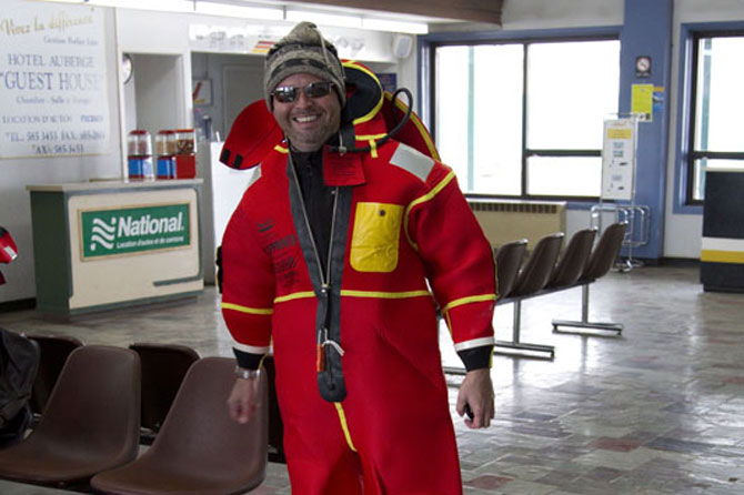
The outside air temperate is 40 degrees F, and even with the air vents full open, I’m sweating under the immersion suit I’ve been wearing the past four hours. I tug on the neck to allow some space for cool air to get through, but it’s of little use. We cross the coastline and follow the deep blue river up the fjord that leads to Sonderstrom, and the east/west runway is clearly in sight more than 30 miles away.
The plan
Eichhorn planned to make this trip with a fellow Bonanza pilot eight years ago, but his friend canceled on the morning they were scheduled to depart and Eichhorn reluctantly scrubbed, too. This time, he vowed to make the trip alone if he had to, but it turns out he had plenty of company.
When Eichhorn invited Rose and me to come along to document the trip, it sounded intriguing. Neither of us had ever been to that part of the world, and I had always wanted to fly GA across an ocean (or in this case, part of an ocean and back). Eichhorn’s enthusiasm for this adventure, and his certainty that everything would work as planned, were persuasive, even though his delivery was a bit unconventional.
His pitch went something like: “How would you like to fly a really long way over some of the world’s roughest terrain in a single-engine, piston airplane; stay in some pretty marginal, overpriced hotels; and buy some of the most expensive avgas in the world? Are you in?”
It took about five seconds for me to say yes. Ernie was sold on the spot, and Paula showed no hesitation, either. Schiffman signed on via email, and Carroll joined him as a last-minute addition.
And so it begins
We plan to make the entire 4,000-nm round trip in six days, but the vagaries of Arctic weather require allotting much more time than that.
In the weeks leading up to departure, most of the participants meet in person, divide the responsibilities for planning, and coordinate via email. Eichhorn sets the route after consulting with numerous ferry pilots and compiles charts and approach plates; Ernie chases down avgas (a complicated task in areas where most airplanes burn jet fuel—avgas is only available in 55-gallon drums, and fuel transfer pumps are scarce). I arrange for places to stay.
We assemble in Bangor, Maine, on a rainy Monday, where Maine Aero Services provides a one-stop shop for immersion suits, inflatable rafts, and other equipment for Atlantic crossings. We file our eAPIS computerized Customs forms and set out for Sept-Iles, Quebec, where we clear Canadian customs that afternoon. The next day we fly to Schefferville, a small mining town on the Quebec/Labrador border, and buy fuel from drums carried in the bed of a pickup truck, and then continue north to Iqaluit (e-Kallawit) on Canada’s far north Baffin Island (see “Flying in the True North,” December 2010 AOPA Pilot).
We tune in the air-to-air frequency (126.7 MHz) that pilots use in this region, but since almost all the conversation is in French, listening adds little to our situational awareness. The names of some of the places we overfly (Riviére a la Baleine, Lac Gabriel, and Baie Aux Baleines) reflect the French-Canadian influence in this maritime area.
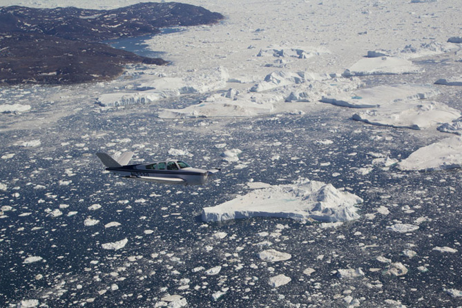
Our first water crossing is the Hudson Strait, a 140-mile expanse at its narrowest point. Blue water and ice floes hint at bigger challenges to come.
We fly VFR in crystal-clear, still air, and the terrain in northern Quebec slowly becomes rocky and then completely treeless. Even in mid-June, patches of snow thicken to complete coverage at Iqaluit. That night at the Frobisher Inn, sleep is difficult because of the excitement of the over-water portion of the trip still ahead of us, and the fact that it is light 24 hours. Sunshine streams into our hotel rooms despite closed curtains.
Another planet
On the morning of our departure for Greenland, we pull on immersion suits, place life rafts where they can be reached quickly in case of a water landing, perform especially detailed preflight inspections, and hope for the best.
We leave Iqaluit (CYFB) as a flight of three flying VFR and climb to 7,500 feet as we approach the coast.
We check in with Arctic Control and give periodic position reports along the way. It’s surprising how clear and strong the ATC transmissions come through on our standard VHF radios hundreds of miles from the land-based transmitters.
A passing airline pilot on the way from Dubai in the United Arab Emirates to Houston, Texas, checks in to wish us well. He expects to land in about four hours, roughly the same time we anticipate touching down in Greenland.
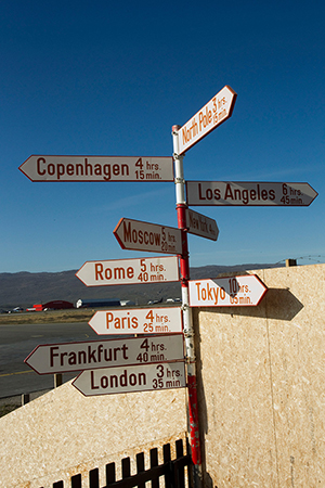
Halfway across the Davis Strait and about 220 nm from our destination, we check in with Iceland Control, and the Scandinavian controller’s clipped English reinforces the reality that we’re closer to Europe now than the United States. We inform him of our position and planned arrival time. It’s critical that we arrive by 4:30 p.m. local time because that’s when the control tower closes, and Greenland officials are known to impose massive fines for landing at “closed” airports.
The magenta course line on the moving map shows a distinct curve in our path at this far northern latitude, and the wet compass varies up to 30 degrees. When air traffic controllers speak of headings, they add the words “magnetic” or “true”—a clarification that would be meaningless in the world’s more central latitudes.
We think about the air crews who pioneered and built up these routes in the 1930s and 1940s, and the skill and courage it must have taken to navigate such vast, trackless, and lonely expanses with primitive navigation equipment and no reliable weather reporting.
The ocean ahead is a mix of deep blue water and snow-covered ice that mirrors the sky in color and texture. I scan the horizon for the first sight of land, and it emerges subtly at a distance of just under 200 nm. At first it is impossible to tell whether the apparition is cloud or ice. But dark shading and rough contours soon confirm that the object on the horizon really is land. And even though we’re traveling at 150 knots toward a place that’s already in sight, our arrival is still more than an hour away.
The uniform temperature of the water below us and the air mass we’re flying through is so stable that the air at 7,500 feet remains absolutely placid. The Bonanza is rigged perfectly, and even though it doesn’t contain an autopilot, holding a heading and altitude is simple.
We marvel at otherworldly landscape as it comes sharply into focus.
“This doesn’t look like another country,” Eichhorn says. “This looks like another planet.”
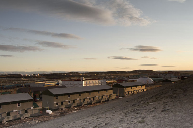
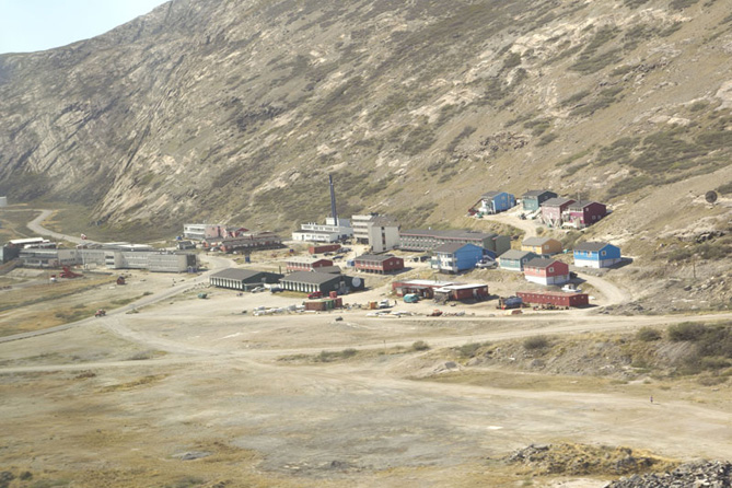
Crossing the coast we feel the first light chop we’ve experienced in hundreds of miles. The tower at Sonderstrom clears us to land, and we follow the A36 to a smooth touchdown on an expansive runway made for Cold War bombers and jet transports. The facility was known as Bluie West Eight when the U.S. Army founded it in 1941. Later it was renamed Sonderstrom Air Base, and in the early 1990s it was handed over to Greenland and now goes by its Inuit name, Kangerlussuaq (which means “big fjord”).
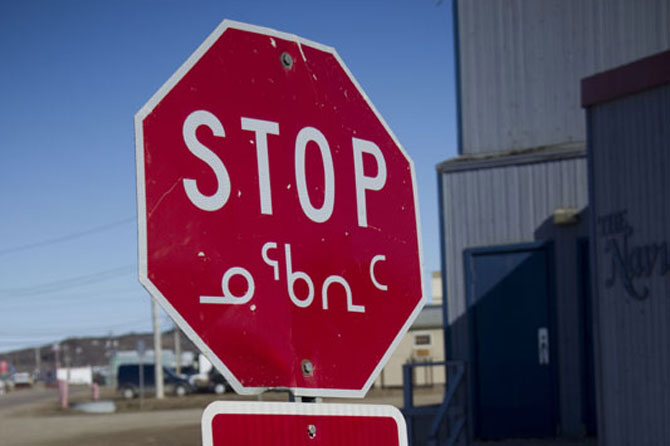
Many of the former Danish names here have been replaced by native titles. To Americans, the only thing the languages have in common is that both are virtually unpronounceable. The airport, one of the largest and best equipped in Greenland, is far and away the biggest thing going in Kangerlussuaq, a town of fewer than 600 people. We check into the airport hotel and exhaustion allows us to sleep despite sparkling sunshine at midnight.
Unforgettable
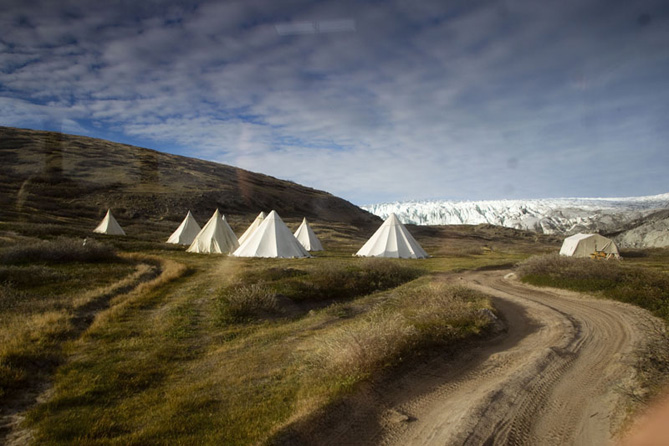
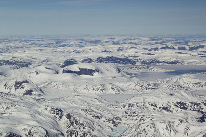
The next two days bring a series of unforgettable photo flights over the ice cap and incomparable, ice-jeweled Disko Bay 150 nm to our north. We overfly the undulating ice cap that contains fissures hundreds of feet wide and perhaps thousands of feet deep. Rivers of meltwater carve plunging paths in, around, and through the ice like liquid cutting torches. Unknowable quantities of perfectly pure water collect in temporary, electric blue lakes atop glaciers.
After landing, we tour the Russell Glacier on foot and watch, hear, and feel the colossal impact as ice blocks the size of boulders crash into violent torrents of water that carry them plunging to the coast. The incomprehensible scale of this place and the unfathomable power of the natural forces unleashed here make lasting impressions.
When we retrace our path on the flight home, the weather for our second crossing of the Davis Strait is, if possible, even better than the first. The sight of three Bonanzas in a loose V formation, seemingly stationary while the vastness of the frozen Arctic passes beneath, is a vision that will stay with me, and the rest of our party, a very long time. The places we traveled together are recorded in memory and photos, yet even after the fact, the experience seems somewhat unreal.
“Did you ever imagine when you learned to fly that you would take a GA airplane somewhere like this?” Eichhorn says. “I had high hopes and expectations for this trip, but the actual experience far surpasses them.”
His certainty that everything would work out well mechanically and logistically turned out to be well founded. All three airplanes performed flawlessly during the roughly 40 hours of flight from beginning to end. There were no blown tires, fouled spark plugs, or broken alternator belts, even though we had done our best to prepare for those kinds of things. The avionics in each airplane performed solidly, and we were able to purchase avgas at each of our planned stops. The weather, our biggest variable, was completely favorable in northern Canada and Greenland (although we encountered plenty of clouds in Maine and southern Canada).
“Are we lucky or what?” Eichhorn says after touching down at AOPA’s home base in Frederick, Maryland.
I assume he is referring to the factors listed above, but his mind is on bigger issues.
“Having the freedom to own our own airplanes and fly them internationally—those are concepts that would be completely unimaginable to most people in the world today. When you realize how capable these airplanes really are, and how many places they put within our reach, you can never look at cross-country flying in quite the same way again.
“The only downside to this trip,” he says, “is that it makes me want to do more.”
Email the author at [email protected].


