Avionics: First impressions
WingX Pro7: Syn viz for the iPad
Of all the new aviation capabilities being added to the iPad, synthetic vision is among the most useful and promising. Fellow pilots may doubt the value of synthetic vision, but such suspicion tends to disappear the first time they find themselves on an unfamiliar approach when the weather is down to minimums and rain is beating against the windshield. At such times, it’s nice to “see” the airport, the landing runway, and the pathway to it—and syn vis doubters become believers.
Hilton Software is the first to offer synthetic vision for the iPad with its WingX Pro7, an exceptionally capable program that—for $99—adds an extremely limited form of GPS-derived synthetic vision, lacking both pitch and bank information. However, the addition of an AHRS G mini air data computer made by Levil Technology changes the picture by allowing WingX Pro7 to show syn vis on the iPad with pitch and bank. And connecting the AHRS G mini to the aircraft’s pitot/static system allows the iPad to show indicated airspeed (instead of groundspeed) and barometric altitude (instead of GPS altitude).
AOPA Pilot flew the WingX Pro7/AHRS G mini combination in the AOPA 2012 Sweepstakes “Tougher Than A Tornado” Husky recently, and the results were impressive. The system is easy to install (without the pitot/static connections) and the iPad showed the surrounding terrain with tremendous fidelity, and pitch and bank changes instantly. In case of an avionics or electrical failure, syn vis and the WingX Pro7’s split-screen moving map could provide a potentially lifesaving means of staying oriented and navigating to an airport. And the system can operate on its own power for many hours, or connect to the aircraft’s electrical system and constantly recharge.
But iPad-based syn vis isn’t nearly as refined as the FAA-certified glass panel systems (which cost tens of thousands of dollars), or some Experimental systems (that start out at about $5,000). For an iPad owner who already uses the tablet in the cockpit for charts and navigation, however, the addition of syn vis with pitch and bank information for $900 ($99 for WingX Pro7 and $800 for the AHRS G mini) is a compelling value.
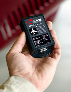 The Levil AHRS G mini can be mounted in the aircraft with just two screws. It provides pitch and bank information to iPads, iPhones, or other tablets via a wireless connection. Although not FAA certified, it can increase pilot situational awareness when displayed on a portable device.
The AHRS G mini is about the size of a cigarette pack and must be mounted so that it is perfectly horizontal when the airplane is in level flight. In the Tornado Husky, simply putting it on the wood cockpit floor and securing it with two screws was satisfactory. Once powered on, it communicated perfectly with the iPad via a wireless WiFi connection.
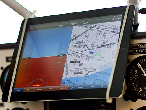
I tried several different mounting positions for the iPad itself and finally settled on a landscape (horizontal) view in the front cockpit. This iPad2 has an internal GPS receiver, and I added a Bad Elf external GPS for redundancy. (It also has an anti-reflective screen cover that hardly seems worth the $30 I paid for it, since daylight readability remains the iPad’s glaring weakness.)
The iPad showed the aircraft’s position on the runway surface with great accuracy—but limited detail. Runways aren’t numbered, for example, or striped as they are in some other systems. The hard surfaces appear on the iPad as solid black rectangular forms.
Once airborne, the AHRS and iPad had no trouble keeping up with aggressive turns, steep banks, and pitch changes. Nothing I could do with the stick and rudder bothered it in the slightest, and the screen’s rapid refresh rate easily kept up with the maneuvers. (The iPad user must remember to dig into the settings before flight, however, to lock the screen and prevent it from jumping between landscape and portrait modes. Slide the small switch on the top right side to do the same thing. Also, set the altitude to field elevation so a momentarily inaccurate GPS signal won’t make the iPad think it’s underground, a type of confusion that plays havoc with the display.)
The GPS and terrain database worked smoothly, so the iPad display matched the outside world, and the magneto-meter inside the AHRS G mini was accurate throughout. Close proximity to terrain showed up in color shading: yellow at first for terrain within 1,000 feet, then red for terrain within 100 feet. But the map scale was zoomed far out and, to steal a line from the side mirrors on my car, objects shown on the iPad “may be closer than they appear.” (Hilton Software is adding a pinch-zoom function to future versions to address this issue.)Large rivers showed up in a languid blue shade while smaller ones didn’t appear at all.
Returning to the airport, the facility itself isn’t as prominent as on other syn vis displays. There are no golf-course-style flags to mark airports as on some Garmin and Avidyne products, nor are there symbols to identify when airports are operating under VFR, marginal VFR, IFR, or low IFR conditions. There also are no “highway-in-the-sky” magenta boxes to fly through en route, or green ones during approach. The helpful green dot that shows the airplane’s trajectory (also known as the velocity vector, pathway marker, or simply “meatball”) available on Garmin, Avidyne, and Aspen systems is absent from the WingX Pro7 for the iPad—and I never fully appreciated that green dot until it was gone.
The iPad syn vis does have a zero-pitch line that shows where the airplane’s path would intersect with surrounding terrain, a useful feature in quickly determining the airplane’s orientation.
Hilton Software and Levil Technology moved amazingly fast to offer syn vis on the iPad, and Hilton is hard at work creating even more related offerings. The California firm plans to allow pilots to use the iPad’s pinch-zoom screen to look ahead in flight, for example, and familiarize themselves with terrain by offering a full, 360-degree field of view.
Syn vis for the iPad (and the iPhone) offers an exciting new enhancement to existing apps at an attractive price. It’s also certain that other software firms will follow with their own versions of GPS-derived synthetic vision for the iPad, and the pace of upgrades to the ubiquitous tablet’s already considerable in-flight capabilities is sure to accelerate. With tools like this, the prospect of partial-panel IFR flight becomes far less daunting.
Email the author at [email protected].


