| The following stories from the Feb. 11, 2011, edition of AOPA ePilot were provided to AOPA members who expressed an interest in the particular subject areas. Any AOPA member can receive information tailored to their areas of interest by updating their preferences online. |
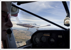
training tipsIt’s still see and avoid Even in the age of airborne collision avoidance technology, extensive radar coverage, and eventually, the traffic reporting capabilities of automatic dependent surveillance-broadcast (ADS-B), the see-and-avoid doctrine remains the cornerstone of flying under visual conditions. The term may sound quaint, but see and avoid carries official weight. “The rules for maintaining separation from other aircraft during VFR operations are spelled out in FAR 91.113(b): ‘When weather conditions permit, regardless of whether an operation is conducted under instrument flight rules or visual flight rules, vigilance shall be maintained by each person operating an aircraft so as to see and avoid other aircraft,’” explains the Air Safety Institute’s Safety Advisor Collision Avoidance: Strategies and Tactics . You may know from ground school study that see and avoid means a lot more than just looking around. It calls on pilots to recognize known collision-risk areas such as operations in nontowered airport traffic patterns, and flight in the vicinity of VORs, where aircraft tracking inbound to the station tend to converge. It calls on pilots to be methodical in their technique of scanning for other traffic. Are you familiar with your aircraft’s blind spots? Every aircraft has them, as illustrated in this brief video. During your sessions practicing maneuvers, see and avoid means performing effective clearing turns. Here’s how. Being a safe see-and-avoid aviator means being aware that different pilots may use different methods for their arrivals and departures—an age-old topic for discussion reinvigorated by the January 2011 AOPA Pilot debate “Dogfight: Pattern Entry” between Editor at Large Tom Horne and Senior Editor Dave Hirschman. Everyone agrees that services like radar are a big help, but the pilot must interact with it correctly—a skill probed in this sample question from the Private Pilot Knowledge Test: “An ATC radar facility issues the following advisory to a pilot flying north in a calm wind: What was your answer? Is this traffic a potential conflict? Why was the wind condition part of the question? All to be discussed in the next installment. Until then, view the Air Safety Institute’s collision avoidance Webinar, “Look, Listen, and Live: Tips and Techniques for Avoiding Midair Mishaps,” for additional insights. training productsVFRmap.comThe recently launched VFRmap.com is a free online source of VFR and IFR charts and airport/facility directory data. Scroll around and zoom in or out on the charts. You also can choose five kinds of charts from a pulldown menu: hybrid VFR (a combination of world aeronautical charts, sectional, and terminal); VFR sectional; WAC; IFR en route high-altitude charts; and low IFR (a combination of IFR en route low-altitude charts and IFR area charts). You can’t draw a course on these charts, but the site is a quick and easy reference for a variety of uses. Note: Products listed have not been evaluated by ePilot editors unless otherwise noted. AOPA assumes no responsibility for products or services listed or for claims or actions by manufacturers or vendors. final exam
Question: Can panel-mounted VFR GPS and/or handheld GPS systems be used during IFR operations?
Answer: Yes, they can be used during IFR operations, but only as an aid to situational awareness. VFR GPS and/or handheld GPS systems are not approved for IFR navigation or instrument approaches. They should also not be used as a primary reference during instrument flight. Most VFR GPS receivers including all handheld units do not have receiver autonomous integrity monitoring, or RAIM, alerting capability. This means that a pilot might not be aware that the GPS signal had deteriorated to such point that a navigation error could occur. For more information on the use of both VFR and IFR GPS units, read the Air Safety Institute’s Safety Advisor, GPS from the Ground Up . Then test your knowledge with the institute’s GPS for VFR Operations and GPS for IFR Operations online courses.
Got a question for our technical services staff? E-mail [email protected] or call the Pilot Information Center, 800/872-2672. Don’t forget the online archive of “Final Exam” questions and answers, searchable by keyword or topic. |
 Radar is reliable, and radios are reassuring, but watching out for conflicting traffic still mostly depends on another traffic-detection device in the cockpit: your eyes.

