Wx Watch: Checking the weather
Forecasts you can count on—and count out
 The aviation weather forecasts we receive from flight service are, for the most part, accurate and useful for our short- and long-term flight planning purposes. Sure, there are exceptions. Some of them are functions of the centralized nature of the flight service infrastructure. Not too long ago, when you called flight service you reached a briefer local to your area, who knew from experience the indigenous weather patterns and trends—in other words, the climatology of your area. Did that make them infallible resources? Of course not.
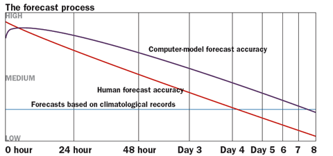
Today we have two Direct User Access Terminal system (DUATs) providers via the Internet, the Aviation Digital Data Service (ADDS) website, AOPA’s online weather, private Internet weather information websites, eight automated flight service stations (AFSS), plus a number of FAA-run flight service stations in Alaska. That’s a huge escalation in weather data availability, but the briefer answering an AFSS call may be sitting in a room thousands of miles away. There goes the local savvy, you might say—and you’d be correct in some cases. But there have always been limitations on forecast accuracy. Today’s no different, but forecast accuracy is definitely improving. The general opinion is that today’s five-day forecasts are as accurate as the three-day forecasts put out 10 years ago.
Alphabet soup
Where does all this weather information come from? If you think it comes from the AFSSs, ADDS, or DUATS you’d only be partially correct. Those venues are the final suppliers. The original analyses and forecasts come from a bewildering alphabet soup of federal meteorological bureaucracy:
- The National Weather Service’s (NWS) National Centers for Environmental Prediction (NCEP) in Camp Springs, Maryland, produces computer-generated forecast models covering a wide range of conditions. One set of products—MOS (Model Output Statistics)—gives the groundwork for TAFs and other forecasts.
- NCEP’s Hydrometeorological Prediction Center (HPC) concentrates on precipitation forecasts.
- The Storm Prediction Center (SPC) in Norman, Oklahoma, focuses on convective weather forecasts and related products.
- The Tropical Prediction Center (TPC) in Miami makes tropical weather observations and forecasts.
- The National Oceanic and Atmospheric Administration (NOAA) provides satellite imagery via its National Environmental Satellite Data and Information Service (NESDIS) and Satellite Analysis Branch (SAB).
- The Aviation Weather Center (AWC) in Kansas City, Missouri, produces airmets, sigmets, area forecasts, plus the Collaborative Convective Forecast Product and Current Icing Product (CIP) and Forecast Icing Potential (FIP) graphic tools.
- NWS’s Weather Forecast Offices (WFOs) across the nation produce terminal aerodrome forecasts (TAFs) and transcribed weather en route broadcasts (TWEBs).
- Center Weather Service Units (CWSU), co-located at Air Route Traffic Control Centers, produce Center Weather Advisories (CWA) and Meteorological Impact Statements (MIS)—which are primarily aimed at those on IFR flight plans.
Mission impossible?
All the weather analysis and forecasting computer models in the world still can’t bat a thousand. They may be getting better all the time, but perfection? Never. The job’s too complex.
Here’s the problem. You take a rotating sphere, layer it with large land and sea masses, tilt it on its axis of rotation, send it around a sun in an elliptical orbit, subject it to tidal forces from the sun and its captive moon, freeze its poles, cover its surface with viscous gases of varying densities, give it heating and cooling cycles, then alter its pressure patterns so air masses of varying properties collide randomly. Oh, and assume that you have a very limited number of observation points on this rotating sphere. Now come up with exact forecasts of the next few days’ visibility, turbulence, cloud heights, and thunderstorm locations. With digital help meteorologists can be reasonably accurate many times.
When to be confident, and when not
In general, 12-plus-hour forecasts of ceilings of 3,000 feet or more, and visibilities of three miles or more, are more apt to be accurate than 12-plus-hour forecasts of instrument meteorological conditions. That’s mainly because high pressure’s drier conditions can reasonably be expected to bring better weather.
Instrument weather produced by frontal activity is more accurately predicted in the short term—within the next six hours—than over longer time frames. Any precipitation in the front—which evaporates while it’s falling, causing evaporative cooling, fog, and reduced visibilities—can cause wide swings in ceiling and visibility over the long run.
On the other hand, fast-moving cold front and squall line passage can be predicted up to 10 hours in advance; warm front and slow-moving cold front passages can be predicted as much as 12 hours in advance. This is because fronts and their movements give reliable signs of development, intensification, and movement.
Of all forecasting aids, perhaps Nexrad weather radar is the most helpful in producing accurate predictions. Expect reliable predictions of the onset of convective weather within time frames as short as 20 minutes to one hour after the first cells form. Weather radar is also a great help in predicting frontal passages and the onset of rain or snow. After all, radar is fairly intuitive: Watch for any precipitation returns to crop up, and then track their movements and shapes. For example, a little math will tell you if a storm moving at, say, 30 knots will affect your route of flight in a given period of time. That’s the beauty of datalinked Nexrad imagery—to be able to get a good grip on a storm’s general movement and intensity, right in the cockpit.
Predictions of the times when some of the worst weather will occur are the most unreliable. This includes predicting where a tornado will form (too much random motion within a storm, and a tornado’s radar signature is often difficult to spot); the time when freezing rain will begin (freezing rain occurs within a narrow temperature range, and a 1-degree change can make a big difference); and the development of any thunderstorms that haven’t yet formed (conditions may be ripe for convection, but without radar to confirm their presence it’s a blind guess as to whether storms occur at all—let alone where). And then there’s the final rule of thumb: Forecast accuracy degrades over time. A forecast for the next two hours is going to be a whale of a lot more accurate than a forecast for two days in the future.
This all argues for tracking forecasts prior to your planned departure. It’s a good idea to get an outlook briefing a day before you plan to fly, then at least one more update before getting your final briefing an hour or so before takeoff. Get a briefing one day and launch the next—without an update—and you could be asking for big trouble.
E-mail the author at [email protected].


