It doesn’t surf the net, take pictures, or enable video chat.
But Garmin’s new aera 796 brings iPad-like features to a dedicated aviation GPS unit that include geo-referenced charts, a bright pinch-zoom screen that shows in both portrait or landscape modes, and innovative “3D Vision” that provides an in-trail view of your airplane in color-coded, database-derived surroundings.
 Garmin 796 3D Vision
“We believe very strongly that there’s a market for a dedicated aviation GPS,” said Jim Alpiser, Garmin director of aftermarket sales. “The 796 has some features in common with the iPad, but it’s meant for aviation and aviation only, and it will thrive in harsh cockpit environments where the iPad and other tablet computers can’t and don’t.”
The retail price for a 796 is $2,499 (or $2,199 for a 795 which lacks XM Weather capability), and will be publicly unveiled at AOPA Aviation Summit in Hartford, Conn., Sept. 22 through 24.
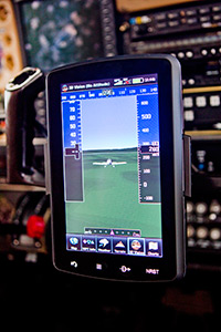
Garmin’s 3D Vision builds on the company’s pioneering synthetic vision technology (SVT) by offering a symbolic exterior view of the pilot’s own airplane as it moves over and around the surrounding terrain. The pilot can change the viewing angle if desired, but an in-trail perspective looking slightly down at the symbolic airplane (a highly realistic RV-6 with a spinning propeller) provides a view that’s easy to interpret and shows terrain in vivid detail.
Mountains, valleys, rivers, airports, and obstacles show up in color-coded clarity, and GPS-derived ground speed is displayed on the left side of the screen, altitude on the right, and magnetic heading across the top.
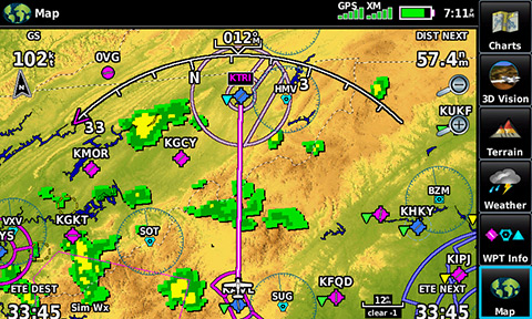
XM weather overlay
There are no “pathways” or highway-in-the-sky rectangular boxes that appear on Garmin G1000 primary flight displays. Instead, a tiny, triangular, magenta course deviation indicator at the bottom of the 796 screen shows whether the pilot is left or right of the desired course.
 Customizable icons on the "home" page.
Since the 796 isn’t connected to an onboard attitude heading reference system (AHRS), it’s incapable of providing primary flight data such as aircraft pitch attitude, indicated airspeed, or barometric altitude. Instead, it operates much as a turn coordinator does by sensing the rate of heading change and estimating the bank angle and showing the symbolic airplane in its geographic surroundings.
Like SVT, 3D Vision is especially comforting on IFR approaches when the airport appears as it would on a clear day, even when the facility itself isn’t in view through the windshield.
The 796 gives pilots the ability to customize the touch-screen keyboard in the way they prefer (qwerty or alpha-numeric). Switching between portrait and landscape views requires pressing a sequence of icons since there are no internal accelerometers as on an iPad.
The list price for a new 796 is three times as much as an iPad, and $1,100 less than the GPSMAP696—the original “MFD on your knee” that Garmin introduced in 2008 and will continue to support. (The company also lowered the price of a new 696 to $2,199.)
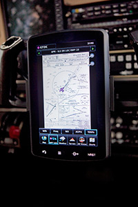 Add-on subscription to geo-referenced FliteCharts
A subscription to geo-referenced FliteCharts for the 796 is $199 a year, and a database bundle that includes all charts and navigation data is $499. Garmin’s SafeTaxi system and AOPA Airports directory are included at no additional charge.
The updated data is downloaded to the 796 via SD card.
The 796 has the same 7-inch (diagonal) screen as the 696 and identical resolution and pixel count, but a narrower, lighter frame with no external knobs or buttons. Battery life has been extended to three hours at full brightness with the XM receiver attached compared to two hours for the 696.
The 796 also offers a “scratchpad” screen that pilots can use to write clearances Magic Slate-style by dragging a fingertip. No pen, pencil, or stylus is needed or desired (although my own fat-fingered scrawling could be nearly impossible to decipher). A separate document viewer allows downloading aircraft manuals and checklists.
The 796 uses a “capacitive” screen like Garmin’s panel-mount GTN750 and 650 that sense electrical charges from the user’s finger. A “resistive” screen, such as the kind found on the aera 500 series, senses pressure instead of electrical current.
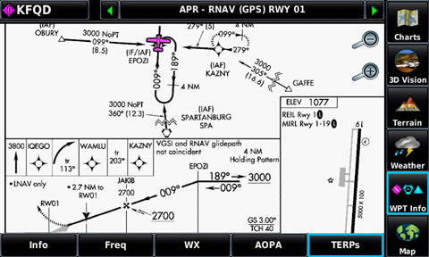
Close up of the geo-referenced FliteCharts display.
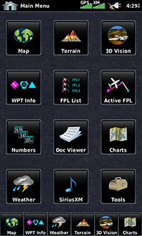
Pilots accustomed to other Garmin products will find the shallow menus with familiar icons easy to navigate. The “home” page can be reached by simply holding down the “back” key, and it’s seldom more than two touches away.
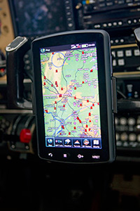 Yoke-mounted 796 showing Garmin's moving map display.
Flight plans are easy to build and modify in flight, and loading approaches becomes quick with practice. But some practice, or at least reading the 46-page Quick Reference Guide (QRG), is in order. But don’t be intimidated by the length of the QRG since much of it is lawyerly admonishments that nobody reads, and the rest is extremely well written and illustrated.
Four permanent keys at the bottom of the 796 provide the most commonly used commands: back, menu, direct-to, and nearest. There’s also a “panel” page on the moving map (familiar to users of the 496, 696, and aera series) that shows steam-gauge-style presentations for groundspeed, altitude, horizontal situation indicator, vertical speed, and turn coordinator. Unlike the 696, however, which allows users to switch instantly between the panel and full-screen map views at the touch of a single button, performing the task on a 796 requires several steps.
Airspace questions usually can be answered by touching the Class B, C, or D rings or MOA markings and reading the information provided about floors, ceilings, and radio frequencies for controlling agencies. Touch a mountain on the map and the 796 shows its height in msl.
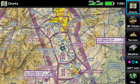
Close up showing photo-realistic sectional maps.
The 796 offers pilots their choice between Garmin’s own moving maps (with weather, terrain, and topographical overlays) and photocopied VFR sectionals and IFR low- and high-altitude charts. Personally, I prefer the clarity and better readability of Garmin’s own hybrid maps, but many pilots have been clamoring for actual charts, and the 796 gives them what they’ve been asking for. Garmin also performs a neat sleight-of-hand trick by seamlessly switching between VFR sectionals and more detailed terminal charts as the user zooms in. (Watch carefully, though, because the change is so quick it’s easy to miss.)
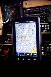 Mounted view of 796 showing sectional display.
Garmin is mum on ways that it might upgrade the 796 in the future—but the new device lays the technological foundation for ADS-B “In” features such as subscription-free cockpit weather and traffic that is at the core of the “NextGen” air traffic control system.
And 3D Vision invites speculation about ways in which the 796 might become connected to a future AHRS so that it can provide primary flight data (as Garmin’s own G3X does in the Experimental market).
The 796 is unlikely to win over 696 owners, many of whom have hard-wired the versatile MFDs into their panels. But the 796 isn’t intended so much for them. It aims squarely at the iPad by shamelessly taking some of the tablet’s best features and packaging them in a sturdy, robust frame meant solely for aviation use.
In some ways, the 796 assumes pilots already have another tablet computer or smartphone since the 796 borrows much from those devices. Also, since the 796 isn’t linked to the Internet, those other devices are still helpful for checking weather and filing flight plans remotely.
Garmin is betting that pilots, even those already enamored with the iPad, will buy a 796, too.
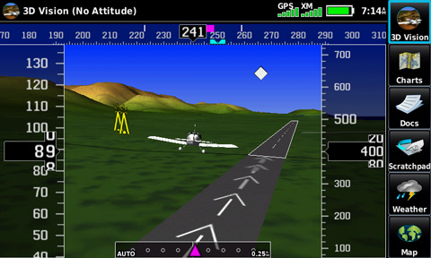
3D vision close up; when linked to a Mode S transponder the 796 will also show traffic (white diamond).

Related Articles

