Wx Watch: Radar revolution
Better Nexrad imagery is on its way
Website of the month: Get ready
So all this talk of dual-polarization radar has you champing at the bit? Well, we may not be able to use dual-pol right now but you can still get ready. For that, you’d better do some studying. Are you up to it? Is the weather-geek force strong enough with you? Then go online and take NOAA’s dual-polarization radar overview course for nonmeteorologists. It’s 42 minutes long and has tests, so it’s not exactly for the faint of meteorological heart. On the other hand, you’re bound to learn much, and I trust test results remain a secret between you and NOAA. Go ahead, I dare you to take it. —TAH
 Standard Doppler reflectivity shows some steep precipitation contouring (circled at left). But there's a question. Are the purple returns heavy rain or hail?
Let's face it: When it comes to checking the weather, most of us immediately call up imagery from one or more of the nation's 150 WSR-88D Nexrad Doppler weather radars, especially when thunderstorms threaten. Doppler radar offers a more or less intuitive picture of reflectivity returns, internal storm dynamics, and precipitation contours; it can show areas of storm rotation and potential tornadoes, and a storm cell’s speed and direction of movement. While our radar network is getting old, its technology isn’t stagnant. Science marches on, and our weather radars are receiving some dramatic improvements. Some of them will significantly boost the quality of aviation weather analysis and forecasting.
These improvements come thanks to a big upgrade in the nature of the radar beam. As we all know from ground school, weather radar works by sending out a very narrow, powerful beam of energy. This energy strikes precipitation, which returns some to the radar antenna; eventually the returns are shown on the display screen. Until now, these beams have been polarized horizontally. Think of the beam as oscillating or vibrating slightly in a horizontal direction, or think of your polarized sunglasses, which admit light in one direction only. Tilt your head, the viewing angle changes, and scenery (or the screens in your glass cockpit!) dims because the glasses weren’t optimized to receive light waves coming from any other direction.
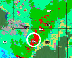 Dual-polarization hydrometeor classification shows that the same area is indeed hail (HA). BD refers to large-droplet rain, WS is wet snow, RA is light to moderate rain, and UK means there's a low confidence in the precipitation type.
Today, the WSR-88D (the “88” stands for 1988, the year the WSR-88D Radar Operations Center was established; the “D” stands for Doppler) network is being revamped to send out beams that are polarized both horizontally and vertically.
What’s the big deal about this dual polarization (“dual-pol,” to use meteorological jargon) weather radar? Horizontally polarized beams do a fairly good job of just plain seeing the width, or lateral, dimensions of some types of precipitation—rain and hail show up the best—but it’s not so reliable when it comes to differentiating between types of precipitation. That’s where the vertical component of dual-pol comes in. By being able to see both the horizontal and vertical dimensions of an airborne particle (“hydrometeor” in technical parlance) it’s possible to differentiate between a raindrop, snowflake, ice pellet, hailstone, or other type of precipitation. Where you might see a single mass of heavy precipitation on a conventional Doppler weather display, you don’t know if it contains rain, snow, or hail. With dual-pol, you can. And that’s a huge improvement.
To make these and other determinations, dual-pol Doppler provides several new products, among them:
- Melting layer detection algorithm, or MLDA. Because dual-pol can distinguish between snowflakes, wet snow, and rain, it can pinpoint the altitudes at which frozen precipitation melts to rain. Now we have a better idea of where the freezing level resides, and where icing is most likely to occur. With conventional Doppler, this mishmash of precipitation sizes and dimensions causes high reflectivity levels that often show up as “bright-banding,” a highlighted area that says, yes, there’s heavy precipitation—but gives no information as to type, no matter the radar antenna’s tilt angle.
- Correlation coefficient. This capability measures the similarities of the returns within a coverage pattern. So particles with uniform shapes (raindrops or snowflakes) show up in one signature; those with nonuniform shapes (hailstones or melting snow) are presented by another radar signature. Also, birds and insects can be better distinguished from precipitation.
- Hydrometeor classification. Based on verified dual-pol signatures, echo types within shape categories can be classified. It can tell the difference between hail, graupel (snow pellets), large-droplet rain, heavy rain, light to moderate rain, wet snow, dry snow, ice crystals, ground clutter, and biological returns (birds, bats, and insects).
- One-hour accumulation. This capability shows more accurate estimates of the past hour’s precipitation amounts.
- Storm total accumulation. This depicts storm total precipitation amounts over longer periods of time.
- It’s important to remember that while dual-pol promises a lot, it’s a bolt-on to the existing WSR-88D system. Some limitations of the original system will remain. For example, the radar beam loses strength the farther it travels from its antenna; intervening heavy precipitation can attenuate radar returns and therefore render distant, potentially dangerous returns invisible—and precipitation or other echoes below the radar beam are invisible to radar.
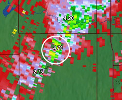 Same day, same storm, same area. Here, the dual-pol's differential phase capability further confirms the presence of hail in the circled area. A rating of 4.7 is a strong indicator of water-coated hail. Storm analysis imagery provided by Baron Services Inc.
Hold your horses
I know what’s going through your mind: “Wow, so now I can see if there’s a hail shaft buried in all that rain, right on my airplane’s datalink weather display?”
The answer, for now, is no, at least not directly.
Bob Dreisewerd, chief development officer at Baron Services Inc.—developer of the dual polarization technology for the NWS radar upgrade and the data service provider to XM WX Satellite Weather—says, “While there will be no noticeable differences in the current radar reflectivity information you are using today—preflight or in-flight—the dual-polarization information will provide the basis for even more accurate value-added in-flight weather products such as precipitation type masks for the radar reflectivity, freezing level products, storm tracks, icing products, and short-term forecasts. This data will also be the foundation for the creation of additional value-added products for aviation.”
For the time being, these products will be used by meteorologists for educational, evaluation, and operational forecasting purposes. Web access for the masses is already occurring on various websites and display software. Any in-cockpit displays of these products won’t come until there’s much more research and development. For both pilots and meteorologists, learning to use the products just mentioned will take time, practice, and discipline.
The good news is that the upgrade program is definitely under way. This can only benefit the many forecast products we use when planning a flight. Dual-pol installations began in September 2011; 35 sites had been upgraded as of February 2012, and all 160 WSR-88Ds should be completed by the end of 2013. Just thought you’d like to know.
Email the author at [email protected].
Related Articles


