Wx Watch: Briefing Timelines
Preflighting for thunderstorms, one day at a time
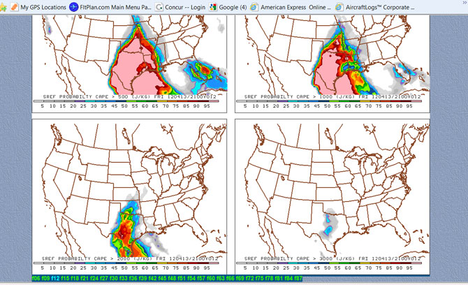
CAPE 12-hour predictions from PennState’s SREF are divided into four categories, from more than 500 joules per kilogram (J/KG) to more than 3,000 J/KG. A muggy flow from the Gulf of Mexico is predicted to create the highest probabilities over central and eastern Texas. The date stamp at the bottom of the image shows that this is for Friday, April 13, 2012, at 2100Z and is a 12-hour forecast (FRI 120413/2100V12).
Every pilot knows the rule: Avoid thunderstorms like the plague. That strategy begins with your preflight information-gathering process, which ought to extend days ahead of your planned departure. There’s a ton of helpful weather data on the Internet, and one of the best is the Aviation Digital Data Service (ADDS)—a one-stop shopping center for just about every aspect of aviation weather. I’m sure you have other favorite websites you check before ultimately receiving your official standard, abbreviated, or outlook briefing just before you take off.
Everybody has their own way of prepping for the weather aspects of each flight, but my advice is to go a little beyond the textbook recommendations. My weather briefing sequence is actually continual, and often includes daily checks of current and forecast conditions along the routes of any upcoming flights. Plus, I typically begin scoping out the weather three days before a flight. I’m not saying you should follow the same steps, but here’s what works for me. It’s a sort of weather-info countdown.
Three days before. This is when I begin checking the daily Convective Outlooks (“Wx Watch: Advance Warning,” May 2012 AOPA Pilot). These outlooks are accurate in pinpointing the future locations of both “general” and severe thunderstorms. I also look at the low-level prog charts for the days leading up to the day of the flight, to see if any fronts are forecast to move in and create any lifting needed for thunderstorms. It’s too early to check terminal aerodrome forecasts (TAFs), but it’s certainly time to begin my daily check of certain forecast models.
One is the short range ensemble forecast (SREF), which provides probability charts for ceiling and visibility, precipitation type and amount, and CAPE (convective available potential energy, which is a fair predictor of the kind of warm, moist air that’s conducive to thunderstorms). Go to Penn State’s e-Wall (www.meteo.psu.edu/rtwx/ewall/ewallsref.html) and click on CAPE to see what I mean. Be sure to check the issue times and valid dates and times so you have the latest output; they come out four times a day. Values above 2,500 joules per kilogram can indicate conditions conducive to severe storms; the higher the value, the worse the situation. Mouse over the valid times at the top and bottom of the page to see how conditions progress.
Two days before. This is the time when I recheck the SREF for CAPE, look at the low-level significant weather prognosis (“prog”) charts, and recheck the convective outlooks.
During the day I’ll call up some visible and infrared satellite views of any cloudiness or buildups and watch their progress as the day wears on. Is there a front with lots of high tops (identified by colorized or shaded highlights)? Are the storms increasing in intensity, or decreasing? Are they persisting into the night? Do the cloud patterns synch up with what the prog charts are showing? Did yesterday’s convective outlook for this day turn out to be true, or do forecasters seem more or less confident in their predictions of severe weather?
It’s not too early to begin watching Nexrad radar imagery for steep contouring of any storms, either. Are there any severe storm or tornado watches or warnings out there? This all helps in determining whether you might face a widespread area of really wicked weather—assuming the storms persist through the night or
die out past sundown and regenerate the following day.
The day before. This is a busy time, what with rechecking all the sources already mentioned, plus looking over any TAFs that fall along your route. Bear in mind that TAFs only forecast for areas within five statute miles of an airport’s runway complex, and the abbreviator “VC” only covers conditions that may occur within five to 10 statute miles from the airport. Sure, TAFs can give good pictures of wide-ranging weather features, but it’s not as simple as stringing together a series of TAFs that affect your flight. Many TAFs are spread far from each other, and a lot can fall through the cracks in this forecasting scheme. Local geographical features, for example, can cause huge differences in weather. Fog and mountain obscuration in high terrain can coexist with clear conditions at adjacent, flatter terrain, to name one.
Area forecasts can also help see into the next day. These, the TAFs, the latest convective outlooks, and the SREF guidance should do a pretty good job of identifying the most likely trouble spots.
Launch day. By this time there shouldn’t be any big surprises, but still, it’s essential to go over all the sources once more. This is to check for any strengthening or weakening trends in the forecasts and analyses.
I like to be at the computer early—say, 5 a.m. or so—and begin looking at the latest information. At the top of the list is satellite imagery. If it’s still dark you can’t see visible images, of course, but you can call up infrared views to see if there are any high tops/buildups that have persisted through the night. These may well regenerate in the heat of the day.
Next comes Nexrad imagery. Any action there? Which way are any cell tops moving? Any relevant pireps? Any areas of convection anticipated on ADDS’ Collaborative Convective Forecast Product for the next six hours? Any warnings of mesocyclonic circulations, hail, or tornadic vortex signatures (TVSs)? These aren’t available on ADDS, so try the Weather Underground’s radar views.
TAFs become very important—and more accurate—but make sure you have the newest. TAFs come out four times a day, at 0000Z, 0600Z, 1200Z, and 1800Z, so the latest early-morning TAFs may not be posted yet when you do your morning check; try later if you can, when they’re most current. And be sure to look for any amendment or correction (indicated by AMD and COR, respectively, in the TAF header). These are often tipoffs that previously unforecast conditions have cropped up—like lower-than-anticipated ceilings and visibilities, or a newly formed batch of thunderstorms. After that, it’s time for a look at any airmets and sigmets for the route, followed by winds aloft and a check of METARs and notams.
Then I print the route briefing from one of two private weather providers. This gives me something to carry into the cockpit.
By now I know if the flight will call for an instrument or visual flight rules flight plan, and have a good grip on what awaits me in the air. Oh, and there’s the go/no-go decision. Then I file the flight plan (or not, if it’s a no-go), and make a habit of contacting flight service the old-fashioned way—by telephone—for their take on the weather. But even having done all that, if I decide to launch I always get a last-minute update at the airport by checking the FBO’s weather display, calling flight service, or looking over a few aviation weather apps on my iPhone. If all looks good, it’s time to fly.
Right about now I hear some of you saying, “Hey, wait, it sounds like he gave more emphasis to Internet weather than DUATS or flight service information.” That’s true for the days preceding the day of the flight, but on the morning of launch day I always make it official by hearing out what FSS briefers have to say about the weather. That’s my final double-check on any theorizing I may have done online.
Because there’s so much information on the Internet it can be tempting to go it alone when it comes to a preflight briefing. Don’t. Let the experts make sure you have all the required information.
Besides, there’s time enough for you and me to become our own weather experts. That would be after takeoff, when we’re left to our own judgment as to how to deal with the weather. Yes, we can call flight watch (122.0 MHz) or flight service while en route, but in the end we have to live with our own decisions.
Email the author at [email protected].
Related Articles


