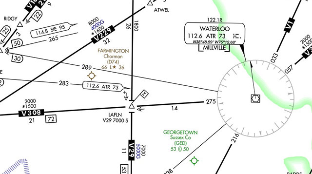
Checking the chart to see what lies ahead along the airway, you scrutinize an intersection 14 miles distant, where another airway crosses. There’s a difference in the low-altitude enroute chart’s depiction of how each airway arrives at the fix. The line representing V-308 breaks at the triangular intersection symbol, then resumes on the other side. Where V-29 approaches the intersection, its line on the chart bears a T-shaped termination on either side of the fix.
“Why?” asks the instrument flight instructor who is administering your long-overdue instrument proficiency check.
Fortunately, you did your homework for today’s review which, at your request, focuses on enroute procedures as a refresher for some planned springtime cross-countries. That preparation helps you recognize that the instructor’s query is really two questions in one.
“The t-shaped symbols on the airway indicate a change in the minimum enroute altitude, minimum obstruction clearance altitude, and/or maximum authorized altitude at locations other than navaids,” you respond, citing the explanation published on the chart’s legend. “Those symbols tell me that the change applies on V-29, not on V-308.”
Reviewing the L-34 low altitude enroute chart, you study the crossing restriction at LAFLN intersection, 14 miles west of the Waterloo VOR. It includes a notation that the crossing restriction applies on V29 southbound -- where the MEA increases to 7,000 feet between LAFLN and EZIZI.
“Does the 7,000-foot MEA apply to all aircraft?”
It’s not a trick question. Beneath the MEA, another altitude appears with a letter G as a suffix: 5000G. The AeroNav chart legend explains that this represents the MEA for GNSS RNAV aircraft. (GNSS stands for Global Navigation Satellite System, a generic term for satellite-based navigation.)
Whether flying by hand or by automation, make sure to reach crossing altitudes (or your assigned altitude) by the time the intersection is crossed. Distractions or confusion about crossing altitudes have been the source of numerous Aviation Safety Reporting System filings -- especially in hectic phases of standard instrument departures and terminal arrivals.
Approaching points where crossing altitudes take effect, be alert to a heightened risk of a wake turbulence encounter. Several ASRS reports sussed out using “crossing altitude” as a search term linked the two concerns. So listen up for altitudes assigned to nearby traffic as you approach the fix.


