Wx Watch: A slow-moving IMC-maker
Oh, no, a cutoff low!
I was taking an intensive flight training course earlier this year, and it ended up being a real workout. By this I mean instrument weather for much of the nine hours I flew during the weeklong course. Ceilings as low as 100 feet. Visibilities as low as one-quarter mile. And, yes, thunderstorms and heavy rainshowers. It’s what you might expect for the Orlando area in the spring, but rotten weather for a solid week?
Training done, I flew back home to Maryland—and another week of low, rainy weather. I was even accused of bringing the lousy weather home with me! What was going on here?
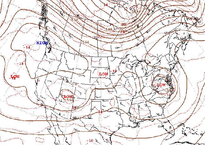
The answer: a cutoff low. Cutoff lows are low pressure centers that primarily live in the 700- to 500-millibar (about 10,000 to 18,000 feet) levels and are detached—cut off, hence the name—from any jet stream flows. You can see them on constant pressure charts, floating like islands. They live south of jet streams, and away from the steering winds that high-speed jet streams provide. For this reason, cutoff lows hang around for days at a time, causing widespread adverse weather. After a few days, they eventually move off, urged along by what little winds aloft may be present.
And that’s what happened to the Orlando/Mid-Atlantic migration of “my” cutoff low. It really did follow me home! So if you see the characteristic signature of a cutoff low in your forecast, don’t expect much in the way of good flying weather. It might be a good time to review the AIM—or even better, follow the system online as it goes through its changes and slowly makes its way out of the area.
Email [email protected].
TAF Curveball: WS
The TAF for my destination airport appeared challenging enough, with surface winds forecast out of 160 degrees at six knots (16006KT), two-mile visibility in mist (2SM BR), and a 300-foot overcast (OVC003). But it was the last entry that really caught my attention: WS005/20040KT. What sort of abbreviational curveball was this?
Translation: Wind shear at 500 feet, out of 200 degrees and 40 knots strong. Compare this with the languid surface winds and the ceiling, and you know that you could be very busy just above decision height or the minimum descent altitude. You’d still be in the clouds, on approach, and then be hit with turbulence and gusts that could rob you of airspeed and altitude at a very critical time. It’s nice to be forewarned.—TAH
Related Articles


