Wx Watch: Mixed-bag winter IMC
A low-pressure system full of surprises
December 10, 2012, presented a complex frontal system with everything from a warm front with low ceilings in snow to thunderstorms in advance of a cold front. That southward bulge in the warm front is always a sign of trouble because cold air can often “dam up” against high terrain and create lingering instrument weather.
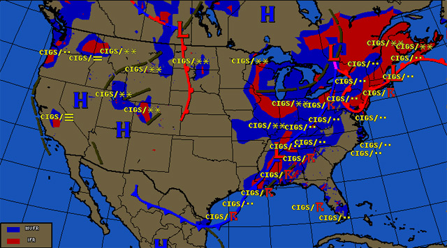
Every once in a while we’ll see remarkable-looking surface analysis charts during our preflight briefings. Sometimes we’ll see cold fronts oriented east-west instead of the usual north-south direction; a small chunk of a stationary front floating out on its own, far away from any other fronts; or maybe a small cluster of low- or high-pressure centers grouped together. Other times there are fronts bent in strange ways, as evidenced by the weather depiction chart accompanying this article. The chart is of conditions observed on December 10, 2012.
What’s going on here? It certainly seems like there’s a lot happening, and there’s a lot of lousy weather over most of the northeastern United States. Why?
First, let’s identify all the players in the Northeast that day. The main actor is a fairly deep low pressure center in southeast Quebec and northeast Ontario. How deep is “deep”? The center of low pressure registered 998 millibars, or about 29.41 inches of mercury. We’ve had hurricanes with higher pressure, folks!
So it should come as no surprise that the pressure gradient around this low is as steep as the low is deep. The isobars—lines connecting points having equal pressure values—were especially tight on the north side of the low, so surface winds were very strong there. Because of the circulation around low pressure, those winds were out of the east and northeast, transporting cold, maritime air inland. Cold, damp air forced into low pressure means plenty of condensation, low clouds, rain, drizzle—and in this case snow, which fell in northern Maine.
Airports all over the Northeast offered plenty of low IMC—defined as ceilings below 500 feet agl and/or visibilities below one statute mile. White Plains, New York, saw conditions of one-quarter-mile visibility in fog with a vertical visibility of 200 feet. Bedford, Massachusetts, had one-quarter-mile visibility and a 200-foot ceiling.
But what about that southward kink in the warm front, the one that dives down to the Mid-Atlantic? To some degree this shows the effects of surface friction on the slow-moving warm front as it passes over the eastern Appalachians. If the bulge extends the length of the Appalachians, another way to look at it is to think of the front as following the lower-level contours of higher terrain. The front also reflects a leftover low layer of comparatively cool air ahead of the warm front, hugging the surface from the previous days. In the early morning, low IMC was the rule east of the Appalachians, and as the day wore on ceilings lifted in this region—but conditions in the Northeast remained rotten.
What created this mess in the first place? An area on the east side of a trough in the upper atmosphere, where lifting forces typically prevail. Air rising aloft means air at the surface must converge, and when winds converge at the surface there’s no place else to go but up.
In the colder regions of this frontal complex, clouds are most likely layered and ice-laden. But ahead of the cold front in western Pennsylvania we see thunderstorms. So it’s a little bit of everything—and a fairly common situation in the fall and spring months. Anyone planning a flight in the Northeast on a day like this better be instrument-current, have datalink or airborne weather radar (and know how to use and interpret both), and be flying an airplane that has certified flight-into-known-ice (FIKI) equipment—and plenty of fuel. With a destination in New England you may fly a long way before reaching a suitable alternate airport. This makes already-tense missed approaches even more tense. Better to have a couple hours of reserve fuel than the legal, 45-minute minimum on days like these.
Email [email protected].


