Flying Carpet: Good Omen?

www.GregBrownFlyingCarpet.com
“Not a good omen so early in the morning,” I muttered, to Jean’s chagrin. This was my second attempt to deliver her and her mother to visit relatives in Montrose, Colorado. Last year an unforecast and unreported 100-mile squall line turned us back mid-route, forcing my passengers to drive eight hours instead. It turns out that blank cockpit-weather displays don’t necessarily mean storm-free skies—a huge weather radar gap spans the Four Corners region, and not even Flight Service knows what’s there. At least this year I knew weather avoidance would be strictly out the windshield for part of the trip, valuable planning knowledge where usable airports are hundreds of miles apart.
That assumed we could depart in the first place. Despite forecast clear skies, the north-south line of thunderstorms entirely blocked our northeasterly route, and daytime heating threatened further development. Could we safely circumvent the fast-growing line before it engulfed our airport? And if we could, what hazards might lurk in the weather-radar gap beyond?
 It’s always best to address piloting challenges one at a time. Beyond the thunderstorms, Winslow and Holbrook offered clear skies within weather radar coverage. With safe landing options on both sides of the weather, I’d focus for the moment on departure.
Bypassing the thunderstorms to the north would be most direct, but would take us near the 12,000-foot San Francisco Peaks. Although there currently appeared room for safe passage, what if the weather blossomed closer to the mountains?
To the south was lower terrain, but the line extended farther in that direction and appeared to be expanding. What’s more, we’d be steering away from our destination, and if the weather enveloped Flagstaff we might be blocked from returning home. There were numerous fair-weather airports to the south and west, however, meaning the only risk was getting stuck somewhere we didn’t want to go. That, I could live with.
Clearly north was preferable if we could safely bypass the weather, and south offered a safe, if uncertain, alternative. So when radioing for takeoff I requested the option to depart in either direction, based on a better look from aloft. Even before reaching pattern altitude, it became obvious that thunderstorms hugged the mountains too closely for safe passage in that direction.
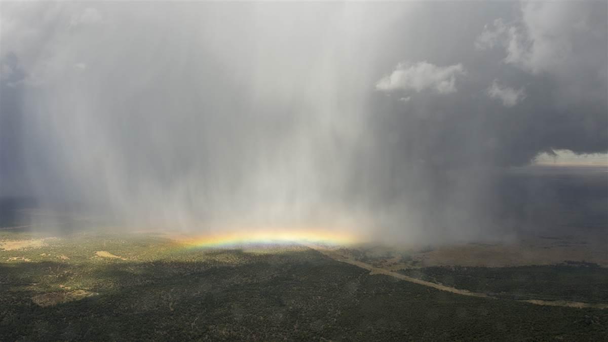
“Good choice,” said the tower controller when I elected to fly south. Spellbound, we ogled the row of femmes fatales sparkling and dancing off our wing. Thunderstorms offer mesmerizing beauty from a distance, but great danger close up. Ten miles south we reached the line’s end. We’d just turned toward friendlier skies beckoning from the other side, when the last of the towering sirens unveiled a dazzling ground-hugging rainbow (left). We resisted temptation to approach for a closer look.
“A rainbow’s a good omen, right?” said Jean. So I hoped, but having dodged thunderstorms so soon after takeoff with two flight hours to go, that remained to be seen.
Related Articles


