Closer look
Shapes of dangerous returns
What's lurking out there can be seen by airborne weather radar
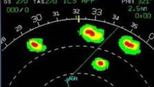 Easy path
This weather radar view depicts scattered cells with circular shapes and small cores of high-reflectivity returns. Assuming they don't grow, the courseline suggests an easy circumnavigation.
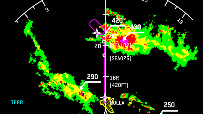
 Hidden weather
That black area behind the thin line of red, high-reflectivity returns looks like a precipitation-free zone, but it's a radar shadow that conceals the worst weather. Radar energy from the antenna is being absorbed by the heavy rain in the red returns. This blocks the radar's view. A DC–9 crew was fooled into flying through to the "clear" area, and a fatal crash ensued.
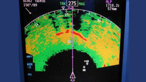
Hooks and steep gradients
Projections from a cell's central mass, especially curved ones, can indicate tornados. Steep precipitation gradients—those with little space between green, yellow, and red returns—are other signs of intense activity. Hold in that top cell? No way!
You may have heard some pilots boast “I’ve got radar,” with a certain air of invincibility. True, having airborne weather radar can be a real help in detecting and staying clear of thunderstorms. But there’s a lot to learn about using weather radar, and not knowing how it works can put you in harm’s way.
Radar is an acronym for “radio detection and ranging,” which says a lot about how thunderstorm echoes appear on an airplane’s display screen. The radar’s transmitter projects microwave energy—think of it as noise, measured in decibels—from an antenna dish, mounted in the airplane’s nose (on large airplanes) or in a pod on a wing (with smaller airplanes). This beam of energy travels forward until it encounters water droplets, then reflects back to the antenna and is ultimately resolved into imagery on a cockpit display screen.
The strength of the reflected returns—echoes—depends on several things. One is the power of the transmitter. Another is the size of the antenna. The more powerful the transmitter, and the bigger the antenna, the better—and farther away—the radar can detect precipitation. That’s because the radar puts out a strong, narrow beam, like a spotlight.
The nature of the precipitation ahead is also important. Snow and the small, fine droplets in drizzle or nonconvective clouds don’t reflect very well, so they don’t tend to show up on radar. But the larger the droplet size or rainfall rate, the better the reflectivity—meaning more “noise” ricocheting back to the antenna. Hail, especially wet hail, has the highest reflectivity.
Algorithms in the radar receiver translate the strength level of the radar returns into decibel levels, then into the color displays familiar to us all. Light green stands for light precipitation, yellow for stronger rainfall rates, then red and purple for the most dangerous levels.
Airborne weather radar is great because it can show the shapes of dangerous returns—such as the hook shapes made by tornados, or the curved bands of precipitation that signal bow echoes. Radar also can show you where to steer to avoid precipitation. A display screen filled wall-to-wall with yellows and reds is a strong hint to make a 180-degree turn.
Another advantage is that the returns from airborne weather radar occur in real time, unlike the potentially dangerous time lags of datalink weather radar imagery. Datalink imagery from FIS-B—part of Automatic Dependent Surveillance-Broadcast (ADS-B)—or satellite weather sources can be several critical minutes old by the time it makes it to the cockpit. A five-minute delay may not seem like much, but a thunderstorm can grow or move significantly in that short time.
A big downside of airborne weather radar is its comparatively weak signal. The signal generated by a small, approximately 12-inch-diameter antenna of the sort used in many smaller general aviation airplanes is less like a spotlight and more like a dim porch light.
Weaker signals can be absorbed or scattered—attenuated, to use the official term—by a dense area of precipitation. As a result, the radar beam can’t penetrate deep into a storm’s structure. What looks like a narrow band of precipitation may really mask a monster thunderstorm’s most dangerous areas. Weak signals also limit the radar’s effective range. The maximum effective range of most general aviation airborne radars is about 40 to 60 nautical miles.
Airliners, with their 30-plus-inch-diameter antennas, can easily examine thunderstorms and precipitation more than 100 nm away.
Here’s where datalink weather radar imagery is superior. Because the signals are received from a powerful, ground-based network of weather radars, there’s no attenuation, and their effective ranges are far greater.
Another caveat of using airborne weather radar involves interpretive skills. To use radar effectively, you have to know how to manage the antenna’s tilt and range settings. For example, you need to regularly tilt the antenna—yes, the radar display has tilt and range controls—to determine the best angles for examining the shapes of thunderstorms. To learn this, you’ll need to attend a course on operating and interpreting weather radars.
As always, the best tactic is to avoid thunderstorms by wide margins. Radar can help, but staying visual will always be the gold standard.

