Mixing and matching disaster response assets
Manned and unmanned aircraft each have a role
Another season of devastating storms has demonstrated that both manned and unmanned aircraft play key roles supporting first responders.

In 2018, following Hurricane Florence in North Carolina, I spent a week flying relief supplies into Wilmington in very dynamic airspace with limited air traffic control and no radar services in the earliest days. The combination of unmanned aircraft, helicopters, single- and multiengine aircraft, and jets made for some of the most unique and sometimes hair-raising flying I've ever done. But did we really need all those different types of aircraft fighting for their piece of the sky, or did they all have a special role to play? It was a question I thought about a lot on my return flights to reload.
Hurricanes Florence and Michael caused widespread damage and disruption, and responders benefited from imagery collected as soon as the skies became flyable again. That imagery informed decisions by companies and governments allocating resources to assist people in trouble. Knowing where the worst of the trouble was helped save lives and accelerate restoration of services.
As recent events demonstrated, all types of aerial imaging are useful. Unmanned aircraft provided highly detailed images, including 360-degree panoramic views from key locations that were integrated with image maps produced by the Center for Robot-Assisted Search and Rescue, and Florida State University personnel who flew in Mexico Beach, Florida, after Michael wreaked havoc on the panhandle region. Combining those image assets with layers of mapping data simplified assessment. The CRASAR/FSU team noted in social media posts that manned and unmanned flights were, in some cases, coordinated at the local level using radios and other tools for situational awareness. (A reminder for those who are not part of an official, public safety response: keep your drones on the ground.)
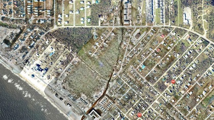
The FAA has also recognized the value of unmanned aircraft in disaster response in recent years, warning hobbyists and non-official users away while facilitating the use of all available technologies including drones. The 2017 response to Hurricane Harvey in Texas became a model in many ways for future efforts, demonstrating that airspace can be shared safely. Rapid granting of authorization afforded unmanned and manned assets to assess damage to key infrastructure such as fuel tanks, power lines, and other critical components of the power grid. Rapid assessment helped speed the initial response, and the transition to the long-term recovery effort.
Following Harvey, the FAA set about making advancements in how quickly agency personnel could approve emergency UAS operations. In my experience, an emergency authorization now takes about five minutes to obtain. Using the FAA System Operations Center for emergency drone waivers has been very professional. I have nothing but praise for them.
So, the question is no longer if drones can provide valuable feedback in disasters, but when, and the biggest remaining obstacle to realizing the full potential of this aerial tool is figuring out how to deliver imagery to the right people at the right time to support effective decision making. From the front lines I can tell you that is an ongoing challenge.
Essentially what we have today is a fractured incident command process. In emergency situations and large disasters there is enough chaos churning that gaining good information rapidly and getting it to the right people is nearly always a challenge.
EagleView, one of the more experienced operators in this space, has a fleet of 120 manned aircraft (primarily Piper Senecas and Cessna 172s) that can deploy rapidly just about anywhere in the country. Their customers include insurance companies, construction companies, utility companies, and government emergency management agencies. Each customer has different needs from the images captured, but EagleView delivers all imagery in a format that enables users to decide what layers of information they want and need.
EagleView can also muster unmanned aircraft pilots through a partnership with PrecisionHawk’s Droners.io network. (AOPA recently forged its own relationship with PrecisionHawk and Droners.io.)
EagleView has found that combining both manned and unmanned aircraft offers the best perspective and the most useful data. They put a lot of planning and effort into coordinating those assets to eliminate as much of the chaos as possible.
EagleView stages pilots and equipment as much as a week in advance when forecasters warn of an approaching major storm, and uses a centralized control center to dispatch those assets. By using a centralized operations center, adjustments can be made on the fly to respond to dynamic situations. EagleView's manned and unmanned pilots don't communicate directly with each other. All communications are routed through the central command center and efficient tasking is then delivered to those who can meet the imaging need at hand. Images from all aviation assets are sent back to EagleView for rapid processing and distribution to their government and nongovernment customers.
“We use manned aircraft when wide-area capture needs to be done. We've got a capture platform that gives us a pretty high resolution approaching what we can obtain from drones,” said EagleView Chief Operating Officer Jay Martin, in a telephone interview. “We can cover vast swaths of territory.”
Manned aircraft lead the way capturing images of wide areas that are then combined with satellite images, and machine learning is employed to analyze the data. Once EagleView has the outlines of the big picture, drone crews are dispatched for a more detailed assessment of key locations.
“We deploy the drones into areas that potentially are either on the outskirts of the area of interest, or when there is very significant damage we know our customer will want close-ups of or areas where machine learning indicates there is likely damage,” Martin said.
The EagleView solution that makes logical sense is its multimodal approach using the different platforms. Martin says that is what helps EagleView deliver the "imagery and data that is going to help people make the best decisions regardless of where that imagery came from."
My experience in public safety flying tells me what is lacking is that wider-area perspective, and a coordinated approach in large disaster situations. When entities are most concerned about just their town or the entire state as a whole, situational awareness of that big picture can be lost.
Hopefully, there will come a time when manned and unmanned aviation assets can be pooled, coordinated, and dispatched on a statewide or regional basis to provide rapid and actionable data. Until then, it is just going to be a less effective and disjointed process.
Related Articles


