No place for drones
Unmanned aircraft sidelined in initial Florence response
As the former Hurricane Florence weakened to a tropical depression and the ceilings gradually lifted along the battered Carolinas coastline, drones remained largely grounded while most other tools in the disaster response toolkit, including manned aircraft, saw heavy use.

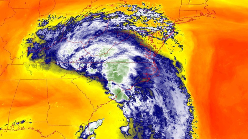
As swift water rescue teams and U.S. Coast Guard personnel joined a massive response by local, state, and federal agencies to the widespread flooding caused by Florence, it became increasingly clear that the Sept. 14 landfall, often a hurricane’s final act, was only the beginning of an inexorable, slow-moving, and far-reaching disaster that could prolong the initial phase of the response, search and rescue, by a week or more. Rainfall records were shattered as 18 trillion gallons of rain, by one estimate, fell on the region—enough water to fill Chesapeake Bay, or cover the state of Texas four inches deep.
“In situations like this where you’re concerned about a wider area, a drone isn’t necessarily the right tool to use,” Rhode said.
The FAA sought to discourage would-be drone enthusiasts from filling the airspace with unauthorized aircraft, which have been known to disrupt emergency responses to wildfires and other disasters. The agency posted on Sept. 14 a special notice restricting drone operations in support of the official hurricane response to 200 feet agl across North and South Carolina, reminding unmanned aircraft operators that drones must always give way to manned aircraft.
U.S. Coast Guard helicopter crews had rescued 57 people from rising waters across North Carolina by Sept. 15, and the FAA warned drone pilots that the agency was prepared to levy stiff fines, potentially exceeding $20,000, against any drone operators who interfere with the emergency response. North Carolina Gov. Roy Cooper added his voice to an official chorus pleading with drone owners to stay out of the way.
IFR conditions persisted across much of North Carolina and Virginia as the sun rose on Sept. 17, though clouds were lifting at last across much of the region devastated by the slow-moving storm that had claimed at least 16 lives, most lost to rising water, falling trees, and related road hazards. The storm “has never been more dangerous than it is right now,” Cooper said at a Sept. 16 news conference. While the rain was expected to end by Sept. 18, many rivers were forecast to continue rising for days to come, and rescue workers including volunteers and Coast Guard personnel plied flooded streets in small boats, plucking stranded residents and their pets from homes. All of North Carolina’s 100 counties had National Weather Service warnings posted for current or anticipated flooding in the days to come.
While the long-lingering remnants of Florence drew comparisons by meteorologists to the 2017 visit of Hurricane Harvey on Houston, the role of drones in the initial response and rescue phase appeared to be much more limited than it was in 2017, when drones and manned aircraft shared the skies in a carefully coordinated effort to gather images and data, documenting rising waters and compromised infrastructure. It remained to be seen how quickly the dozens of drone pilots who staged to respond would be pressed into action, and most of these were called up by utility companies and insurers, not the agencies involved in rescue and initial response.
Veterans of those 2017 storm responses working with the Center for Robot-Assisted Search and Rescue (CRASAR) said they had offered their services to state and federal agencies but had yet to be summoned by any emergency management officials, as they had in the wake of many previous storms and other disasters.
By Sept. 17, relatively few images and video clips taken by drones had made their way into the public domain, apart from a short aerial tour of the flooding in New Bern, North Carolina, posted by The Washington Post on YouTube. CRASAR officials had participated in various conference calls with the Federal Emergency Management Agency in the days before and after the storm’s arrival and reported there was little talk of using drones during rescue operations.
One possible explanation for the lukewarm response by emergency responders is that unmanned aircraft have yet to prove they can deliver timely, actionable intelligence to incident commanders during the initial phases of a widespread emergency that compromises cellular and other communication networks. Gigabytes of data from flying cameras must often be relayed by hand on memory cards from the field to an emergency operations center, and by the time the data is analyzed and delivered, a process that takes hours at best and days in practice, the situation has changed.

Rhode said that in contrast, he can capture images with his cellphone of sufficient quality to support a basic assessment and enhance situational awareness, then find and circle a working cell tower to transmit the images to emergency operations centers straight from his phone in near real time. Those images allow responders to set priorities, and flag specific locations and infrastructure for more detailed inspection if needed.
Rhode said another factor limiting the efficacy of unmanned aircraft is the huge scope and scale of responses to major events, which require coordination of efforts among disparate agencies. Incident commanders are still learning what drones can and can't do, Rhode said, noting that he has personally been asked to push the limits of current regulations and laws during an emergency response operation involving multiple agencies.
“I get more concerned about command decisions that are made about what they think drones can do, versus what they can really do,” Rhode said, noting that the line-of-sight limitation is a significant factor when it comes to a wide-area response. “All that stuff is beyond line of sight. New drone pilots…that really want to please command and give them what they’re asking for, and just get themselves into trouble.”
Incident commanders and drone pilots alike still have relatively little experience coordinating the efforts of drone teams along with all of the other assets in the field, and that creates more opportunities for trouble. Ironically, Rhode planned to teach a class on just that topic, advanced unmanned flight operations in a multi-agency response, on Sept. 21 and 22, a training geared for North Carolina first responders that was planned long before Florence appeared on any satellite images.
As the chief pilot for the Wake Forest Fire Department prepared to launch his Cessna 182, rather than his quadcopter, Rhode said the time for drones would come later, perhaps much later.
“The biggest message from drone point of view is, don’t become part of the problem,” Rhode said. “Don’t feel like you urgently need to fly.”