Instrument Tip: The lesser-knowns
Can you identify these chart symbols?
You study them in training and stare at them on every flight. Yet chances are there are more than a few symbols you don’t understand.
Aeronautical charts have a wealth of information—if you know what to look for. We’re going to assume you have the basics of the instrument low altitude en route charts covered, so here are five symbols you may not know.
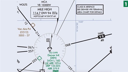 Minimum crossing or turning altitude. When a waypoint or navaid has a flag with an X inside, it indicates there is an associated minimum crossing or turning altitude at that point. The Denver area low altitude chart has many examples of this in a small area. For each one you’ll find the relevant airway number, the altitude, and direction of travel. For example, if you’re crossing the Mile High VOR on V8 you must be at least 10,300 feet when traveling westbound.
 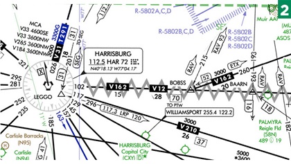 Unusable airway segment. Occasionally a Victor airway is established and later marked as unusable. If this happens you’ll still see the airway, but it will be covered with what looks very much like someone at the charting office took a marker and squiggled on it. Victor 12 between the Harrisburg VOR and the BOYER intersection is a good example. If you’re navigating by GPS you can still file and accept a route between the two waypoints, but VOR navigation is prohibited along the airway. Often these routes are unusable because of signal problems with the VOR, and reading the chart supplement you learn the Harrisburg VOR is unusable beyond 10 miles between the 097- and 107-degree radials, exactly where you’ll find Victor 12.
 Oceanic routes. Look to the Florida coast and you can see large, solid brown and black lines extending out into the ocean, each with an associated number. AR stands for Atlantic route, and BR for Bahamas route. On the Pacific side you can find A, R, B, and G routes, each a variation on one-way air traffic routes. These are not unlike normal Victor airways, except that they may require specialized radios to receive the signals.
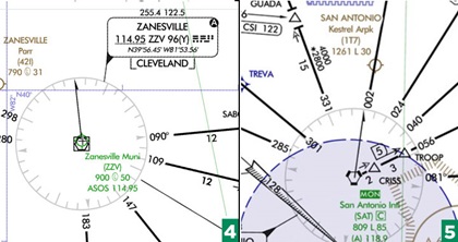
- Automated weather broadcast service. Some VORs offer the option to receive automated weather broadcasts. Look for the small, reversed A in the upper right corner of the navaid’s information box, like the one in Zanesville, Ohio. This feature makes it easy to pick up the automated weather from an AWOS or ASOS station without switching communication frequencies.
 Minimum operational network. Let’s say your GPS goes out because of a national emergency, or more likely, an equipment failure. What do you do? Knowing that decommissioning VORs will reduce the level of service, the FAA established a Minimum Operational Network that ensures pilots will be able to navigate virtually nationwide above 5,000 feet. Above the airport ID tag look for MON in reversed text. It’s a quick and easy way to establish an airport that still has an instrument approach that doesn’t rely on GPS. So, if GPS fails for any reason, you can navigate above 5,000 feet to one of these airports and shoot an approach.

Ian J. Twombly
Former Editor Ian J. Twombly is a professor of aviation at the Community College of Baltimore County and the owner of a Piper J–3 Cub.
Related Articles


