Help me!
Using in-flight weather resources

Cameras, sophisticated multimillion-dollar radar. But once you launch, the story is completely different. Up there, where it matters, the resources thin out considerably, and constitute essentially four main avenues of information.
Mk-1 eyeballs
There is nothing more reliable or more immediate than what you see out the window. What you can observe at that moment is ultimately the best source of information, and the most important. In fact, the eyes are so important that pilots have created a funny type designator that speaks to their prowess as a tool: the Mk-1 (Mark 1) eyeball.
Humans are sight creatures, so it makes sense that our best resource is our own eyes. But seeing in-flight weather isn’t necessarily the problem—interpreting it is. Here, unfortunately the only way to improve is to practice. Generally that means flying more, but also being more deliberate about increasing your weather knowledge as you fly. Level off below cloud layers or the bottoms of more widely scattered clouds and estimate the bases. Then go find out if you’re right. Do the same above layers. Level off, estimate their distance below you, and go find out if you’re right. And if it’s a beautiful day and there’s some distance between the nice puffies, estimate how far away they are and use your groundspeed to estimate how long they’ll take to reach. Do this exercise a few times and you’ll rapidly become adept at estimating your distance from the clouds, which is a critical skill with any sort of long-distance VFR flying.
Eyeballs are also great for picking out hazards such as rain and snow (a misty blanket coming down from the clouds), potential convective activity (deep white or gray towering cumulus), and wind (waves of grain, ripples in water, smoke). Take the time to catalog these hazards in your experience bank so you can better see and predict them in the future.
Air traffic control
Although not primarily responsible for keeping airplanes away from weather, air traffic control does have a few tools available that can help. Plus, if you’re already receiving flight following, reaching out to controllers is quick and convenient.
There is nothing more reliable or more immediate than what you see out the window. What you can observe at that moment is ultimately the best source of information, and the most important.The same radar scope a controller uses to direct aircraft also displays some types of weather. Critically, ATC radar doesn’t show clouds, so controllers can’t keep you from flying VFR where you shouldn’t be. But their scopes do show precipitation, with some caveats. First, their radar doesn’t differentiate between snow, rain, or ice. Neither can the radar tell if it’s just dense clouds or stuff that’s falling to the ground. And capabilities vary across facilities. An approach facility operated by the military (many Class C areas) may not have the same equipment as one operated by the FAA, and center and approach differ as well.
 shows a rudimentary radar overlay. With this information a controller can advise pilots of areas of light, moderate, heavy, or extreme precipitation far enough in advance to plan a reroute.")
 The bottom line is that the information is good, but temper your expectations. What you can pretty reliably receive is intensity levels of precipitation. Normally pilots on instrument flight plans request the information because it gives them a sense for whether or not it’s safe to fly through the precipitation, whereas most VFR pilots are looking to avoid it. But these precip reports are a handy tool to help determine if the weather is convective, and the movement. Maybe most important, you can plan reroutes far in advance of any isolated weather because ATC can advise 30 miles or more in front of your path the general location of the precipitation. And that obviously gives you a big area to avoid.
Flight service
The same folks you call on the ground prior to taking off are also available in flight. You can reach a flight service specialist in the air by calling the frequency listed on the nearest VOR spec box on the chart, or if a remote communication outlet is available, directly on that frequency. The FAA’s Aeronautical Information Manual has the details of how to find these and how to phrase your call to make it easier for the specialist to find you and answer.
You can plan reroutes far in advance of any isolated weather because ATC can advise 30 miles or more in front of your path the general location of the precipitation. And that obviously gives you a big area to avoid.For things like exact storm location, air traffic control is a better resource. But for other information, flight service can be a great resource. And the best part is that you can take your time and gather as much information as you need. Asking about the weather report in multiple places isn’t really appropriate on an ATC frequency, but with flight service you can query the weather at your destination and possible diversion points. You can also get information about conditions en route, such as airmets and sigmets. The specialists will help review notices to air missions (notams), give you forecasts, pilot weather reports (pireps), and pretty much anything else that’s easy to grab on the ground, but sometimes hard to find in the air. Think of them sort of like your airborne Wi-Fi that can search through the aviation weather pages. And make sure to return the favor and file a pirep while you’re on with them (see “Pireps Please” above).
EFB applications and in-flight weather
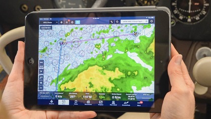 Tablets and electronic flight bag applications are the best things to happen to aviation since GPS. For a few hundred bucks anyone can now have a basic GPS with incredible flight planning capabilities. But more importantly, we now have reasonably priced in-cockpit weather. In the pre-tablet era you needed a dedicated panel-mounted multifunction display or airborne weather radar to get such information, both running tens of thousands of dollars. Now we can have the same tools for a fraction of the cost, and we’re all flying safer as a result.
Most pilots fly with one of two weather sources, although some choose to use both. ADS-B weather is subscription-free. Buy an iPad, subscribe to an application such as ForeFlight or Garmin Pilot, buy a $100 receiver, and you can have datalinked radar and more than a dozen other weather products in your cockpit. The downside is that ADS-B weather is a carrot intended to get pilots to equip with transmitters, so the radar resolution isn’t as good as it could be, and the information is sent by ground stations, so you have to be high enough to receive the signal. In most parts of the country that’s only a few hundred feet off the ground, but there are coverage gaps in the mountains.
SiriusXM Aviation is a commercial provider of in-flight aviation weather. For mobile applications you’ll need a buy a slightly pricier receiver and pay for a monthly subscription. But the quality is unquestionably better than ADS-B, and since SiriusXM is satellite based, it’s available starting on the ground, and it’s nationwide.
Regardless of which provider you choose, it’s not something you can turn on one day and start scud running or dodging thunderstorms. There’s a learning curve to understanding what the technology is telling you and what the various capabilities and limitations are. Especially as you progress toward instrument flying, understanding things like the fact that the radar can be more than 12 minutes old is critical. And that green doesn’t always mean go, just as yellow doesn’t always mean avoid.
Despite the caveats, having this information in flight represents a massive safety benefit, and makes flying much more fun and efficient.
In fact, the information is so good, and the capabilities so vast, that we sometimes forget we have other tools available. Our eyes are still our most important asset, and ATC and flight service are invaluable tools as well. Taken together, all these sources of in-flight weather can provide lots of information that is fun to learn to use, and even better to put into regular practice.