Weather cameras
Now in the Lower 48
By Mike Vivion
One of the challenges that all aviators face frequently is trying to visualize the actual weather, based on the various weather reporting and forecasting products we have available to us.

Wouldn’t it be nice if we could just look at a photograph of that weather? It turns out that you can—at least in some places. An increasing number of places.
The FAA has installed and operated an extensive system of weather cameras in Alaska for several years. That system is now being expanded to the Lower 48, in Montana and Colorado initially. Hopefully, more states will be added soon.
The FAA Weather Camera system has its roots in a small system of cameras set up at three airports in central Alaska by a graduate student (and Army aviator) named Jim Buckingham. I flew regularly in that part of Alaska at the time, and I was impressed both with the utility of the cameras, and with how quickly the air taxi pilots in the area adopted the cameras as a vital part of their weather planning.
Those early weather cameras were primitive by the standard of today’s camera systems, but they got the job done, both as an experiment and as an integral part of Buckingham’s doctoral degree program at the University of Alaska Fairbanks. After these camera systems were in use for a couple seasons, the FAA took over the original sites and began to expand and improve on the system with funding earmarked for the project by Alaska’s senior senator, Ted Stevens. Thus was born a system that now numbers 230 weather cameras in Alaska.
More recently, the states of Montana and Colorado have cameras sites operational, and Hawaii and Mississippi are also adopting this system. Many of these camera systems located in the Mountain West will be installed in or near mountain passes, to provide near real time visualization of the current weather in these remote areas. Additional cameras are being installed at some mountain airports, to provide another view of the actual weather to supplement automated weather observers. At present, a total of 14 camera installations are operational in Colorado, and four sites are operating in Montana.
Having used weather cameras frequently in interior Alaska during the early years of the weather camera program there, I became enthusiastic about the utility these systems provide. Since moving to the Lower 48, during my regular Oshkosh visits, I’ve regularly suggested to the FAA’s technology types there how valuable these camera systems could be in the Lower 48 states. So, let’s take a look at a weather camera site near my home, to understand the kind of information these sites can provide to a pilot on a cross country flight.
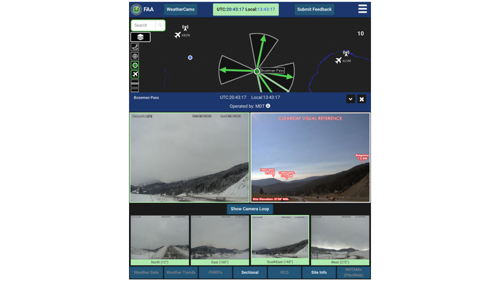
The image above is a screenshot taken from the camera site on Bozeman Pass, just east of Bozeman, Montana. The pass tops out at higher than 6,000 feet msl, with valleys at about 4,500 feet on either end. The general map can display several different backgrounds, including a sectional chart if desired. Once a camera site is selected from the main map, the camera views and images for the selected camera are displayed.
The superimposed window displays the camera images themselves. Each current image is positioned next to a “Clear Day Image” of the same camera angle to provide perspective to the user. The clear day images are often annotated with distance and elevation of notable landmarks in that image to better facilitate assessment of visibility and ceilings. The system will also play a loop of recent images from that camera by pressing the “Show Camera Loop” button. The other camera angles at the selected site are shown at the bottom of this window. Clicking on one of those images changes the primary view to that camera’s view.
Camera images are updated every 10 minutes. Wondering what utility these systems might provide at an airport with an ASOS/AWOS? Consider that a METAR is valid for up to an hour, and a lot can change in an hour. When installed at an airport, one of the cameras is often set up to provide a view of a windsock as well. In between airports, mountain pass weather can be difficult to assess without literally going there to “take a look,” and many a pilot has run into difficulty participating in that exercise.
Montana Aeronautics in cooperation with FAA is expanding the system within the state, as is Colorado. The FAA Alaskan Region will be exploring the use of the new Starlink satellite system to support two remote systems in Montana to provide internet service in remote sites where there is no internet connectivity. If the Starlink system pans out, it may be a viable avenue to providing weather cameras in some of the remotest parts of the country, at a reasonable monthly cost for unlimited data.
If you have a few minutes, go to weathercams.faa.gov and look around at our part of the world and explore this innovative system. It’s also fun to explore Alaska remotely using these systems.
More important, if you’re going to be flying in Montana or Colorado soon, utilize these systems. I think you’ll find them to be very helpful, and a great resource to foster aviation safety.
As a footnote, after I wrote the first draft of this article, I was returning home, planning to fly through Bozeman Pass. While about 40 miles out, I looked at the pass weather camera site with my cellphone and found that blowing snow was obscuring the pass. So, I diverted toward the north end of the Bridger Mountains, where visibility was far better. As a former user of the Alaska systems, I am excited to welcome these important systems to the Lower 48.
Mike Vivion, of Bozeman, Montana, is a commercial pilot and Gold Seal flight instructor with more than 13,000 hours.
Related Articles


