Making the grad(ient)
New climb/descent tables from the FAA
By Bruce Williams
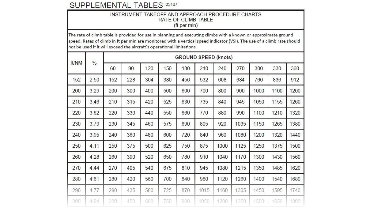
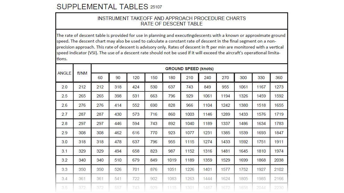
In April 2025, the FAA began publishing new rate of climb and descent tables in the terminal procedures publication (TPP), the books of instrument procedures.


No, the feds didn’t discover new laws of trigonometry. Instead, the two new tables, which appear on pages J2 and J3 in the legend section of the TPP, split information that has been crammed into one table that formerly appeared on the inside back cover.
The first table, optimized for takeoffs and for climbs, correlates climb gradients in feet per nautical mile with climb rates in feet per minute, based on your groundspeed. The table notes helpfully remind you that we monitor rate of climb on the vertical speed indicator. The second table is a reference to be used primarily during descents. It shows descent angles in degrees and the corresponding gradient in feet per nautical mile and rate of descent in feet per minute, again based on your groundspeed. (ForeFlight can display your climb or descent gradient in feet per nautical mile in one of the customizable data fields that you can show at the bottom of map screen. See “Sipping Information from the Right Glass,” November 2023 AOPA Pilot.)
As the Instrument Procedures Handbook, the Aeronautical Information Manual, and other sources note, unless obstacles intrude along a departure path, the standard IFR climb gradient of 200 feet per nautical mile, which corresponds to a climb rate of 300 feet per minute at 90 knots, keeps you clear of terrain and obstacles. Likewise, if you fly to runways with clear approach paths, a standard 3-degree glideslope or glidepath provides a smooth, stable descent, which according to the table requires a descent rate of 478 feet per minute at a groundspeed of 90 knots.
Even if you fly in the flatlands, reviewing these tables is an essential part of preflight planning, because many IFR departures and missed approach segments require more robust climbs. Often, approaches include glidepaths or stepdown segments that require a downhill tilt of more than 3 degrees.
Consider the approaches to Runways 14 and 32 at Rogue Valley International–Medford Airport (MFR) in Oregon. The profile view for the ILS or localizer to Runway 14 shows a standard 3-degree glideslope from the final approach fix at OSSAJ, but the minimums section includes two decision altitudes for the straight-in full ILS. The first line specifies a 200-foot decision altitude and one-half statute mile visibility, standard for a Category 1 ILS. That decision altitude is tagged with a #, however, and that symbol directs you to a note in the missed approach box at the top of the chart. You can fly to the lowest decision altitude, 1,503 feet msl, only if your aircraft can achieve a climb gradient of 331 feet per nautical mile during the initial climb on a missed approach. If your groundspeed is 90 knots, the climb table shows you must maintain a rate of at least 495 feet per minute until you reach 4,100 feet msl, or 2,765 feet agl. That could be a challenge in an aircraft like a Cessna 172 on a warm day—and it gets plenty hot in Medford in the summer. If you can’t meet that climb gradient, then you must use the higher minimums of 1,929 feet and 1-3/8 sm visibility, which are based on the standard 200 feet per nautical mile IFR climb gradient.
The climb table is also an essential reference when planning any IFR departure. For example, it can help you confirm that your aircraft, flying at a groundspeed that reflects a greater true airspeed associated with high density altitudes or when you’re pushed by a tailwind, will be able to outclimb obstacles.
The RNAV Y Runway 32 approach at Medford is an example of the opposite problem, managing a schuss downhill. Flying this procedure—approved only for Category A aircraft flying at an approach speed of 91 knots or less—to the LPV decision altitude requires tracking a glidepath set at 4.95 degrees. The numbers from the descent table for 5 degrees at 90 knots show that angle requires a descent rate of 797 feet per minute. Or after doing a little math, a descent rate of 709 feet per minute at 80 knots groundspeed, assuming a 10-knot headwind. That’s still an ear-popping ride, and it would require a planned adjustment to the power setting, pitch attitude, and flap configuration you use to fly a normal 3-degree glideslope or glidepath.
The new FAA tables still cram too much information into one grid. Most of us can’t fly climbs or descents at speeds exceeding 180 knots, and the groundspeed columns show data only in 30-knot increments. I made a custom version of the tables in Microsoft Excel that reflects the speeds, gradients, and angles that I fly, with groundspeeds in 10-knot increments. The formula is straightforward. Divide the groundspeed by 60 and multiply that result by the required gradient in feet per nautical mile. For example: (90 knots/60)*318 ft/nm equals 477 ft/min. I keep a PDF version of these tables in the documents folder of ForeFlight.
Bruce Williams is a CFI. Find him at youtube.com/@BruceAirFlying and bruceair.wordpress.com


