P&E Weather Watch: ‘Back door’ cold fronts
The least typical type of cold front is usually friendly
When we think of cold fronts we immediately conjure up a number of facts relevant to our flight planning—that they can be angry, fast-moving (say, 50-plus mph across the ground), and violent, packed with severe thunderstorms and the worst turbulence. That the lifting forces created by their comparatively steep frontal slopes tend to create cumulus clouds. That in the colder months of the year, they are most likely to bring clear and mixed icing conditions owing to the larger droplet sizes occurring in cumulus clouds—within the plus-2 to minus-10 degrees Celsius range (35 to 14 degrees Fahrenheit). And that they can produce outflow boundaries and squall lines ahead of them.
Like I said, back door cold fronts are usually benign. Still, be on guard in the spring and autumn months, when cold highs from northern latitudes run into either the earliest or latest warm days of the summer season. AOPA
Email [email protected]
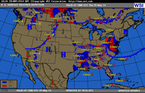
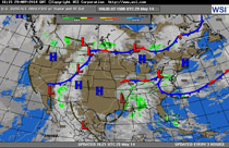
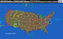
Three views of the weather situation on May 29, 2014. The weather depiction chart (top) shows the Mid-Atlantic states with a concentration of instrument conditions and light rain. The surface analysis chart (center) shows the main ingredient needed for a back door cold front: a strong center of high pressure over New England sending cool—and in this case, moist—air southward. The leading edge of this air mass created the cold front bulging over Virginia and North Carolina. The low over Pennsylvania also helped draw in and lift moisture inland. Low ceilings and visibilities weren’t the only problem that day. Icing airiest (bottom) also were parked atop the vast area affected by instrument weather.
For these reasons and more, we all sit up and take notice if a cold front is affecting our route of flight. You say it looks like your flight will involve crossing a cold front? Better have an instrument rating, be proficient flying on instruments, and be flying an airplane with the performance and weather-detection equipment that will let you make a graceful exit if conditions become dangerous.
But not all cold fronts are turbulent meanies. For example, cold fronts that have exhausted their energy after travelling across the United States are less likely to have widespread thunderstorms. Also, slower-moving cold fronts generally are less hazardous than fast-movers, and so are fronts with relatively small temperature differentials across their boundaries. On the other hand, if you see that surface temperatures ahead of a cold front are in the 90s, and drop to the 50s behind it—well, that’s when you can expect fireworks.
There’s another brand of cold front that sometimes affects the northern tier of states. It’s called a “back door” cold front. Why the name? Well, we typically expect cold fronts to travel from west to east, and be aligned north-south or northeast-southwest. But sometimes, if there’s a large, strong (think high barometric pressure and altimeter settings) high pressure system anchored in Canada or the northern states, this high pressure’s clockwise flow can send cold air southward. The leading edge of this cold air creates a cold front, which most often is depicted on surface analysis, weather depiction, and low-level surface prognosis (“prog”) charts as a front aligned roughly east-west. Because this isn’t the normal, west-to-east path that cold fronts usually take, meteorologists call these back door cold fronts—the back door being the north-to-south path of air.
Back door cold fronts usually are welcome arrivals—especially in the depths of summer, when hot, humid air flows up from the Gulf of Mexico and takes over huge areas of the eastern United States. When a back door cold front pushes this hazy, muggy, convective mess back to the South, the result is clearer skies, lower temperatures, and less humidity. It’s a welcome break from the end-of-summer dog days—one that brings good VFR, light winds, lower density altitudes, better performance, and less sweat during the preflight!
But when it comes to the weather, take nothing for granted. Back door cold fronts can cause trouble. That’s why the events of May 29, 2014, caught my eye. On that day a back door cold front came out of New England and set up over the Mid-Atlantic and Piedmont states. The clockwise flow around the high brought cooler temperatures, yes, but also imported a lot of moisture from the Atlantic. This colder, moist, ground-hugging air pushed its way inland until it dammed up against the high terrain and upslopes of the Virginia piedmont. The end result was anything but clear skies and dry air. It was more like overcast to broken skies at 700 to 1,400 feet, with visibilities of two to seven miles in mist.

Related Articles