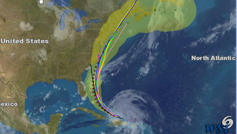
Hurricane Irene is currently entering the Bahamas chain, packing sustained winds of 115 mph. This Category 3 hurricane is capable of “devastating damage,” according to the National Hurricane Center, and pilots with interests in the areas expected to come under Irene’s influence should monitor its progress. These areas that could be impacted include virtually the entire eastern coast of the United States.
To this end, weather provider WSI Corp. will be posting a daily update on Irene at 5 p.m. Eastern. Visit WSI’s website to access the brief update and view WSI-generated hurricane tracking charts. The National Hurricane Center provides official government guidance on this and any other tropical lows or depressions, tropical storms, and hurricanes.


