Mentor Matters: The Narsarsuaq trap
The best laid (flight) plans into Greenland often go astray

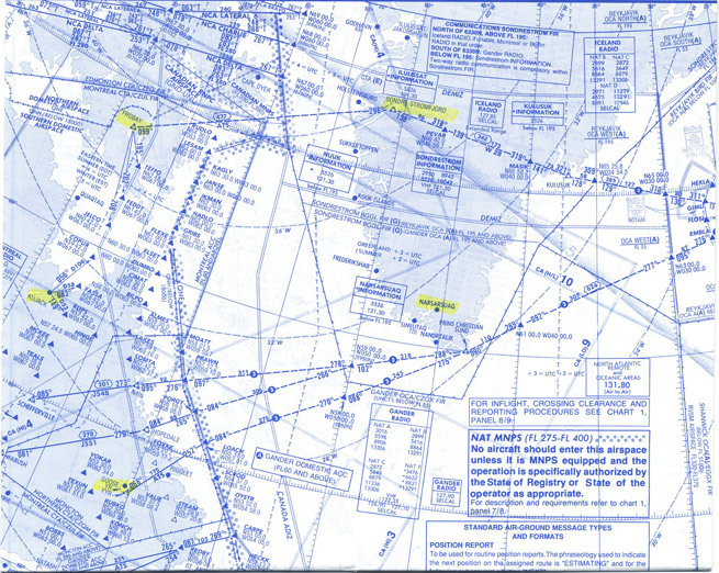
Reproduced with permission of Jeppesen Sanderson, Inc. NOT FOR NAVIGATIONAL USE © Jeppesen sanderson, inc. 2014
For many pilots, a North Atlantic crossing and European trip tops the flying bucket list. Although a properly planned crossing can result in an uneventful flight from northern Canada to Iceland, a trap lays waiting in Greenland for the unaware. At best, the “Narsarsuaq trap” can lead to several hours of stressful fuel calculations and negotiations with ATC. At worst, it can cause a critical fuel shortage that has at least once resulted in an aircraft landing on the Greenland ice cap after exhausting fuel.
At the heart of the issue is required aircraft separation over the North Atlantic. Compared to the five-nautical-mile lateral separation between aircraft flying in the radar-saturated lower 48, the approximately 60 nm (between Flight Level 290 and FL410, inclusive) or 120 nm (outside this range) separation needed over the North Atlantic is downright immense. Fortunately for larger light jets such as the Phenom 300 or CJ3/4, capable of nonstop flight between Canada and Iceland, this required separation is mostly academic. Both climb-to and descent-from cruise altitude will be in the radar environment of either Canada or Iceland, with normal separation requirements.
It’s the aircraft that—because of its range limits—must stop for fuel in Greenland that can be impacted in a big way by separation requirements. Imagine a flight that has departed Goose Bay, Newfoundland, in the morning for the first leg across the North Atlantic to a planned fuel stop in Narsarsuaq, Greenland (BGBW). Narsarsuaq is one of only two airports in Greenland that are generally viable for most light jets, and it lies far closer to the great circle route between Goose Bay and Iceland than does Kangerlussuaq (BGSF), the other decent option.
Although the leg between Goose Bay and Narsarsuaq isn’t terribly long (just under 700 nm), the lack of nearby alternates in Greenland makes fuel planning critical, so the pilot would prefer to fly the leg as high as conditions will allow, typically FL370 or FL390 depending on the performance of the aircraft. Now imagine this aircraft was cleared to cross at FL370, and is approaching Greenland, ready to begin descent. Here’s where the trouble would start.
As there is no radar coverage surrounding Narsarsuaq, ATC will need to maintain 60 miles between our pilot and any other aircraft until the aircraft reaches FL280, where the separation needed jumps to 120 miles. This large area is covered on the chart by circles of 60- and 120-mile radii, and there cannot be a single airplane in these circles at any altitude between the aircraft and FL195, where Narsarsuaq’s airspace starts. The North Atlantic can be very busy, and such a situation is extremely unlikely.
For this reason, ATC will very often simply not allow an aircraft to fly the leg into or out of Narsarsuaq higher than the low to mid 20s. By keeping all the through traffic above our pilot, there’s no need to try and fit him down through an impossibly large (i.e., nonexistent) gap in traffic. This is the trap—a pilot who has carefully calculated fuel based on flight at FL370 is going to burn considerably more when limited to, say, FL230 by ATC. As this bad news typically won’t come until the pilot is about to start engines, it tends not to leave pilots much time to carefully consider the risks and revisit their plan with the same care.
For aircraft that cannot make the flight between Canada and Iceland without stopping for fuel, a stop farther north in Kangerlussuaq can be a safer alternative. It is a bit further to fly if departing Canada from Goose Bay, but given that it has radar service available, a climb to desired altitude is nearly always possible for both legs in and out. This isn’t to say a flight stopping in Narsarsuaq can’t be executed safely, but a prudent pilot should plan the trip in the low to mid-20,000-foot range—and be pleasantly surprised if granted higher.
Neil Singer is a Master CFI with more than 8,500 hours in 15 years of flying.


