P&E Avionics: Synthetic Vision for tablets
Garmin upgrades its app
 Garmin didn’t invent GPS-derived synthetic vision, but adding it to the G1000 avionics suite legitimized and popularized the technology.
Similarly, Garmin wasn’t the first to offer syn-vis on a tablet computer app, but adding it to Garmin Pilot puts the technology in front of thousands of additional pilots, and raises the utility and sophistication of electronic flight bags to a new level.
First, a confession. When I first saw syn-vis on a G1000 in 2008, I regarded it as a gimmick. To me, traditional instrument six packs were perfectly adequate for instrument flight, and colorful graphics of the outside world seemed interesting but unnecessary.
That changed for me on a foggy winter day when I flew a G1000-equipped aircraft on an LDA approach into Hartford-Brainard Airport in Connecticut with rain pelting the windshield. An unfamiliar approach to minimums would normally be a somewhat challenging event, but syn-vis made it simple by constantly providing situational awareness at a glance. I became an instant convert, so I was happy to update my Garmin Pilot electronic flight bag app as soon as syn-vis became available.
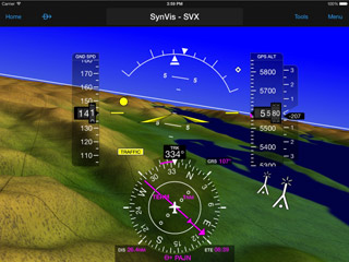
Running it requires a GDL 39 portable receiver and an IFR or VFR Premium subscription to Garmin Pilot. The GDL 39 has an air data attitude and heading reference system (ADAHRS) built into it that senses pitch and roll, and communicates via Bluetooth to a tablet computer (in my case, an iPad; Pilot also works on Android tablets).
I secured the GDL in the back of my RV–4, attached the iPad to the sub-panel where it’s shaded from the bubble canopy, and was immediately impressed by what I saw. The high-resolution display is crisp, clear, and colorful; it looks like a high-fidelity version of a G1000 PFD.
My aircraft is equipped with ADS-B Out (through a Trig transponder), so the GDL 39 receives both ADS-B traffic and weather. (Without ADS-B Out, it would get only partial traffic and full-time weather.)
Once airborne, a few of the syn-vis limitations became apparent. First, in a 10-degree climb, the unit wrongly thinks it’s level. In level flight, it erroneously believes it’s in a 10-degree descent. The reason for this is that the GDL is programmed to believe it is level on the ground—and that works fine in most nosewheel airplanes, but not with tailwheel airplanes like an RV–4. A quick tap of the reset button in level flight quickly recalibrates the unit and it remains accurate the rest of the flight.
The syn-vis display is exceptionally good at showing traffic. Other aircraft appear as tiny white diamonds, then grow into white dots, and finally large yellow spheres as they get closer.
Airports appear as billboards with their four-letter identifiers spelled out. As you fly closer, the runways show up in their proper orientation, and runway numbers appear on the thresholds as they do in real life.
Transparent tapes show GPS-derived altitude, groundspeed, and ground track in the traditional glass-cockpit locations, along with an HSI and magenta trend indicators. Unlike the G1000, however, the syn-vis for tablets doesn’t include a flight path marker (green dot) or highway-in-the-sky boxes to fly through. This version of syn-vis also must be viewed full screen. There’s no split screen to allow a moving map or traffic on one screen and syn-vis on the other.
In sum, Garmin’s syn-vis for tablet computers makes a game-changing technology much more widely available at a tiny fraction of the cost of FAA-certified, panel-mount systems. And while these portable units aren’t nearly as robust as the certified variety, pilots who become accustomed to flying with syn-vis and the situational awareness and comfort it brings won’t want to do without it.
And what looked like a gimmick at first will quickly be regarded as essential to an ever-larger portion of GA pilots.AOPA
Email [email protected]
Touchscreen avionics
Garmin introduces the G3X Touch
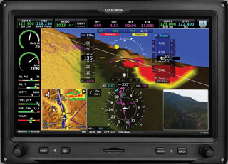 Garmin’s new G3X touchis an all-in-one touchscreen avionics suite for Experimental and light sport aircraft that includes synthetic vision with highway-in-the-sky guidance, a color moving map with terrain warnings, weather and traffic, a digital autopilot, a graphic engine monitor, communications radio, and transponder with ADS-B Out.
The 10.6-inch display uses infrared technology to activate the sunlight-readable screen, as well as four traditional buttons and two knobs for common commands such as direct-to, radio tuning, and setting headings and altitudes.
“Our dedicated experimental engineering team, better known as ‘Team X,’ continues to raise the bar with the introduction of the G3X Touch,” said Carl Wolf, Garmin vice president of aviation sales. “Team X listened to the requests of our customers and as builders themselves—designing products for the activity they love—have delivered a large, intuitive touchscreen flight display, which offers a number of enhanced capabilities that give our amateur-built and light sport customers what they asked for, and more.”
Aircraft owners can install up to three G3X Touch displays in their panel. The touchscreen provides a user interface that uses the same logic and commands as other Garmin products. The G3X Touch also has a split-screen function that allows pilots to divide the display between primary flight display, multifunction display, engine monitor, and IFR and VFR charts.
Weather and satellite radio are available via SiriusXM, and subscription-free weather and traffic can be displayed using a GDL 39 ADS-B receiver. Pilots have the option of controlling Garmin’s Experimental autopilot through a touchscreen interface or a stand-alone control panel.
A new, 10-watt, remote communication radio with “3D audio” can be operated through the G3X Touch. Angle of attack indications can be viewed on the PFD screen or Garmin’s new GI 260, which can be placed in the pilot’s primary field of view.
A single-screen G3X Touch with synthetic vision, video input, a built-in WAAS GPS receiver, air data attitude and heading reference system, magnetometer, outside air temperature probe, interactive mapping, and more has a retail price of $5,499. With an engine information system, the price is $6,099. The GTR 20 remote com transceiver sells for $995, and the GI 260 AOA indicator is $250. AOPA
Email [email protected]


