On the move
Is that sigmet headed my way?
When the weather takes a turn for the worse we pilots do three things, guaranteed: We frantically begin checking and rechecking metars, TAFs, and Nexrad radar; tune in The Weather Channel, and wonder where the adverse conditions are headed—especially if thunderstorms are involved. We want simple answers to very complicated situations. Like, is that line of precipitation echoes going to move across our route of flight?
Frontal movement
Like most everything in meteorology, there are no simple answers. True, our fronts and lows tend to move west to east, following the prevailing westerly winds aloft. However, troughs aloft not only can help create low pressure centers, they can send them on a south-to-north trajectory as the upper wind flow comes around the eastern side of the trough axis.
East of a dry line, a low layer of moist air is topped by dry air aloft. During the day these two layers mix, but when the sun goes down and the dry line moves west, the mixing stops and convection begins. Because dry air prevails, satellite imagery may not indicate dry line activity at first.
Warm fronts move more slowly, typically at 15 knots, with clouds and associated weather extending to as much as 900 nm ahead of the front’s surface position. Stationary fronts? As you might suspect, they move very little—until they’re disrupted by the next weather system. Occlusions? They move slowly, too, at 15 to 20 knots.
Another thing to bear in mind: Lows move toward areas of lowering pressure. You can identify these on the National Weather Service’s Storm Prediction Center (SPC) website’s mesoanalysis page. Select the “Basic Sfc” dropdown menu, then click on “2-hour pressure change.” You might also click on the 3-hour temperature and 3-hour dew point change to further help identify areas that are prime for a frontal intrusion.
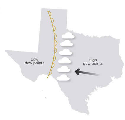
Dry lines—indigenous to Texas, New Mexico, and Oklahoma—are fronts delineated by dew point boundaries. East of the dry line there’s the damp air provided by the Gulf of Mexico. West of it is dry desert air. During the day, dew points rise in the humid air mass as convection begins, reaching a maximum at night. Meanwhile, the dry line moves west, bringing thunderstorms with it. These tend to dissipate by early morning and the dry line then moves back to the east in a cyclical action that some colloquially call “sloshing.”
Thunderstorm cell movement
Ever seen a cold front pushing a line of thunderstorms ahead of it? It’s a common phenomenon. And so is the movement of those storms, as they often travel along a southwest-to-northeast direction, moving parallel to the front’s leading edge and heading toward the front’s parent low. It’s something to think about if you’re planning a flight that might include a frontal crossing. Just don’t try to time your crossing based on a guesstimate of gaps between cells.
The art of predicting supercell thunderstorm behavior is an imperfect one, but forecasters sometimes use a formula to help anticipate a supercell complex’s movement. It’s called 30R75, meaning that the storm motion will be 30 degrees to the right of the mean mid-altitude winds, and at 75 percent of that wind’s speed. But these storm complexes can split, so don’t hang your hat on 30R75. It’s just a nice-to-know bit of knowledge.
So is the fact that thunderstorms tend to continue to propagate behind any outflow boundaries they produce. Many times you can see outflow boundaries, created by cold downdrafts, on Nexrad imagery. They appear as thin, semicircular lines of echoes that radiate out from larger storm cells. They can be powerful enough to generate storm cells of their own.
Larko’s triangle
Talk about a bad neighborhood. Larko’s Triangle—named after the meteorologist who identified it—is a prime location for tornadoes. The triangle is located in the warm sector of a low pressure system, immediately adjacent to a center of surface low pressure, bounded by the cold and warm front, and extending to the first isobar on a surface analysis chart. This is an area with maximum convergence of warm, moist, unstable air. Add any storms already moving across the cold front—as mentioned above—and you can see how all that convection could be packed into a dangerously small zone. Throw in the lifting force of jet stream core winds aloft and you’ve got a setup that no airplane should enter.
Low-level jet streams (LLJs), nearly always a sign of prefrontal bad news, travel northward along a southwest-northeast axis, bringing moisture from the Gulf of Mexico on its way to Larko’s Triangle—and lifting it on the way. LLJs live at low altitudes—generally around 5,000 feet—and move at 50 knots or higher. So the next time you’re flying through the Midwest and experience abnormally strong southerly winds aloft, don’t be surprised if thunderstorms crop up.
These are all large-scale atmospheric motions, and because they are so familiar they are relatively easy to identify and predict. Smaller-scale motions like sea breezes, cold air drainage, and localized terrain-induced winds are quirkier—and thus harder to anticipate. Even so, that doesn’t make them any tamer.
Email [email protected]
Lows and fronts can run into big high pressure systems such as the Bermuda High (which is centered off the East Coast). Bermuda Highs are famous for preventing the eastward progress of any lows and fronts to their west. Sometimes, like troughs aloft, they’ll also send weather systems to the north. Then you have the “ring of fire” situation, where storms fire around the high’s periphery. This situation can last for days during the summer months.
Let’s say the surface analysis chart shows a typical mid-latitude low pressure system on the day you plan to fly. Apart from looking at the low-level surface prognosis (“prog”) charts, how can you get a rough idea of where that low and its fronts will move? One rule of thumb says to look at the alignment of the isobars in the system’s warm sector. The low and its fronts will typically travel downwind, in the direction of the isobars.
What about the speed of a cold front’s movement? This varies according to the nature of the front. Fast-moving cold fronts are the nastiest, and can travel as fast as 40 knots or more. But the weather associated with fast-moving and “normal” cold fronts—which can travel at 20 knots—can affect a region up to 500 nm ahead of the front’s surface position.
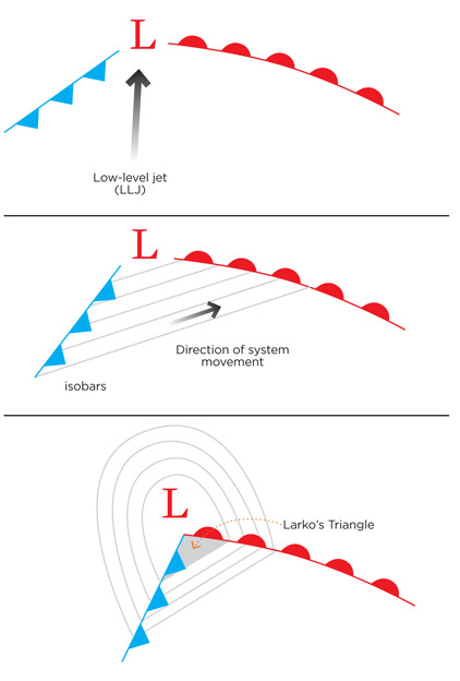
Low-level jet streams often precede cold fronts (top), and the direction of a low-pressure system can sometimes be ballparked by looking at the orientation of the warm-sector isobars (center). Tornadoes frequently appear in “Larko’s Triangle” (above).
Related Articles


