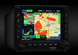
 BendixKing offers pilots a chance to point and touch to control almost every feature of the WAAS-enabled KSN 770/765 GPS navigation and communication display, whether it’s planning a route, changing it in flight, loading an approach, or entering an identifier. Turbulence can defeat even a skilled finger-pointing pilot who might stab at the wrong on-screen choice, so mechanical buttons are available too. Buttons along the sides of the screen constantly change function, and labels, to offer more direct controls when the panel flies out from beneath your finger.
A well-planned online training course helps to understand the unit for those not excited about wading through an owner’s manual. Pacific Coast Avionics in Oregon is offering the unit for $11,495 and installation in a single-engine airplane is $5,200, while a twin-engine airplane installation costs $6,000. Prices for the unit vary by dealer. There is also a 765 model without internal navigation and communications radios priced at $400 less.
No one memorizes an owner’s manual, so the 770 offers constant reminders with labels for the “soft” keys that change function depending on the task, and places reminders in the nearest corner for physical buttons and a joy stick. Charts, traffic, terrain awareness warnings, lightning, and weather are able to be displayed. Temporary flight restrictions are included as one of the displays, decreasing the chance of penetrating the sensitive airspace. Green safe terrain is not displayed on the ground. Data is updated every 28 days via a USB port on the front of the unit.
BendixKing engineers expect that once you set up the menus to your liking, you’ll never need to change the configuration of the screens again.
In flight, you can touch the location you want to go, or drag the course line to a new waypoint if air traffic control should send you to an unplanned waypoint. If airport controllers tell you winds have shifted and you will be using a different instrument approach, all you need to do is bring up the list of approaches, delete the one you were on, and touch the new one. All waypoints for the approach are entered. Guidance is provided throughout approaches and holding patterns. It will figure out the best entry for the holding pattern too.
Rings can be set on traffic displays from two miles to 40 miles, your choice, so you’ll know exactly how far away the traffic is. Weather displays can be zoomed from 10 miles to 2,000 miles.
Airport diagrams can be set up for “pop up” automatic zooming. Once your aircraft is traveling at 30 knots or less, the view zooms in, assuming you are on the ground and need to see airport diagrams. The nearest function includes radio frequencies for airports, air route traffic control, and flight service station frequencies.
It’s obvious that computer displays and finger-tapping cellphones are blending together as avionics technology advances. The fact that functions are configurable by the pilot, with buttonology hints always at the ready, makes this one of the most pilot-friendly units on the market.


