Years ago I sat in the back of a Delta jet following the flight on a portable GPS, and the flight attendant asked a dead-heading pilot onboard to sit beside me to see if I was up to something. Once I demonstrated that I could bring up the airport just below, including its runway length and frequencies, the pilot remarked, “That’s more than they have up front.” Avionics have advanced and so has computer technology, but FlyQ, the electronic flight bag for the iPad, proves that today’s general aviation pilot still has more information than airline pilots.
The just-released FlyQ EFB 2.0 aims most of its new improvements at readability, reliability, and especially the ease of use for the pilot. But its tricks, even if they were included in the earlier version, still amaze. I planned a flight by entering the departure airport (Frederick, Maryland), the destination (Toronto), and the letter “V.” Up popped a navigation log with the best altitudes, based on wind forecasts, already entered for me. Then, for the purpose of this article, I went to the subscription page (there is a 30-day free trial after the app is downloaded from iTunes) to see what it costs. I was surprised to see the new route laid out on a color-coded map of the United States showing states for which I had current chart data in green. I could see by the colorless New York state outline that I needed to download chart data. Subscriptions are $69 for a year of U.S. VFR data, and $119 for a year of both VFR and IFR data.
I had downloaded chart data the night before for Pennsylvania, West Virginia, Virginia, Maryland, New Jersey, and Delaware. The process was started at a restaurant with admittedly slow Wi-Fi. I continued the process at home starting about 7:30 p.m. using what Comcast thinks is blazingly fast Internet connection. By 10 p.m. the download was complete. It’s a slow process.
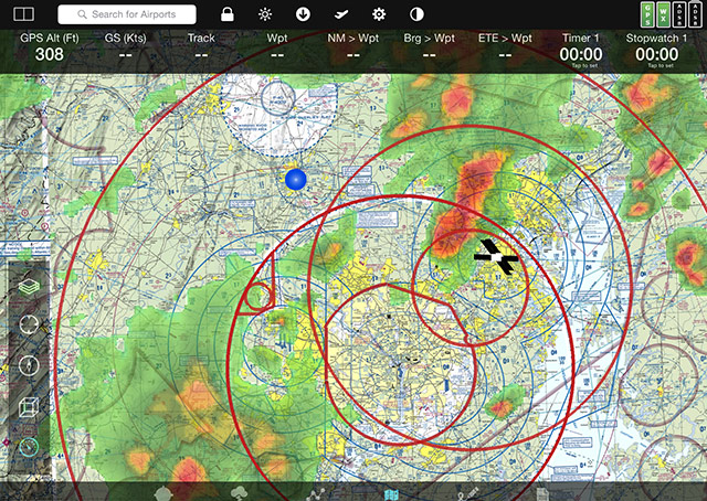
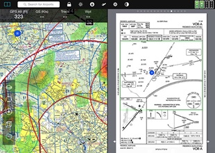
What you have after the download is an enormous bank of terrain, maps, approach procedures, airport data, and more that can display information from ADS-B receivers, but does pretty well on its own. There’s no more waiting; accessing the information is instantaneous. I was impressed that the first time I started the app there was weather radar information already placed accurately on the map waiting for me. I didn't have to dig into a menu to turn it on. Version 2.0 represents major steps to keep pilots from digging through menus. Tap the screen, and a list of information pops up that may include maps, flight plans, weather, airport information, procedures, or a scratch pad that lets you scribble that clearance with your finger so you won’t forget. Then, blessedly, it goes away in six seconds to free up map space or extra real estate for whatever you are viewing. You can view two sources of information at once, such as placing a chart on half the screen with an approach procedure chart on the other half. You can even superimpose the approach chart on the map without any mental gymnastics, but kept separately both display an icon showing the position of your aircraft.
You can customize the display across the top of the screen. The default shows GPS altitude, groundspeed, track, waypoint, nautical miles to the waypoint (I am writing this 25.1 nautical miles from Hagerstown, Maryland, and no, I’m not in the air), bearing to the waypoint, estimated time to the waypoint, a timer, and a stopwatch. In the top right corner are status indicators showing, in my case, strong GPS signals (green box), current weather data (another green box), and two boxes for Automatic Dependent Surveillance-Broadcast and the battery giving your external, separate ADS-B receiver its power. Both are colorless in my case since I do not have ADS-B attached, but I could use any of nearly two dozen receivers available on the market.
The company’s approach is to simplify and speed up a set of vital features instead of adding complication and unnecessary features. There are all sorts of training videos to get you started and an 80-page downloadable booklet that can be printed if you happen to have lots of printer ink and paper. While there is customer support, the company prefers you send an email à la Adobe. When I tried to reach a person I encountered a series of voicemail boxes, but the training videos should get you enough virtual facetime with the company gurus to solve any problems.

Related Articles


