
A Texas deluge rivaling the torrents typically brought by Gulf of Mexico hurricanes flooded several Houston airports when 18 inches of rain fell during a short period of time April 18. Downpours saturated streets and neighborhoods and brought the city to a standstill.
Squall lines stretched from Texas through Louisiana and swamped at least four general aviation airports along Houston’s west side. Flood watches posted through mid-week led to myriad residential evacuations. Hundreds of flights were canceled or delayed at Houston’s Bush and Hobby airports during ground stops, which had a domino effect across the Gulf Coast and elsewhere. At least eight people died and some 1,150 homes were damaged by the storms, Reuters reported.
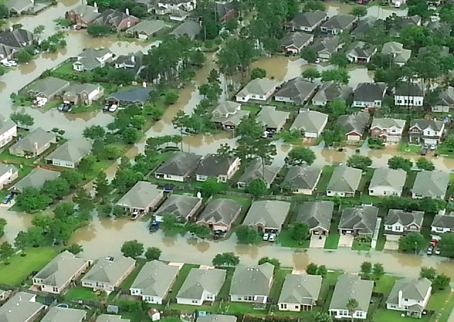
AOPA Texas You Can Fly Ambassador Pat Brown said he was at a friend’s hangar-home when the weather briefly “cleared enough for 1800-foot ceilings and the visibility lifted to VFR conditions” during the afternoon of April 18. Brown jumped into a friend’s Cessna 182 to survey the damage to GA airports along the city’s west side. Brown said extensive water damage was evident as they lifted off from West Houston Airport near the Addicks Dam and Reservoir.
Brown said news reports indicated the Addicks flood control measures “largely did their job but the creeks feeding into it have overflowed their banks. They just weren’t designed to handle that kind of water.”

Brown recorded the scene on a smart phone as flood waters submerged a newly opened S-curve on Texas State Highway 99, also known as Grand Parkway. Houston television station KTRK reported that roads in the area were designed “for a 100-year flood, not the 500-year event we experienced Monday.”
Texas Department of Transportation spokeswoman Raquelle Lewis told the station the department didn’t have the resources or the capability to “allow for a facility to stay dry under such an extreme rain event.” According to the National Weather Service, the state’s average April precipitation is 3.3 inches.
Brown’s flight path along the west side of Houston showed flood damage touching at least five airports: David Wayne Hooks Memorial, Dan Jones International, Weiser Air Park, Sugar Land Regional, and Sport Flyers.
As they flew further west of Houston, “the worst rain seemed to be on the west side of the city in the Cypress Creek watershed, which feeds Bear Creek and Mayde Creek.”
The elevation on the west side of Houston is about 120 feet msl, “so we’re not at sea level but we’re not far above it either,” Brown said.

At Hooks Memorial airport, a major GA reliever, “it was hard for me to tell how much water was in the hangars but it’s certainly all over the taxiways,” he said.
The facility has two parallel runways with a taxiway between them and a separate water runway for seaplane operations. “All of it’s flooded,” said Brown.
Reuters reported that flooding from the April 18 event caused hundreds of schools to close and the news service said emergency personnel performed 1,200 water rescues, including many motorists who were caught by surprise from water swiftly rising around them.
Texas Gov. Greg Abbott declared a state of disaster in nine counties and the American Red Cross sought volunteers to help in ongoing flood-related assistance. The economic impact is not yet known as figures were not yet available April 21 from insurance companies and other businesses affected by the storms.
Southeast Texas might not get much of a break from the rain: The Houston weather forecast called for periods of thunderstorms through April 26, with a brief break in precipitation April 23.

Related Articles


