Weather Watch: A Surface Low's Life
Going from meek to monster, and back again

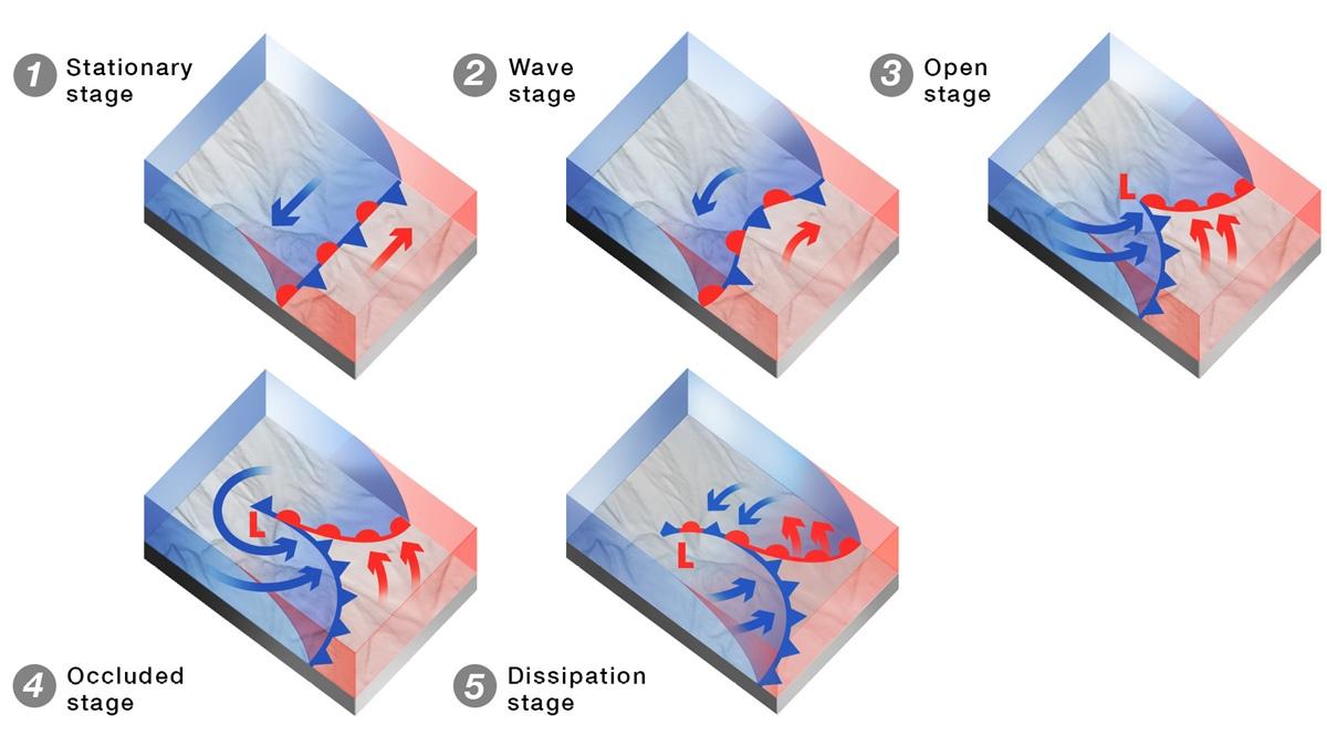
So how does a front come about? It begins innocently enough, with two air masses—one colder than the other—forming a temperature boundary. Not surprisingly, warmer air tends to be to the south, and colder air to the north. In a sense, you could think of this boundary as a stationary front, because there is no motion between the air masses—yet.
That’s where divergent airflows aloft come into play. As an upper-level trough moves over the contrasting air masses, rising air to the east of the trough axis begins to act as a trigger that generates lifting near the surface. Nature abhors a vacuum, goes the saying—and so it is with cyclogenesis (low pressure formation) and frontogenesis (frontal formation), to use meteo-speak. If air is diverging at the top of a column of air, then there must be a convergence of air at the surface to fill the vacuum. Vertical motion begins—and, Houston, we have liftoff.
So how does a front come about? It begins innocently enough, with two air masses—one colder than the other—forming a temperature boundary. In a sense, you could think of this boundary as a stationary front, because there is no motion between the air masses—yet.Now we enter the next step in a frontal system’s life cycle. At the surface, these newly convergent rising actions lower the “weight” of the air column. In other words, air pressure drops, barometers and altimeters register the change, and the air surrounding this small-scale low is drawn toward its center. But air isn’t sucked straight into the surface low’s center. The moment air begins to move toward a low, Coriolis force kicks in and turns it to the right. Now we have a counterclockwise flow around the low. The deeper the central pressure, the stronger the Coriolis force, the faster the winds, and the tighter the spacing between isobars—lines connecting equal surface pressure values.
Once this happens, the low deepens, and its pressure drops even more. Those cold and warm air masses, once stationary, are now on the move—and they begin to move in a counterclockwise direction. Colder air is denser and heavier than warmer air, so it sinks, spreads out, wedges itself beneath the warmer air ahead of it, and causes it to rise. At the same time, the warmer, lighter air rises and begins to ride up and over the colder air mass. What we have now is the classical mid-latitude cyclone model (“cyclone” as in a garden-variety low pressure system, not the hurricanes identified in the eastern Pacific Ocean as cyclones) first identified by Norwegian meteorologists during World War I.
The deeper the central pressure, the stronger the Coriolis force, the faster the winds, and the tighter the spacing between isobars.The trouble begins as the maturing low and its fronts begin lifting air at such a rate that dense cloud masses rise, cool, and saturate to the point that thunderstorms pop up. How intense they become depends on a complicated set of variables. Heat and moisture from the Gulf of Mexico, feeding the warm sector of a frontal complex, provide a lot of energy for monster, tornadic supercell thunderstorm complexes. Triple-digit jet stream core winds help boost the clash between air masses. Low-pressure troughs east of the Rockies kick off plenty of intense Midwestern frontal complexes. So do strong temperature contrasts across the frontal boundaries. And as you might suspect, lifting forces are apt to be greatest at and near the parent low pressure center—particularly in Larkos’ triangle, the zone bounded by the low pressure center and the first two isobars to its south, connecting the cold and warm fronts.
In the system’s mature stage, the faster-moving cold front often catches up with the warm front ahead of it. The upper-level low pressure center moves north of the surface low’s position, moving the surface low away from its original location. Without a strong surface low to sustain it, the convective fuel from the warm sector is cut off. It’s the beginning of the end for our cyclone model. An occluded front stretches to the north of the rapidly aging cold and warm fronts, terminating in a new, weaker low that deprives the original system of divergence.
Ultimately, the whole system falls apart, boundaries and all, as the cold air around the occlusion further dampens any vertical motion. This whole process, from beginning to end, typically takes just a few days, and occurs a dozen or so times per month across the continental United States. That’s why the concept of the cyclone model’s life cycle is so important to understand as we get into the heart of the flying season. If you don’t learn anything else, meteorology professor Lee Grenci of Penn State used to say, then make sure you have a handle on the cyclone model.AOPA
Email [email protected]


