Understanding ADS-B In
Datalink pitfalls you want to avoid

FIS-B to offer new products
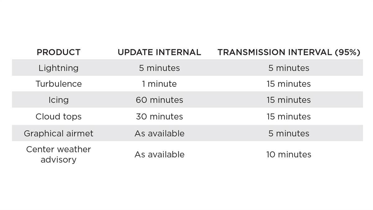 By this June, FIS-B broadcasts are scheduled to gain lightning strikes, turbulence, icing, cloud tops, graphical airmets, and Center Weather Advisory feeds. But the software in your electronic flight bag and your avionics will need to be updated before you can access the new products.
“It is up to each vendor to determine if they will update their software to incorporate the new data and new products,” said Rune Duke, AOPA’s senior director of airspace and air traffic. He expects that some companies will be ready to display the new information very soon after it becomes available. “Existing products should not be affected.”
The FAA Surveillance and Broadcast Services Program’s Essential Services Specification establishes the required update and transmission intervals for the new products.
The update interval is the frequency at which the product data is available from the source. The transmission interval is the amount of time within which a new or updated product transmission must be completed, and the interval at which the product is rebroadcast. Corresponding intervals for current FIS-B products can be found in the Aeronautical Information Manual, Table 7-1-1.
Because these intervals vary by product, it can be important to know which Nexrad radar image you’re viewing. The update interval for a regional Nexrad composite reflectivity image is five minutes, and the FIS-B transmission interval is 2.5 minutes—but the continental United States (CONUS) image is updated only every 15 minutes, with a 15-minute transmission interval. A CONUS image will always be older than a regional Nexrad image. —MC
See AOPA’s online ADS-B resources and ADS-B selection tool.
ADS-B uses GPS satellites instead of ground-based radar to determine aircraft location and is a key technology behind the FAA’s Next Generation Air Transportation System. The FAA will require ADS-B Out capability for flights after January 1, 2020, in airspace where a transponder is required today. ADS-B In—which provides the ability to display FIS-B weather, notams, and other data on cockpit displays or wirelessly on a tablet—is optional.
FIS-B uses the 978 MHz datalink frequency to broadcast Nexrad radar images, METARs, TAFs, airmets, sigmets, convective sigmets, pireps, winds and temperatures aloft, distant and Flight Data Center notams, and information on temporary flight restrictions. A wide variety of portable receivers, including some you can build yourself, will display the data through apps running on a tablet computer or smartphone.
Notam limitations
On your way to Canyonlands Field Airport in Moab, Utah? If you received a complete briefing, you would have seen this: !CNY 12/012 CNY AD AP CLSD EXC HEL 1801021400-1805010600. However, that aerodrome notam doesn’t appear in the FIS-B data stream. The airport’s website tells the story: “The runway at CNY is currently closed (through April 30, 2018).” While Runway 3/21 and Taxiway A are closed for construction, the airport remains open to helicopters, which can land on the ramp.
On September 26, 2016, the FAA announced via notam that it would no longer broadcast Notam-Ds and Notam-FDCs with an effective date or issuance date 30 days in the past—and that notam was cancelled not long after it was issued, said Rune Duke, AOPA’s senior director of airspace and air traffic.
The change was made to free up bandwidth for new FIS-B products, and the FAA estimates that about 20 percent fewer notams are being uplinked. “FIS-B has only 323 bytes per channel per second—that’s not kilobytes or megabytes, but only bytes,” Duke explained. “Our philosophy is FIS-B is for tactical decision making and the new weather products are of value. However, the FAA did a poor job communicating the limitations placed on the notam broadcast.”
The change appears in Change 1 to Advisory Circular 00-63A, but the majority of pilots are not reading the appendix where it’s contained, added Duke, who has asked the FAA to add the FIS-B notam limitation to the Aeronautical Information Manual. He said the agency has agreed to the request, and in the meantime will issue an Information for Operators on the subject.
“FIS-B is for tactical, in-flight decision making and situational awareness. It does not replace a preflight briefing,” Duke said, adding that runway and aerodrome closures are among those likely to be affected, because some are for construction projects that take longer than 30 days.
System knowledge
There has been some misconception that an aircraft must receive three ADS-B ground stations in order to receive FIS-B information—only one is required. Perhaps this is being confused with the look-ahead range, a distance in nautical miles based on the type, or tier, of ADS-B ground station received: low altitude (up to 3,000 feet agl); medium altitude (up to 14,000 feet agl); and high-altitude (up to 24,000 feet agl). AIM Table 7-1-2 provides the details. In addition, there are surface radios at some larger airports.
Depending on altitude, avionics may receive FIS-B data from more than one ground station. Each ground station delivers the full range of FIS-B products relative to its tier, and the aircraft’s avionics should prioritize which ground station to process based on its proximity and tier. Two-thirds of ADS-B ground stations are in the low-altitude tier, but medium- and high-altitude radios can be received over a longer distance.
Check the manuals for the products on which you display your weather data, and learn how to tell when certain information is unavailable. Many will offer a display that confirms key products are being received—you might have to push a button or two—or visually alert you to missing graphics, such as Nexrad images.
It’s important to understand how your equipment operates, and to know the system’s limitations. And heed the AIM’s advice that “FIS should not serve as the sole source of aviation weather and other operational information”; use it to supplement a thorough briefing from your provider of choice. AOPA
Email [email protected]