ASI News: A long and winding road
Heeding the lessons of flying in the mountains
 During mountain flying, the airplane is closer to its performance limits, the pilot is closer to the limits of his or her skill, more things can go wrong, and there are fewer options in an emergency. Factors that increase risk even in flatland flying, such as density altitude, night, weather, and wind, can turn a normal mountain flight into a hazardous trip.
To help mitigate the increased risk, every mountain flight demands extensive flight planning, including careful route selection. Students are often taught to seek the most direct route, and your instructor will likely sign you off to fly relatively straightforward trips for solo cross-countries. But sometimes direct is not best, and it’s important in developing your overall skill as an aviator to learn about the exceptions.
 In many cases, direct flights aren’t feasible in mountainous areas: Terrain can easily “out-climb” many light general aviation aircraft, and flying direct also limits your options in the event of an emergency.
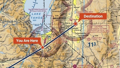
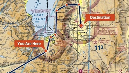
Consider a flight near Lake Tahoe near the California/Nevada state line—which route would you choose? Depending on your aircraft, you could potentially climb over the mountains and fly direct. But is that the best choice? Now look at the long, circuitous route that hugs the shore of the lake before turning east through Spooner Summit Pass and then south to your destination. While longer (and requiring more navigation work), it offers lower terrain, nearby roads for emergency landings, and a large body of water for ditching. In the event of an engine failure, would you rather put the airplane down in a lake or take your chances with jagged, snow-capped peaks?
The technology we have today is incredible—our smartphones can operate as powerful navigation tools even from a mile high, and for many, paper charts and plastic plotters are a thing of the past. Why spend time planning a flight on the ground when we’ll have all the tech we need to go directly to our destination, in the palm of our hands, aloft? That convenience of knowing precisely your point in space is useful and greatly enhances our situational awareness. But when we take into consideration our options in an emergency, flying direct rarely gives us the most options, even when not contending with peaks of the Sierra Nevada.
Whenever you plan a flight, choose a route that builds in outs in case of emergency or other unforeseen circumstances. Deviate a couple of miles from the direct route and use airports as waypoints—diversions or fuel stops are now part of the plan. Take terrain into consideration, too. Change your route to fly closer to a highway, or other possible emergency landing spots, instead of directly over a swamp, forest, marsh, or densely populated area. If you fly over open water, modify your route to minimize time away from land. These changes may make the trip longer, but you’re giving yourself options. The extra time on the Hobbs will be worth it to increase the likelihood of a positive outcome after an inflight emergency.

Weather wherever you go
Pilots flying in mountainous regions need to consider how they’ll obtain updated weather information during flight and on the ground. While ADS-B weather is free and can be accessed in almost every corner of the United States, its technology limits coverage in mountainous terrain where line-of-sight between your aircraft and ground-based towers cannot be assured. Satellite weather simply requires open sky to ensure uninterrupted weather data. While access to satellite weather does require a subscription and a receiving device, it may be money well spent in the backcountry.
 There I was: Mark Murphy
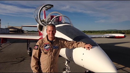
Over the past 33 years of flying—which includes aerobatics in the P-51 Mustang, T-6 Texan, Japanese Zero, and F4U Corsair—pilot Mark Murphy has accumulated his share of stories. In this episode, he joins us to talk about the time he experienced an unexpected flat spin in a Christen Eagle and how he got out of it.


